
 There
is a short hike along a popular trail from Lodgepole campground.
The trail is a gentle uphill all the way to the falls with a few
steeper sections. You will follow the Marble Fork of the Tokopah
River.
There
is a short hike along a popular trail from Lodgepole campground.
The trail is a gentle uphill all the way to the falls with a few
steeper sections. You will follow the Marble Fork of the Tokopah
River.
Much of the rock around the Lodgepole area is the Granite of
Lodgepole. At over 115 million year old, it is older than all the
other rocks surrounding it. The granite is exposed in the Marble
Fork of the Kewah River, in various outcrops on the valley floor,
but is best exposed near the falls (and the coordinates).
Glaciers filled the valley during the Tioga (14-25 thousand
years ago) and Younger Tahoe (42-50 thousand years ago)
glaciations, and at least one pre-Tahoe glaciation. From the
coordinates by the falls, you can see how at least three glacial
episodes altered the valley profile.
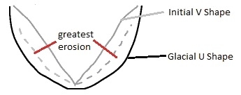 Glaciers tend to follow the preexisting drainage.
They take the V-shaped valleys that flowing waters carve and widen
out the bottom of the valley into a U. The glacial ice puts the
most erosion on the lower portion of the valley sides, so it widens
out the V shape into a U
Glaciers tend to follow the preexisting drainage.
They take the V-shaped valleys that flowing waters carve and widen
out the bottom of the valley into a U. The glacial ice puts the
most erosion on the lower portion of the valley sides, so it widens
out the V shape into a U
While steep walled, almost vertical walled valleys such as
Yosemite are often portrayed as typical of glacial valleys, they
are actually at one extreme of the range of glacial valley
profiles. That sheer-walled profile can be seen from the waterfall
to a short distance downstream. After that, the valley profile
smoothes out into a more open U shape. The smoother more open
profile is actually more typical of glacial valleys.
For those glacial valleys that develop sheer walls while filled
with glacial ice, some of them do not retain that shape after the
ice recedes. The ice helps support the steep cliffs that the
glacier carvs, but once that supporting ice melts, the rocks that
make up the cliff faces collapse forming talus slopes at the base
of the cliffs (see
Tokopah Talus Slope EarthCache)
Logging requirements:
Send me a note with :
- The text "GC2XJWT Tokopah Glacial Valley Geomorphology" on the
first line
- The number of people in your group (put in the log as
well).
- Describe the angle of the glacial valley walls near the falls
and about 0.5 mile down stream.
- When facing downstream, which side of the sheer-walled portion
of the glacial valley did not have enough structural integrity to
remain steep?