Vocabulary
A polyomino is a shape made by connecting any number of
squares together by their edges. A domino is a polyomino. So is
every black area of every crossword puzzle. Polyominoes are an
important part of various kinds of logic puzzles including, as you
may have guessed, the one on this page. Perhaps I should have named
this cache “Poly Want a Cracker” or “The Poly and
the Ivy” or something. (If you have a stupid/amusing
alternative cache title, you could include it in your log. It would
make my day. Yes, really.)

An Example Puzzle
Please consider the “map” below. It contains four
items: two CACHEs and two TREEs. When the proper borders are drawn
in, each item is represented on the map by a polyomino containing
all of the item's letters, in no particular order or configuration.
Each letter on the map is used in exactly one item – in other
words, items cannot overlap and all the letters on the map must be
used. Can you divide the map into the four polyominoes?
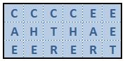
Well, sure you can. Here's what you came up with - the only
possible solution. Good job!

The Real Deal
Bigger is better, right? Please find below a 10x10 map which
contains a SHELTER, a LIGHTPOLE, and a number of CACHEs and TREEs.
Your mission is to divide the map into the appropriate polyominoes,
following the same rules as the example.
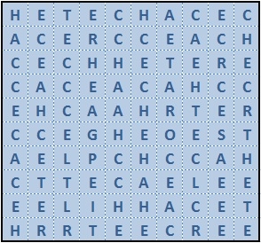
Once you’ve done that, you can find this cache at
N 39° 56.ABC
W 086° 0D.EFG where:
- A = the
number of TREEs touching the SHELTER
- B = the
number of CACHEs shaped like a plus sign
- C = the
number of CACHEs touching the edge of the map
- D = the
number of CACHEs touching the LIGHTPOLE
- E = the
number of TREEs shaped like a square
- F = the
number of CARs on the map if you treat it like a word-search
grid
- G = the
number of CACHEs that won't fit into a 3x3 area
Here's a
geochecker link to verify your solution.
The cache is a few steps off an established dirt path, well into
the park. Please DO NOT trespass on the nearby residential property
or seek this cache when the park is closed. Please DO consider long
pants, bug spray and appropriate footwear. Mark your car with your
GPS, enable your bread crumbs and/or carefully note your turns on
the paths. Have fun!