VERSION FRANCAISE
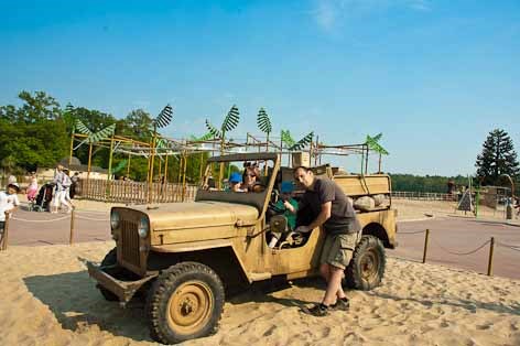
Bien sur la mer de sable est connue pour son parc d’attractions. Mais le centre d’intérêt pour cette earthcache est son étendue de sable. Attention le parc d’attraction n’est pas ouvert toute l’année et son accès est payant. Pour connaître les dates d’ouverture et les tarifs, aller sur le site de la mer de sable.
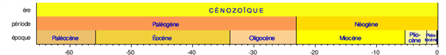
Pour connaitre l'origine de la mer de sable, il faut donc remonter un tout petit peu dans le temps, à l’ère cénozoique, qui se trouve sur cette échelle de temps géologique dont l’unité est le million d’années :

Vous l’avez trouvée ? non ! c’est le « C » sur fond jaune. Voici donc un zoom sur cette période qui débute il y a 65 millions d’années :
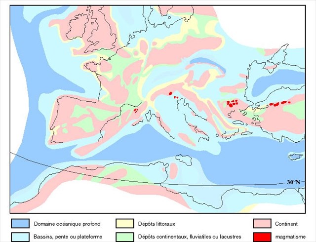
Avant cette période, la mer recouvrait beaucoup plus l’Europe que de nos jours, comme le montre la carte ci-dessous :
A l’ere cénozoïque, la mer stampienne se retire laissant des trace d’ilots, de lagunes, des bancs de sable, des calcaires coquilliers qui vont présager des futurs reliefs après les glaciations du quaternaire.
C’est donc en se retirant que le sable apparaît dans plusieurs régions et en particulier sur des buttes témoins dont les altitudes oscillent autour de 100m. Il semblerait d’ailleurs qu’il est presque impossible de trouver des sables plus anciens, car ils sont transformés en grès.
Par exemple, la plus grande partie du sable du sahara est en fait recent, c'est le sable côtier, transporté à l'intérieur par le vent, ou fabriqué sur place (hoggar par ex.) par le vent et le soleil. Il reste toutefois quelques sables secondaires (au sud de l'algérie de l'égypte et de la lybie, au nord du mali, par ex) qui n'ont pas encore été recouverts par le "sable voyageur" recent.
Quelques années plus tard (toujours à l’échelle géologique), la forêt a pris ces droits sur se sable d’où la création de la forêt d’Ermenonville telle qu’on la connaît aujourd’hui. D’autres forêts sont apparu avec se même sable dont la forêt de Fontainebleau.
Enfin, les moines de l’abbaye de Chaalis proche, et certainement les villageois avoisinants exploitèrent une partie de la forêt pour leurs besoins, ce qui en fit cette étendue de sable au milieu de la forêt d’Ermenonville : La mer de sable.
Pour valider la cache il vous faudra :
- Aller en N 49° 08.765 E 002° 40.627 et trouver ou demander la date de création de la mer de sable,
- Estimer la surface de cette etendue de sable. Attention car une vue aérienne (google earth par exemple) est trompeuse. Pour cela, prener le train et mesurer la distance entre le point de départ et le point d'arrivée au camp des trappeurs. Sachant que la mer de sable est approximativement un triangle équilatéral et que la distance mesurée est l'un de ses côtés, vous pouvez estimer la surface.
- Prendre l'altitude du point le plus bas et du point le plus haut pour confirmer les propos du texte sur la période de création de la mer de sable. Pour information le point le plus bas se situe à l'entrée du parc et le point le plus haut est vers "la piste de l'ouest"
Envoyer par mail personnel les solutions pour valider la cache.
ENGLISH VERSION
La mer de sable (sea of sand) is known for her theme park. But the focus for this earthcache is her area of sand. Be careful, La mer de sable isn’t open year-round and there is a fee for entrance. For information on opening dates and rates, go to the sea of sand website.
To know the origin of the sea of sand, it must go back a little in time, the Cenozoic era, which is on the geologic time scale whose unit is a million years:
Have you found it? no! It is the "C" on the yellow background. Here is a zoom on this period that begins there are 65 million years:
Before this period, the sea covered much more of Europe than today, as shown in the map below:
In the Cenozoic era, the Stampian sea withdrew leaving traces of islands, lagoons, sand banks, shelly limestone that will predict future relief after the Quaternary glaciations.
It is by removing that sand appears in several regions, particularly on outliers whose altitudes fluctuate around 100m. It seems indeed that it is almost impossible to find older sands, as they are transformed into sandstone. For example, most of the sand of the Sahara was in fact recently, the coastal sand, carried inside by the wind, or manufactured on site (eg Hoggar.) by wind and sun. There are still some sand school (south of Algeria to Egypt and Libya to the north of Mali, for example) that have not yet been covered by the "sand traveler" recent.
A few years later (still in the geological scale), the forest has taken these rights to the sand where the creation of the forest Ermenonville as we know it today. Other forests are introduced with the same sand like forest of Fontainebleau for example.
Finally, the monks of the Abbey Chaalis, and certainly the villagers nearby, exploited a part of the forest for their needs, which made this stretch of sand in the middle of the forest Ermenonville: The sea of sand.
To validate the cache, you'll need to :
- Go to N 49° 08.765 E 002° 40.627 and found or ask when the sea of sand was created,
- estimate the surface of the sand. Be careful that an aerial view (google earth for example) cannot give the correct answer. For that, take the train and measured the distance between the starting point and ending point to the camp of trappers. Knowing that sea of sand is approximately an equilateral triangle and the distance measured is one of the side, you can estimate the surface,
- Take the elevation of the lowest and the highest point to confirm the text on the period of creation of the Sea of sand. For information, the lowest point is near the park entrance and the highest point is near the "piste de l'ouest"
Send me solutions to personal email to validate the cache.