Merci de remettre la cache bien en place / Thank to put the cache carefully
FRANCAIS
Amboise, "Ambacia" en latin, signifie "entre deux eaux". Le nom de la ville fait référence à son passé et à sa situation géographique priviliégiée : le plateau des châteliers qui surplombe les vallées de la Loire et de l'Amasse. La cité se développe profitant de la protection naturelle des eaux et de l'installation d'une place forte.
Votre parcours (1h30 - 2h00) vous fera découvrir le vieil Amboise, vous devrez collecter des indices aux Waypoints et vous pourrez trouvez 6 autres caches. Nous vous conseillons de vous procurer à l'office du tourisme, le dépliant "Flanerie à Amboise" "Amboise, l'eau, les hommes, la ville" qui vous offrira un support pédagogique pour cette promenade.
Garer votre véhicule en bord de Loire sur le grand parking
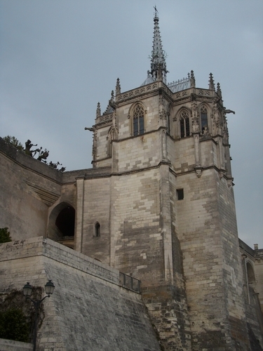
Wp1 : N:47°24.773' E:000°59.018' L'église Saint Florentin
Quelle est la hauteur au dessus du niveau de la mer ? X.Y= ?
Wp2 : N:47°24.767' E:0°59.195 Les façades à pan de bois
Quel est le numéro de cette maison ? Z = ?
En continuant votre parcours jusqu'au WP suivant, vous pouvez chercher la cache L'Amasse.
Wp3 : N:47°24.745' E:0°59.362 Les habitations troglodytiques
Quelle est la date gravée dans la pierre au niveau du puits ? D = ?
Wp4 : N:47°24.614' E:0°59.539 Le château du Clos Lucé
Quelle est la hauteur au dessus du niveau de la mer ? U.V= ?
En continuant votre parcours jusqu'au WP suivant, vous pouvez chercher la cache Le Clos Lucé.
Wp5 : N:47°24.766' E:0°59.341 La table d'orientation
Quel est le chiffre gravé en bas à gauche sur le pilier ? C = ?
En continuant votre parcours jusqu'au WP suivant, vous pouvez chercher la cache La Butte de César.
Wp6 : N:47°24.753' E:0°59.915 Le rempart Gaulois
Sur le panneau il est marqué "Talus primitif marqué par NC" N est le nombre
Avant de repartir, vous pouvez chercher la cache Le rempart Gaulois.
Faites demi-tour et continuer votre parcours jusqu'au WP suivant, vous pourrez découvrir les Vestiges Gallo-Romains. Wp7 : N:47°24.914' E:0°59.396 La Maison des Pages
Le nom de la serrure finit par un D, combien de R dans ce nom ? B = ?
Vous pouvez désormais calculer les coordonnées de la cache. Avant d'aller à la cache finale, vous pouvez chercher la cache Le tunnel de l'Amasse.
Puis vous pouvez faire la cache Le châtellier qui suit le parcours pour arriver à la cache.
LA CACHE.
N: (X-Y-C)° (Y+N) .((D+7)/2 - 3x(U+1))
E: V° (Z+C+1). (X+Z+2xB)
Vous avez trouvé, Bravo, à bientôt . N'hésitez pas à checker
ENGLISH
Amboise, "Ambacia" in Latin means "Between two waters". The name of the city refers to its past and its privileged geographical situation : the châteliers plateau which overlooks the Loire and the Amasse valleys. The city spreads out, taking advantage of the natural protection of the rivers and the development of a fortress.
During your walk (1h30 - 2h00) you will discover the old Amboise, you should collect clues at Waypoints and you could find 6 others caches. We advise to you to take at Tourist Office, Brochure "Strolling around Amboise" "Amboise, the river, the people, the town" where you could find all explanations and historicals informations about Waypoints.
Park your car at Main parking near Loire river.
Wp1 : N:47°24.773' E:000°59.018' Saint Florentin's church
What is the height above sea level (it's written in french) ? X.Y= ?
Wp2 : N:47°24.767' E:0°59.195 Old timbered-houses
What is the number of this house ? Z = ?
Keep going on at the next WP, you can find the cache L'Amasse.
Wp3 : N:47°24.745' E:0°59.362 The cave-dwellings
What is the date engraved in the stone at the well ? D = ?
Wp4 : N:47°24.614' E:0°59.539 The casle of the Clos Lucé
What is the height above sea level (it's written in french) ? U.V= ?
Keep going on at the next WP, you can find the cache Le Clos Lucé.
Wp5 : N:47°24.766' E:0°59.341 View-Point indicator
What is the number engraved on the lower left ? C = ?
Keep going on at the next WP, you can find the cache La Butte de César.
Wp6 : N:47°24.753' E:0°59.915 Le rempart Gaulois
On the sign it's written "Talus primitif marqué par NC" N is the number
Before leaving, you can find the cache Le rempart Gaulois. Go back and keep going on at the next WP, you can watch Gallo-Roman vestiges. Wp7 : N:47°24.914' E:0°59.396 La Maison des Pages
The brand of the lock end by a D, how many R in this brand ? B = ?
You can go to find the Final. Before going to the final, you can find the cache Le tunnel de l'Amasse.
Then the cache Le châtellier which is the way to go to the final.
THE CACHE.
N: (X-Y-C)° (Y+N) .((D+7)/2 - 3x(U+1))
E: V° (Z+C+1). (X+Z+2xB)
Good job, you found it, see you soon. You can use the checker
