Urseetal
Jump to English Version
Dieser Cache führt euch auf eine schöne Wanderung durchs Urseetal.
Der Cache ist sowohl als Rundweg (ca. 9 km), als auch als One-Way mit gleichem Rückweg (ca. 6 km) zu bewältigen.
Geh-Faule können in der Nähe von Stage 1 parken, die Informationen sammeln, mit dem Auto in Richtung Final fahren und von dort aus zum Final (ca. 3,5 km) laufen.
Die Wanderung führt durch ein Naturschutzgebiet. Bleibt auf den Wegen und verhaltet euch angepasst.
Das Final ist nicht mit dem Auto erreichbar.
Wir empfehlen euch die lange Runde zu gehen und euch im schönen Urseetal zu erholen!
|
Das Urseetal:
Das Urseetal ist ein Seitental der Haslach im Landkreis Breisgau-Hochschwarzwald. Verschiedene kleinere Bäche speisen den Ursee im Naturschutzgebiet Ursee. Aus dem Ursee fließt der Urseebach durch das Naturschutzgebiet nach Lenzkirch, wo er in die Haslach mündet. Diese fließt noch innerhalb von Lenzkirch in die Gutach, die nach der Haslacheinmündung Wutach heißt und der Wutachschlucht ihren Namen gegeben hat. Auf Grund seiner seltenen Flora und Fauna wurde der Bereich um den Ursee schon im Jahre 1940 zu einem der ersten Naturschutzgebiete im Schwarzwald erklärt.
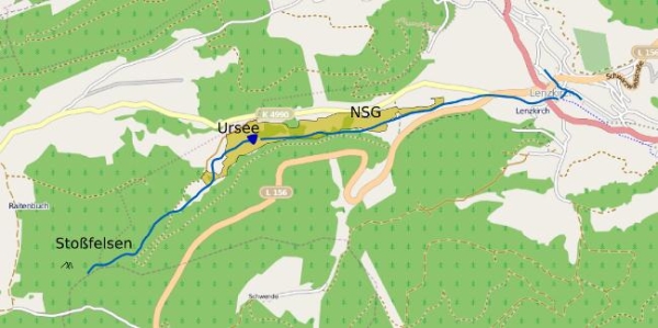
Das Urseetal erstreckt sich im Westen von Lenzkirch Richtung Raitenbuch. Den Südhang des Tales durchschneidet die Straße von Lenzkirch nach Fischbach und Schluchsee. Im Tal selbst verläuft die Straße nach Raitenbuch. Erst auf Höhe des Ursees steigt diese Straße bergauf, bis sie schließlich auf der Raitenbucher Höhe wieder zum Windgefällweiher hin abfällt.
|
Entstehung:
Vom großen Eisfeld, das die höchsten Lagen des Schwarzwaldes um den Feldberg bedeckte, schoben sich einzelne Eisströme in angrenzende Täler. Die Gletscherzungen aus Haslach- und Urseetal erreichten östlich von Lenzkirch bei Kappel und Holzschlag ihre größte Ausdehnung. Vor allem aus Lage und Zusammensetzung der Moränen (Gletscherschutt) ist zu schließen, dass der Urseegletscher über die Höhe von Raitenbuch nach Osten vorstieß.
Wichtiger Beleg dafür ist der südöstlich des Möslehofes auf der Höhe 846,8 m ü.d.M. das Tal querende Wall, der als rechte Seitenmoräne des Gletschers zu erklären ist. Diese fällt als schmaler Waldstreifen in dem Waldwiesental auf. Zwei Rückzugsphasen des Eises werden durch Moränen markiert.
Etwa 750 m unterhalb des Sees liegt die das Tal abriegelnde Pulverhausmoräne. Durch den sandig-kiesigen und deshalb trockenen Boden wächst hier ein Kiefern-Fichtenwald mit Heidelbeersträuchern an den Rändern. Der Waldbestand unterscheidet sich deutlich von dem der Umgebung.
Mit fortschreitendem Abschmelzen des Gletschers verlor dieser seine Verbindung zur Hauptmasse des Eises. Dies bewirkte der etwa 70 m über dem Niveau des Windgfällweihers liegende Sattel bei Raitenbuch. Damit konnten die Schmelzwasserbäche auch keinen Moränenschutt von oberhalb liegenden Gletscherenden mehr ins Urseetal mitbringen. Im Gegensatz zum benachbarten Haslachtal wurde das Urseebecken deshalb gegen Ende der Eiszeit nicht gänzlich aufgefüllt.
Ein weiterer Moränenwall befand sich 500 m weiter talaufwärts; er wurde aber inzwischen fast gänzlich zur Kiesgewinnung abgebaut. Die Moränenwälle stauten das abfließende Schmelzwasser, so dass ein etwa 1200 m langer, bis 250 m breiter See entstand. Mit zunehmender Eintiefung der Abflussrinne des Urseebachs sank der Seespiegel um etwa 5 bis 6 m. Dadurch und dank der folgenden Verlandung durch Moore reduzierte sich die ehemalige Seefläche bis heute auf rund 1/80 ihrer ursprünglichen Ausdehnung. Der heutige Ursee ist acht bis zehn Meter tief und die Verlandung nimmt immer mehr zu. Historische Fotos belegen, dass der Ursee allein seit den 1930er Jahren beträchtlich geschrumpft ist.
|
Der Ursee:
Das Wasser des Ursees enthält Huminsäuren aus dem angrenzenden Moor und erreicht eine Tiefe von bis zu etwa 10 m. Von den vorkommenden Wasserpflanzen sind der Gemeine Wasserschlauch und die Kleine Teichrose zu erwähnen. Am Ufer überdeckt eine schwimmende, von dicht verfilzten Pflanzen aufgebaute, beim Begehen nachgebende "Schwingdecke" das Gewässer. Darunter kann die Wassertiefe noch bis zu 3 m betragen (Nicht betreten, Gefahr!).
Noch vor 80 Jahren war das Ufer frei von Baumwuchs und daher der See gut einsehbar. Aktuell ist der See nur von der Höhe des Urseerundweges von Süden her einzusehen, am besten nach der Schneeschmelze und vor der Vegetationszeit. Von den übrigen Seiten hindern Fichten und Birken den Blick auf den See.
|
Die Badenweiler-Lenzkirch-Zone (BLZ):
Eingeklemmt zwischen Graniten, Gneisen und Anatexiten zieht ein schmaler Streifen aus Konglomeraten, Grauwacke, Schiefern, Tuffen, Glimmerporphyriten, Porphyragglomeraten (Trümmerparphyren) und quarzarmen Porphyren durch den südlichen Schwarzwald von Badenweiler über Sirnitz, Belchen, Schönau, Präg, Bernau, Aha und Lenzkirch bis zum linken Talhang der Gutach bei Kappel-Gutachebrücke.
Auf Lenzkircher Gemarkung trifft man weiterhin Zeichen für eine Mikroplatten-Tektonik, bei der sich eine Erdscholle unter die andere geschoben hat. Die Erforschung dieser Mikroplattentektonik findet entlang der Badenweiler-Lenzkirch-Zone statt.
Trümmerporphyre sind ein charakteristisches Merkmal des Urseetals. Sie sind ein Zeichen früherer vulkanischer Aktivität in diesem Gebiet. Man findet sie neben dem Weg vom Silberbrünnle nach Lenzkirch, außerdem im Steinwall des Haus Ursee. Auf der gerade beschriebenen Strecke finden sich innerhalb weniger 100 m wenigstens 10 verschiedene Felsarten.
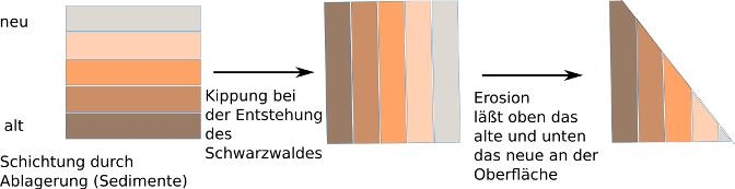
Das Schwarzwald-Grundgebirge liegt hier nach der Kippung der Erdschollen nach Osten an der Oberfläche. Daraus stammen die Granite und Gneise, die man in großer Zahl findet. Der Schwarzwaldabhang nach Osten wurde auf die jetzige Form abgetragen, so dass man bei der Wanderung bergab auf immer neuere Zeugnisse der Erdgeschichte trifft, obwohl die neueren Schichten oben liegen sollten.
|
Der Cache - Fragen und Aufgaben:
Um den Cache loggen zu können beantworte uns bitte folgende Fragen und sende uns diese per Mail.
Ihr dürft umgehend loggen, wenn die Antworten nicht stimmen sollten, melden wir uns bei euch.
Frage 1:
Begib dich zu Stage 1 bei N 47°52.059, E 08°12.140: Wie nennt man dieses Gestein? Leite von seinem Namen ab, was mit ihm passiert ist!
Frage 2:
Begib dich zum Final bei N 47°51.786, E 08°10.122: Welche Farbe hat das Wasser des Ursees? Was ist der Grund hierfür?
Optionale Aufgabe:
Am Final kannst du gerne auch ein Foto mit der folgenden Aussicht auf den See von dir und deinem GPS machen und mit deinem Log hochladen!
|
Urseetal
Gehe zur Deutschen Version
This cache will lead you to a beautiful walk through Urseetal.
The cache can be absolved as a circular trip (about 9 km) as well as one-way with the same way back (about 6 km).
Lazy cachers can park near stage 1 collect information, drive up towards final and from there walk to the final (about 3.5 km).
The trail leads through a nature reserve. Please do not leave the path and mind the rules.
The final is not accessible by car.
We recommend the circular trip and to relax in the beautiful Ursee-valley!
|
The Urseetal:
The Urseetal is a side-valley of the Haslach in the district Breisgau-Upper Black Forest. Several small brooks feed the Ursee in the reservation Ursee. From the Ursee the Urseebach flows through the reservation to Lenzkirch, where it flows into the Haslach. The latter merges within Lenzkirch into the Gutach, which is then called Wutach and gives the Wutachschlucht its name. Because of its rare flora and fauna of the area around the lake was already declared one of the first protected areas in the Black Forest in 1940.
The Urseetal extends west from Lenzkirch to Raitenbuch. The south slope of the valley is cut by the road from Lenzkirch to Fischbach and Schluchsee. In the valley itself, the road runs to Raitenbuch. Only at the level of the lakethe road climbs uphill until it finally drops height at Raitenbuch to Windgefällweiher.
|
Geologic history:
From the large ice field that covered the highest elevations of the Black Forest around the Feldberg, individual ice streams slid into adjacent valleys. The glacier tongues of Haslach- and Urseetal achieved its biggest expansion east of Lenzkirch near Kappel and Holzschlag. Espaciallyfrom the position and formation of the moraines (glacial debris) it can be concluded that the Ursee-glacier pushed east from the height of Raitenbuch.
An important evidence is the valley-crossing wall southeast of Möslehof at a height of 846.8 m. above sea level, which is the right lateral moraine of the glacier. This can be noticed as a narrow line of trees in the meadows of the valley. Two phases of ice retreat are marked by moraines.
About 750 m. below the lake is the Pulverhaus-moraine which borders the valley. The sandy-gravelly and therefore dry soil brings a pine-spruce forest with blueberry bushes at the edges. The forest is very different from that of the environment.
There was another moraine wall 500 m. further up the valley, but it was almost entirely reduced by gravel extraction. The moraines dammed the melting water so that a 1200 m. long and up to 250 m. wide lake resulted. With the increasing deepening of the riverbed of the Urseebach the water level of the lake sank about 5 to 6 m. Because ofthis and the siltation of the lake by deposit of organic material the former lake area was reduced to about 1 / 80 of its original extent till the present day. Today the Ursee is eight to ten meters deep and the siltation goes on. Historical photos show that the Ursee has shrunk considerably since the 1930s.
With the progressive melting of the glacier it lost its connection to the main mass of the ice. This was caused by the saddle lying approximately 70 m. above the level of the Windgfällweiher near Raitenbuch. With that the melt-water streams were not able to bring debris from glaciers lying above. In contrast to the adjacent Haslachtal the Urseetal was not completely filled with debris at the end of the ice age.
|
The Ursee:
The water of the lake contains humic acids from the adjacent moor and reaches a depth of about 10 m. Of the occurring aquatic plants canbe mentioned the common bladderwort and the little pond rose. At the shore there is a non-bearing,floating cover, constructed of densely matted plants. The water depth may still be up to 3 meters underneath (Do not enter this unstable non-bearing cover, danger!).
Only 80 years ago the shore area was free of tree growth and hence the lake was clearly visible. Currently, the lake can only be viewed on the level of the Ursee circular trip from the south, best time being after the snow has melted and before the growing season. Of the remaining sides spruce and birch trees block the view of the lake.
|
The Badenweiler-Lenzkirch-Zone(BLZ):
On Lenzkirch district you can find referencesof micro-plate tectonics where two plates slide towards each other commonly forming a subduction zone (one plate moves underneath the other). The exploration of these mikro-plate tectonics takes place along the Badenweiler-Lenzkirch-Zone.
The debris porphyries are a characteristic feature of Urseetal. They are a sign of past volcanic activity in this area. They are found near the path of Silberbrünnle to Lenzkirch and also in the stonewall of Haus Ursee.
On the route just described within 100 m at least 10 different rock types can be found.
The Black Forest bedrock turned to the surface after the tilt of the plates. The granite and gneiss which can be found numerously originate from that. The slope facing east was eroded to its current formation. When wandering downhill you find more recent evidence of geologic history even though the more recent rock should lie on top.
|
The Cache - Questions and issues:
To log this cache please answer the following questions and send them to us via email.
We will review the answers and if they are right we will give you the permission to log.
Question 1:
Go to stage 2 at N 47°52.059, E 08°12.140: How is this rock called and what happened to it according to its name?
Question 2:
Go to the final at N 47°51.786, E 08°10.122: What colour is the water of the lake? What could be the reason?
Optional task:
At the final you can also take a photo with the following view at the lake of you and your GPS and upload it to your log!
|