O Jurássico do Cabo Mondego
O Cabo
Mondego é um verdadeiro livro da História Geológica do período
Jurássico, entre os 185 e os 120 M. A. (milhões de anos). A Rota do
Jurássico é um conjunto de earthcaches que lhe vão dar oportunidade
de “viver” nos tempos em que os Megalossáurios
calcorreavam este litoral, de ver diversos paleoambientes, perceber
as regressões e transgressões marinhas desta zona, apreciar as
formações sedimentológicas, observar muitos registos fósseis, enfim
sentir um verdadeiro tesouro super-antiquíssimo. Um tesouro único
que temos à nossa disposição e que é de todos nós. Tome atenção
especial à sua preservação – se quiser levar alguma
recordação para casa (rochas, fósseis, etc.) leve-a na máquina
fotográfica/GPS ou telemóvel.
E se
trouxer algum saco de plástico faça um CITO (cache in trash
out)!
Ao longo das falésias das praias do Cabo Mondego observa-se o maior
afloramento do Jurássico da Europa, em condições excepcionais. Os
sedimentos de margas, calcários e arenitos dispõem-se ao longo da
costa desde a praia da Murtinheira (Jurássico Inferior e Médio),
até à baía de Buarcos (Jurássico Superior). O Cabo Mondego é um
testemunho irrepetível e insubstituível da história geológica da
Terra entre os 185 e os 120 M.A. (milhões de anos).
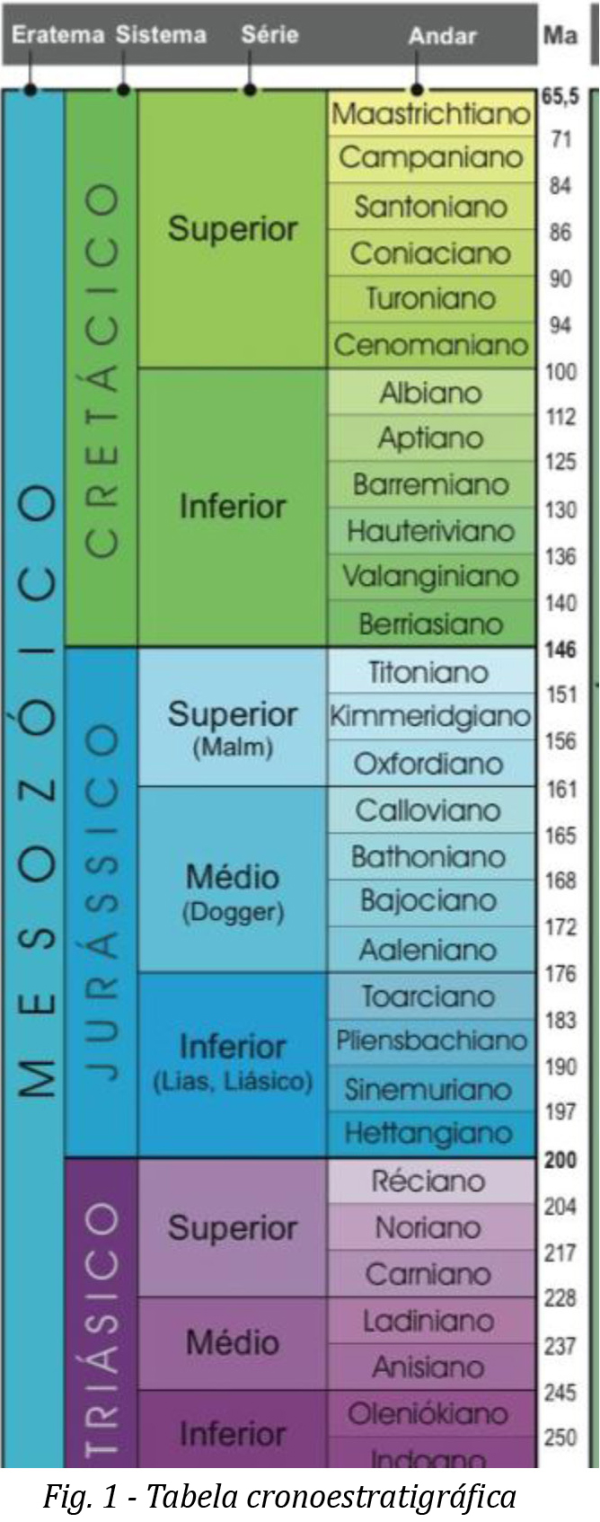
O afloramento compreende uma espessa série de sedimentos marinhos e
fluvio-lacustres que se estendem desde o Toarciano superior até ao
Titoniano.
(ver tabela cronoestratigráfica – http://paleoviva.fc.ul.pt/Paleogeofcul/Apoio/cronogeofcul2.pdf
).
Data
de 1994 a entrega, no Instituto de Conservação da Natureza (ICN),
do Relatório de Fundamentação Científica para a classificação do
Cabo Mondego como Monumento Natural. Nesse relatório defende-se o
valor científico e pedagógico de relevância internacional. O valor
científico foi reforçado pela União Internacional de Ciências
Geológicas em 1996 quando foi estabelecido na praia da Murtinheira
(afloramento ocidental da Serra da Boa Viagem) o estratotipo de
limite (GSSP- Global Boundary Stratotype Section and Point) do
andar Bajociano.
Estratotipo é uma
camada de material sedimentar que devido às características que
possui, é considerada a nível internacional como a mais
representativa de um determinado intervalo de
tempo.
http://estpal08.blogspot.com/2008_10_01_archive.html
Mas o processo de classificação do Cabo Mondego não registou
qualquer avanço durante os anos subsequentes apesar de, em 2000 e
por resolução do Conselho de Ministros, o Cabo Mondego ser inserido
na Rede Natura 2000. Já em 2002, a Câmara Municipal da Figueira da
Foz delibera a aprovação do projecto de classificação do Cabo
Mondego como Monumento Natural e em 2003 a sua Assembleia Municipal
aprova a sua classificação como Imóvel de Interesse
Municipal.
Só no dia 6 de Junho de 2007, no âmbito das comemorações do Dia
Mundial do Ambiente, o Governo, em Conselho de Ministros aprova o
Decreto Regulamentar de criação do Monumento Natural do Cabo
Mondego.
Henriques, Maria Helena; Cabo Mondego, Monumento
Natural, Revista Geonovas 21 (2008)
Cabo Mondego, Património Natural,
publicação com o apoio da Câmara Municipal
da Figueira da Foz e Liga dos Amigos de Conimbriga
Cabe-nos a nós o dever de preservar este magnífico Monumento
Natural!
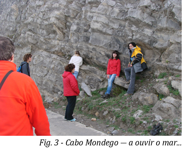
Aprecie com especial atenção todos os pormenores que o cabo Mondego
lhe oferece no passeio que vai fazer para chegar às coordenadas da
earthcache, a grandeza dos estratos a recordar a imensidão dos
tempos geológicos, os fragmentos margosos com registos fósseis a
lembrar ambientes de milhões de anos, a inclinação das rochas
reveladora das forças tectónicas, e sinta a força do mar a ecoar
das vertentes rochosas...
Como reclamar o found:
No local das coordenadas deve virar-se para norte e calcular a
inclinação dos estratos do afloramento que lhe fica em frente
(quanto mede o ângulo formado pelos estratos e o solo
– em graus?)
Importante:
Para poder logar deve enviar a resposta para o meu mail.
The Jurassic of Cabo
Mondego
The Cabo Mondego is a true book of Geological History of the Jurassic
period, between 185 and 120 M. A. (million years). “Route of
Jurassic” is a set of
earthcaches that will give you the opportunity to "live" in
the days when the Megalosaurs walk over
this coast,
to see different
paleoenvironments, understand the marine
transgressions and regressions in this
area, examine the sediment formations,
observe many
records fossils,
and finally to feel a super-ancient treasure. A unique treasure that
we have at our
disposal and that
is all of us.
Take special
care to preserve the
environment - if you want to take
home some
souvenir (rocks, fossils,
etc.). Take it
to the
camera /
GPS or mobile
phone.
And if you
bring a plastic
bag, make a CITO (cache in trash out)!
Along the cliffs to the beaches
of Cabo Mondego there is the largest outcrop
of the Jurassic of Europe, under exceptional
circumstances. The sediments of marl, limestone and sandstone are arranged
along the
coast from the
beach Murtinheira
(Lower and
Middle Jurassic) to the Bay
of Buarcos (Upper Jurassic). The
Cabo Mondego
is an
unrepeatable and
irreplaceable testimony of the geological
history of the
Earth between 185 and 120 Ma (million years).
The outcrop
comprises a
thick series
of marine
sediments and
fluvial-lacustrine extending
from the
upper Toarcian
to the
Tithonian.(fig.1)
In 1994 it was delivered at the Institute for Nature Conservation
(ICN), the Report of Scientific Evidence for classifying the Cabo
Mondego as a Natural Monument. This
report argues the scientific and educational value of international
significance. The scientific value has been reinforced by the
International Union of Geological Sciences in 1996 when was
established in the beach Murtinheira (outcrop west of the Serra da
Boa Viagem) the boundary stratotype (GSSP-Global Boundary
Stratotype Section and Point) Bajocian floor.
Stratotype is
a layer
of sedimentary material due to the characteristics that it possesses; it is
regarded internationally as the most
representative of
a particular
time interval.
But the process of
classification of
Cabo Mondego has
not suffered any progress during the subsequent years
until 2000 and in
this year the Council of Ministers included the Cabo Mondego in
Natura 2000 by a resolution. In 2002,
the Municipality
of Figueira da
Foz approved the
project classification of Cabo
Mondego as a Natural Monument and
in 2003
the Municipal
Assembly approved its classification as a
public property for the City.
Only on June 6, 2007, as part
of the celebrations of World Environment Day, the Government, the Council of
Ministers approved the Decree of creation of the Natural
Monument of Cabo Mondego.
It depends on us
the, and it is
individual our responsibility, to preserve this magnificent natural monument!
Enjoy with special attention
every detail Cabo Mondego gives you in
the ride that
you are going to do till you get the coordinates
of earthcache,
the immensity of
the strata to remember the vastness of geological time, the marl fragments with the fossil record
to remind
environments millions of
years, the slope of the rocks reveals
the tectonic
forces, and feel
the force of the
sea echoing rocky
slopes (fig.3) ...
How to claim your
found:
In local
coordinates must
turn to
the north and
calculate the
slope of
the strata outcrop that lies
ahead (measured as
the angle formed
by strata and soil - in degrees)
Important: Before
logging your found please send the reply to my email.
