------------------------------------------------------------------
But please be advised not to go there without:
- telling somebody where you want to go!
- taking enough water with you!
(in summertime it has 45-50°C and inside the salt dome about 60-65°C)
- any experience in mountain hiking!
- to be sure the driver waits for you!
ولكن نرجو أن تكون نصحت بعدم الذهاب الى هناك دون :
-- يقول أحدهم حيث تريد أن تذهب!
-- أخذ كمية كافية من الماء معك!
(في الصيف فقد 45-50 درجة مئوية ، وداخل قبة الملح حول 60-65 درجة مئوية)
-- أي خبرة في تسلق الجبال!
-- للتأكد من أن السائق ينتظر لك!
From the given coordinates you just hike to north to enter the salt dome!
من أعطاك رفع إحداثيات فقط الى الشمال من دخول قبة الملح
------------------------------------------------------------------
Introduction
These diapirs, domes and glaciers are very great and contain many beautiful landscapes.
هذه diapirs والقباب والأنهار الجليدية هي كبيرة جدا وتحتوي على العديد من المناظر الطبيعية الخلابة.
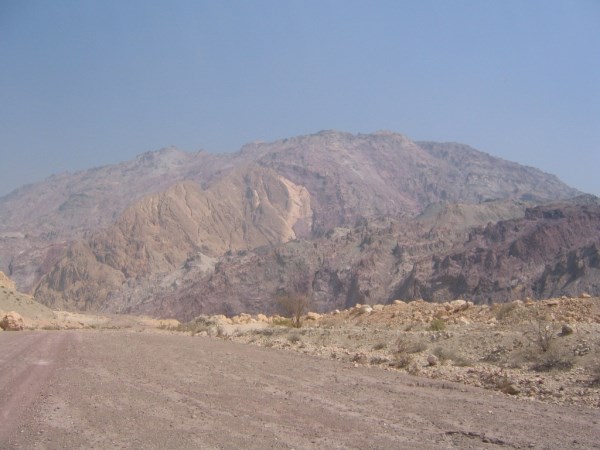
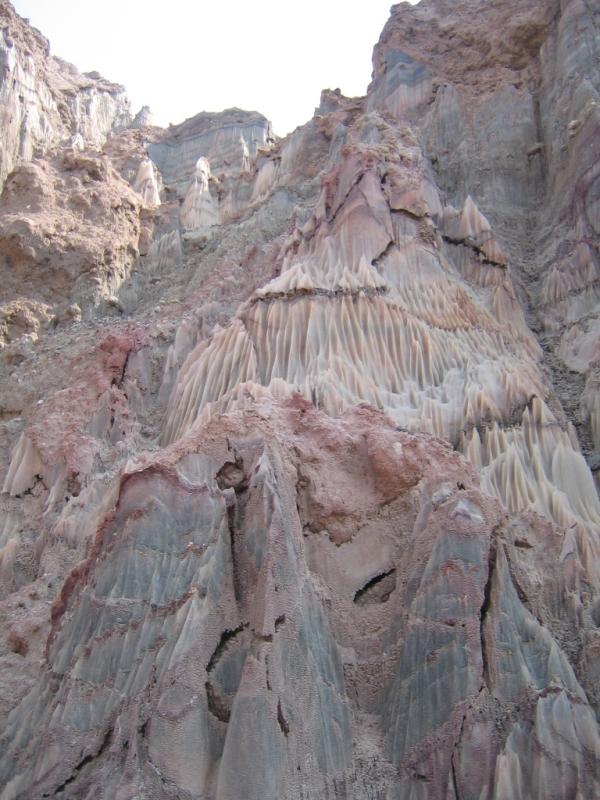
Pic. 1: The salt dome near Anguru.
Iran is located on northern hemisphere, in Middle East area. Iran contains the Alborz mountain belt in north, the Zagros mountain belt in south and the Central Mountains in the centre of the Iran.
وتقع ايران في نصف الكرة الشمالي ، في منطقة الشرق الأوسط. ايران يحتوي على حزام جبال البرز في الشمال ، وجبل زاغروس في الجنوب وحزام جبال الوسطى في وسط ايران.
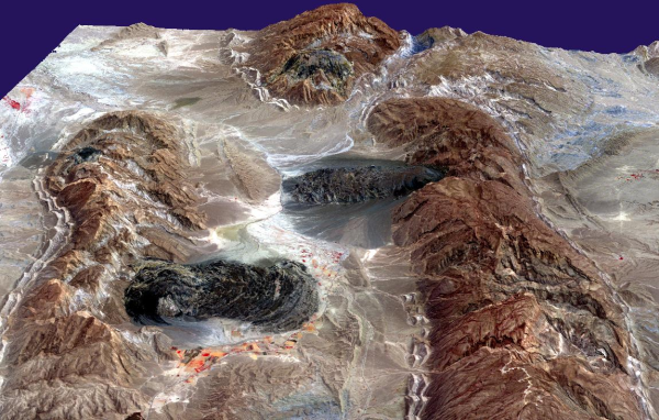
Pic. 2: Zagros salt glaciers (dark). [Image courtesy NASA/GSFC/MITI/ERSDAC/JAROS, and U.S./Japan ASTER Science Team]
114 salt domes are outcropped in the Zagros mountain belt in southwest of Iran. These salt plugs and diapirs are located in the east of Kazerun-Burazjan fault and are known as Hormuz formation. A 14 km thick sedimentary succession is decoupled from crystalline basement by the thick Hormuz complex (Cambrian). The complex consists “Hormuz salt” (by the way: salt is also a stone) together with marls, sandstones, carbonates and volcanic rocks and is known from emergent salt diapirs in the Fars and High Zagros areas. During geological times the Hormuz complex moved up from deeper zones to surface by tectonic movements.
The earliest phase of mobilization of the Hormuz salt occurred in the pre-Silurian. Later pulses of salt movement took place during Triassic times and during ophiolite obduction onto the NE Arabian plate margin in the Late Cretaceous.
و القباب الملحية 114 في حزام جبال زاغروس في جنوب غرب ايران. وتقع هذه المقابس الملح وdiapirs في شرق الخطأ ويعرف تشكيل هرمز. غير المنفصلة كم خلافة الرسوبية السميكة من القبو البلورية بواسطة مجمع هرمز سميكة (الكمبري). ويتكون المجمع "هرمز الملح" (بالمناسبة : الملح هو أيضا حجر) مع والحجر الرملي ، وكربونات الصخور البركانية وكما هو معروف من الملح diapirs الناشئة في المناطق العليا وفارس زاغروس. خلال أوقات الجيولوجية المعقدة انتقلت هرمز يصل إلى مناطق أعمق من السطح من قبل الحركات التكتونية.
حدث في أقرب مرحلة تعبئة الملح هرمز في مرحلة ما قبل السيلوري. تولى في وقت لاحق من البقول حركة الملح مكان في أوقات العصر الترياسي وخلال ophiolite على طبق NE الهامش العربي في أواخر العصر الطباشيري.
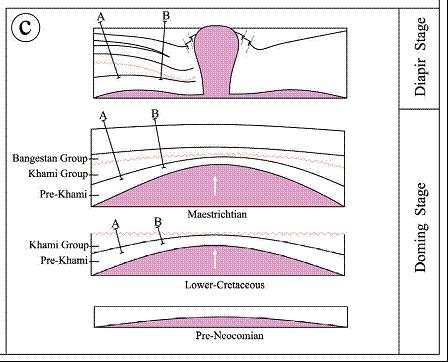
Fig. 1: How a diapir comes to the surface!
Salt glacier and salt falls is another phenomenon of the Iran diapirs. White and salty falls that contain salt crystals are unique in Iran geology fields.
الملح الجليدية ويندرج الملح هو ظاهرة أخرى من diapirs ايران. يقع بيضاء والمالحة التي تحتوي على بلورات الملح هي فريدة من نوعها في مجالات الجيولوجيا ايران.
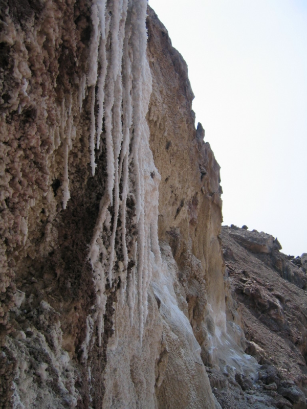
Pic. 3: Salt falls inside Anguru salt diapir!
The Iran diapirs shine in many different colors (to log the cache you sent me pictures of three different coloured salts ant tell what you think which minerals makes these colors ).
الملح، وأملاح اللون وجود كثير من المعادن مثل البايرايت، الهيماتيت، وفلوريت في المقابس الملح يجعل diapirs إيران يلمع في ألوان مختلفة كثيرة (الضوء الأزرق، والضوء الأخضر، والضوء البرتقالي).
Pic. 4: Colored salt inside Anguru salt diapir!
More than 200 salt-related structures have been recognized in the southern Iranian Zagros and Persian Gulf areas.
وقد اعترف أكثر من 200 من الملح هياكل زاغروس في جنوب ايران ومناطق الخليج الفارسي.
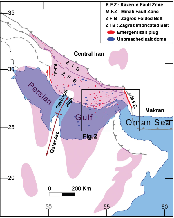
Fig. 2: Overview of the Hormuz complex with emergent Hormuz salt diapirs in the Zagros and Persian Gulf marked.
The box marks the area of Fig. 3.
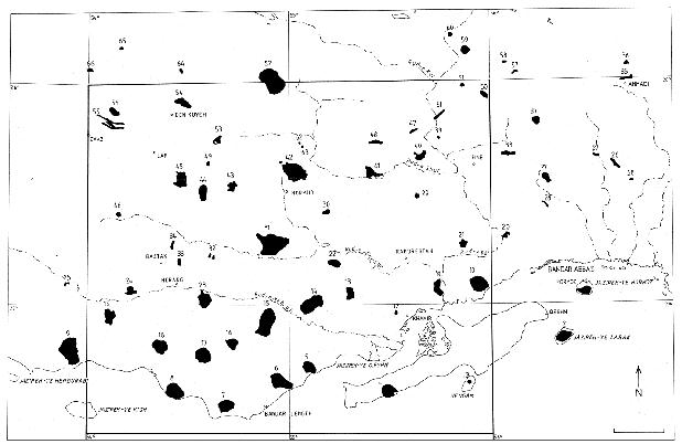
Fig. 3. Location map of emergent Hormuz salt plugs in the SE Zagros and Persian Gulf.
Detailed information for the spot Anguru
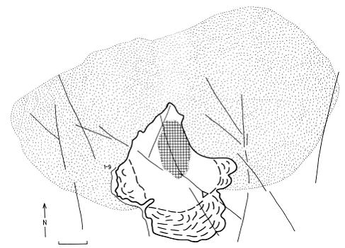
Fig. 4: Sketch of the Unguru plug
Morphological characteristics:
Max. Length: 5 km, Max. Width: 4 km, (Fig. 3: Point 21)
كحد أقصى. مدة العرض : 5 كم، وماكس. العرض : 4 كم ، (الشكل رقم 3 : نقطة 21)
The core of highly active plug lies in its northern segment with maximum elevation of 1,050 m a.s.l. The plug proper is fan-shaped, open to the S. The lowest part in the S is built of glacier at 150 m a.s.l. Glacier movements induce noise effects (quakes). The total height difference is about 600 m. Slightly vaulted summit plateau lies at 900 to 1,000 m a.s.l. continuously passing into leveled surface on Tertiary sediments in the NE. Numerous karst depressions were observed. The marginal plug rim reaches about 1,600 m a.s.l. and has extremely large diameter (nearly 15 km).
جوهر المكونات النشطة للغاية يكمن في جزئه الشمالي مع الارتفاع الأقصى من 1050 م قابس الصحيح هو على شكل مروحة، مفتوحة للS. بنيت في أدنى جزء من الجبل الجليدي S 150 م في الحركات الجليدي إحداث تأثيرات الضجيج (الزلازل). الفرق ارتفاع إجمالي حوالي 600 متر. قليلا مقبب قمة هضبة تقع في 900 إلى 1000 متر تمر باستمرار الى سطح جهت اليه في الرواسب العالي في الشرق الأدنى. وقد لوحظت العديد من المنخفضات الكارستية. حافة المكونات الهامشية تصل إلى حوالي 1600 متر وقطرها كبير للغاية (ما يقرب من 15 كم).
Hydrological characteristics:
The summit plateau is areally drained. Drainage basin between the plug s.l. and the cauldron has a circular character. General southward drainage empties to Rud-e Kul. No springs were detected inside the plug or cauldron. Relatively large springs are situated nearby in the southern flanks (contact of Asmari and Gachsaran Formations).
ينضب قمة الهضبة. حوض الصرف بين المكونات s.l. والمرجل له طابع دائري. عام يفرغ الصرف جنوبا رود الإلكتروني كول. تم الكشف عن أي الينابيع داخل التيار أو المرجل. وتقع الينابيع الكبيرة نسبيا القريبة في الجناحين الجنوبي (الاتصال والتشكيلات الأسمري).
Regional geological position:
The more steep southern flank of the Anguru Anticline, its central zone. Nearly the complete earth time scale unit (see Fig. 5 for stratigraphic sequence) is present. Photolineations of the NNW-SSE, NNE-SSW and NESW direction dissect in the plug and in its surroundings, forming complicated knot.
مزيد من الجهة الجنوبية من حاد تقابل الانحدار، منطقتها المركزية. ما يقرب من الساعة وحدة الأرض كاملة النطاق (انظر الشكل رقم 5 لتسلسل الطبقي) هو الحاضر. من NNW - SSE، NNE - SSW والتوجيه NESW تشريح في قابس والمناطق المحيطة بها، وتشكيل العقدة تعقيدا.
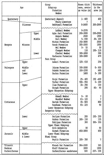
Fig. 5: Review of stratigraphy sequence (Phanerozoic).
Petrological characteristics:
The plug is built mostly by evaporitic (the water evaporates and leaves back the sediments) sediments. Greenish salt dominates over gypsum. Blocks of sediments and magmatites are enclosed in them. Sediments (slightly metamorphosed) are represented mostly by reddish brown shales and siltstones, less frequently by dark gray to black slightly graphitic shales.
تم بناء سد في الغالب evaporitic (الماء يتبخر ويترك الظهر الرواسب) الرواسب. الملح الأخضر يسيطر على الجبس. يتم تضمين كتل من الرواسب وmagmatites فيها. تمثل الرواسب (مغيرة قليلا) معظمهم من السجيل البني المحمر وsiltstones، وأقل كثيرا من قبل الرمادي الداكن إلى الأسود السجيل غرافيتي قليلا.
References:
- Pavel BOSÁK1, Josef JAROŠ2, Jiøí SPUDIL3, Petr SULOVSKÝ4 and Vladimír VÁCLAVEK5: Salt Plugs in the Eastern Zagros, Iran: Results of Regional Geological Reconnaissance
- H. Motamedi, M. Sepehr, S. Sherkati and M. Pourkermani: MULTI-PHASE HORMUZ SALT DIAPIRISM IN THE SOUTHERN ZAGROS, SW IRAN
For a bigger map of the location please follow link below!
Topographic map of the spot!
To log the cache you have to:
- send me some pictures showing your gps a/o optional you by or inside the salt diapir!
- Tell me what different colours of the salt you can discover (optional sending pictures showing the different colors of the salt) and what you guess whitch minerals make the salt shine colored like this!
PLease before you log this cache you have to wait for our permission!
لتسجيل ذاكرة التخزين المؤقت لديك :
-- ترسل لي بعض الصور تظهر GPS الخاص بك / س لك من قبل أو داخل diapir الملح!
-- قياس درجة حرارة سطح الأرض والهواء داخل القبة
-- العثور على شجرة صغيرة في الطريق من طرق الشمال الشارع الى قبة وتقول لي ما هو محفور في ذلك (لا يوجد سوى عدد قليل شجرة وهنا يمكنك ان تجعل من الراحة والاستمتاع الظل)
H A P P Y – G E O C A C H I N G !