Baviaanskloof Breakfast Break
The Cache
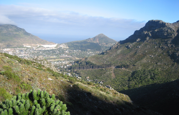
This cache is located approximately 60 minutes hike up from the East Fort end of the trail and has fine views down Baviaanskloof, down the Hout Bay river valley (aka the Disa or Palmiet river which flows down from Table Mountain Back Table via Orange Kloof) towards Sandy Bay Nek and Little Lion's Head, and across to the cliffs and ledges of Skoorsteenberg (551m). There are some nice flat rocks nearby and this combined with the timing up from East Point (and seasonal water in the kloof) makes it an ideal spot for a breakfast break before continuing along the trail.
The cache, a camo-taped tablet pot, is hidden just off the upper side of the trail.
The Trail
This is one of a series of caches along this great route between East Fort and Constantia Nek which were placed to encourage more geocachers & their muggle friends to visit this part of the Cape Peninsula . . . and to make the worthwhile detour to explore the spectacular ledges of Skoorsteenberg.
There are several point of access to the trail but the three main starting points are:
1. East Fort parking area @ S 34° 03.297 E 018° 21.889
2. Constantia Nek parking area @ S 34° 00.680 E 018° 24.320 (head for the start of the Vlakkenberg trail about 400m down the Hout Bay road from the restaurant car-park)
3. Silvermine parking area @ S 34° 04.516 E 018° 24.055
(The trail can also be accessed near its middle section from Bokkemanskloof (parking at the top end of Blue Valley Avenue near S 34° 01.432 E 018° 22.996) or from Tokai Plantation. Another route accessing towards the Constantia end runs up Vlakkenberg Ridge - parking at the end of Price Drive @ S 34° 01.464 E 018° 24.812)
The main trail is part of the 4-day Hoerikwaggo Hiking Trail which runs from Table Mountain to Cape Point – see http://www.hoerikwaggotrail.org/map/hoerikwaggo-trail.html for more information.
The side trail to Skoorsteenberg is a well established track marked in less distinct areas by regular cairns. All trails are well-visible on Google Earth and marked on the relevant Slingsby map – Hout Bay & The Constantia Winelands.
The easiest way to do the route (and detour) is to leave a car at each end and then walk from one to the other. It is something like12km and will take around 6 hours to complete (+ cache time!) Water may be available en route where the trail crosses Baviaanskloof near this cache location (runs dry in summer) and in the marshy area under the boardwalk section above Bokkemanskloof @ S 34° 01.812 E 018° 23.429 (still running when the cache was placed).