Eyes of the Sahara (El Richat) EarthCache
Eyes of the Sahara (El Richat)
-
Difficulty:
-

-
Terrain:
-

Size:  (not chosen)
Please note Use of geocaching.com services is subject to the terms and conditions
in our disclaimer.
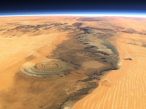
 The 50 kilometers in diameter geological formation, made up of
concentric circles, is one of those forms clearly discernible both
from the ground and from space. The formation is noticeable thanks
to Sahara desert, which covers a large area of the northwest
African country of Mauritania; the sand of the desert contrasts
against the crystalline rocks of this geological formation. The
scientific community has still not reached consensus regarding how
Richat Structure formed. Due to its large, circular shape and
symmetry, it was thought at first that a meteor impact created it,
but this is negated by the flat bottom of the crater, and the fact
that signs that would justify such a powerful impact are missing
have not been found in the Sahara desert. The most supported theory
asserts that the structure formed through the erosion of a young
volcanic cone, which after rising several thousands years ago, was
worn down by the water and wind.
The 50 kilometers in diameter geological formation, made up of
concentric circles, is one of those forms clearly discernible both
from the ground and from space. The formation is noticeable thanks
to Sahara desert, which covers a large area of the northwest
African country of Mauritania; the sand of the desert contrasts
against the crystalline rocks of this geological formation. The
scientific community has still not reached consensus regarding how
Richat Structure formed. Due to its large, circular shape and
symmetry, it was thought at first that a meteor impact created it,
but this is negated by the flat bottom of the crater, and the fact
that signs that would justify such a powerful impact are missing
have not been found in the Sahara desert. The most supported theory
asserts that the structure formed through the erosion of a young
volcanic cone, which after rising several thousands years ago, was
worn down by the water and wind.
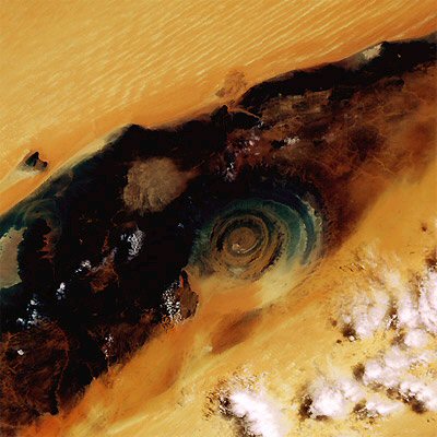
The concentric circles represent various layers of the volcanic
dome, of different hardness: the circles are made of crystalline,
six million years old, strong quartzite, while the valleys lying
between them consist of weaker rocks, which eroded faster. There
are some who still believe in the theory of the meteorite impact -
thanks in part to the fact that some parts of the eye are located
500 meters below sea level - and there are others who came forward
with completely different explanations. Among the latter are those
who believe that the Richat Structure resembles similar formations
created by underground nuclear explosions. The explosion, however,
in this case must be very powerful, and today no country has
weapons whose destructive power comes even close to achieve such
results. Apart from sunsets and the particular color of the sand
dunes, the Richat Structure became one of the most popular tourist
destination in Mauritania; the formerly barren landscape started to
be increasingly populated due to the influx of adventurous
travelers. Local businesses organizing trips laid out roads to
traverse the area, sometimes even trails which deviate from the
normal route, specifically to please the most daring visitors. A
peculiarity of the structure is a small hotel located right in the
middle, which does not offer the much luxury, but is an ideal
choice for fans of futuristic locations.
The region is at least as interesting as the eye itself, 100 miles
south from it the world's largest iron mine is located, the railway
of which is a real curiosity. The 674-kilometer long line used for
transporting the extracted ore is the world's longest non-stop
railroad. The trains themselves also set a world record, the line
of cars has a length of almost three kilometers. There are also
perfect destination for the lovers of remarkable natural treasures:
the canyons of Passe d'Amogjar, and Fort Saganne, famous for its
prehistoric paintings, also attract countless travelers, and so
does the Tergit oasis near Atar. The desert is rife with medieval
ksourts, that also mean stronghold, now part of the World Heritage.
The ksourts are villages that were built during the middle ages,
consisting of towers, town walls and houses, scattered along the
main trade routes of the Sahara. The Mauritanian ksourts became a
World Heritage site in 1996. In terms of climate, the best time to
visit the area is between November and March. From Nouakchott
airport there are two day trips to Richat Structure.
Not far from here, in northwest direction there is Mauritania's
highest point, Kediet ej Jill, 915 meters above the sea level; the
mountain contains large quantities of magnetite. Due to its
magnetic properties, traditional compasses go completely
haywire.
Structure:
The Richat structure appears as a large dome at least 40 km in
diameter within a Late Proterozoic (1000-542 million years ago) to
Ordovician (Early Paleozoic, 488.3-443.7 million years ago)
sequence. Erosion has created circular slopes represented by three
nested rings dipping outward from the structure. The center of the
structure consists of a limestone-dolomite shelf that encloses a
kilometer-scale siliceous breccia (debris rocks) and is intruded by
basaltic ring dikes, kimberlitic intrusions, and alkaline volcanic
rocks. Several hypotheses have been presented to explain the
spectacular Richat structure and breccia, but their origin remains
enigmatic. The breccia body is lenticular in shape and irregularly
thins at its extremities to only a few meters. The breccia was
created during karst dissolution and collapse. Internal sediments
fill the centimeter- to meter-scale cavities. Alkaline enrichment
and the presence of Cretaceous K-feldspar demonstrate the
hydrothermal origin of these internal sediments and their
contemporaneity with magmatism. A model is proposed in which doming
and the production of hydrothermal fluids were instrumental in
creating a favorable setting for dissolution. The circular Richat
structure and its breccia core thus represent the superficial
expression of a Cretaceous alkaline complex with an exceptionally
well preserved hydrothermal karst infilling at its summit.

To log yor visit, please.
Send your answer via e-mail to me...
Please don’t give answer in your log !
Examine a rock within the circle, write down the properties of
(color, shape and texture...), what do you think what origin
(volcanic, sedimentary or metamorphic) !
Optionally, you can upload photos of yourself and the circle, and
also note the exact coordinates of the photographs !
Thank you for the english translation
Dj Storm !
-----------------------------------------------------------------------
 Le 50 km en formation géologique de diamètre,
composé de cercles concentriques, est l'une de ces formes
clairement perceptible à la fois du sol et de l'espace. La
formation est perceptible grâce au désert du Sahara, qui couvre une
vaste zone au nord-ouest du pays africains de la Mauritanie, et le
sable du désert contraste avec les roches cristallines de cette
formation géologique. La communauté scientifique n'a pas encore
parvenus à un consensus sur la façon dont la structure Richat
formé. En raison de sa grande forme circulaire et de symétrie, on a
pensé d'abord que impact d'une météorite a créé, mais cela est nié
par le fond plat du cratère, et le fait que les signes qui
justifierait un tel impact sont manquantes n'ont pas été trouvé
dans le désert du Sahara. La théorie la plus soutenue affirme que
la structure formée par l'érosion d'un cône volcanique jeunes, qui
après avoir augmenté de plusieurs milliers d'années auparavant, a
été porté par l'eau et le vent.
Le 50 km en formation géologique de diamètre,
composé de cercles concentriques, est l'une de ces formes
clairement perceptible à la fois du sol et de l'espace. La
formation est perceptible grâce au désert du Sahara, qui couvre une
vaste zone au nord-ouest du pays africains de la Mauritanie, et le
sable du désert contraste avec les roches cristallines de cette
formation géologique. La communauté scientifique n'a pas encore
parvenus à un consensus sur la façon dont la structure Richat
formé. En raison de sa grande forme circulaire et de symétrie, on a
pensé d'abord que impact d'une météorite a créé, mais cela est nié
par le fond plat du cratère, et le fait que les signes qui
justifierait un tel impact sont manquantes n'ont pas été trouvé
dans le désert du Sahara. La théorie la plus soutenue affirme que
la structure formée par l'érosion d'un cône volcanique jeunes, qui
après avoir augmenté de plusieurs milliers d'années auparavant, a
été porté par l'eau et le vent.
Les cercles concentriques représentent les différentes couches du
dôme volcanique, de dureté différente: les cercles sont en
cristallin, six millions d'années, quartzite forte, tandis que les
vallées situées entre eux consistent en des roches les plus
faibles, ce qui a érodé plus rapide. Il ya ceux qui croient encore
à la théorie de l'impact d'une météorite - en partie grâce au fait
que certaines parties de l'œil sont situés à 500 mètres sous
le niveau de la mer - et il y en a d'autres qui se sont présentés
avec des explications complètement différentes. Parmi ceux-ci sont
ceux qui croient que la structure Richat ressemble formations
similaires créés par les explosions nucléaires souterraines.
L'explosion, cependant, dans ce cas doit être très puissant, et
aujourd'hui aucun pays ne possède des armes de destruction dont la
puissance vient même près de parvenir à ces résultats. En dehors de
couchers de soleil et de la couleur particulière des dunes de
sable, la structure de Richat est devenu une des destinations
touristiques les plus populaires en Mauritanie, le paysage
autrefois stériles ont commencé à être de plus en plus peuplées, en
raison de l'afflux de voyageurs aventureux. Les entreprises locales
l'organisation de voyages établies des routes à parcourir la
région, parfois même des pistes qui s'écartent de la voie normale,
en particulier pour s'il vous plaît les visiteurs les plus
audacieux. Une particularité de la structure est un petit hôtel
situé en plein milieu, ce qui n'offre pas le grand luxe, mais est
un choix idéal pour les amateurs de lieux futuriste.
La région est au moins aussi intéressant que l'œil lui-même,
à 100 miles au sud de la mine qu'il mondial de fer se trouve, le
chemin de fer qui est une véritable curiosité. La ligne
674-kilomètre de long utilisé pour le transport du minerai extrait
est le plus long du monde de chemin de fer non-stop. Les trains
eux-mêmes a aussi établi un record du monde, la file de voitures a
une longueur de près de trois kilomètres. Il ya aussi une
destination idéale pour les amoureux de remarquables trésors
naturels: les canyons de Passe d'Amogjar, et Fort Saganne, célèbre
pour ses peintures préhistoriques, attirent également les voyageurs
innombrables, et ainsi ne l'oasis Tergit près d'Atar. Le désert est
truffé de ksourts médiévale, qui signifie aussi forte, qui fait
maintenant partie du patrimoine mondial. Le ksourts ya des villages
qui ont été construits pendant le moyen âge, composé de tours, des
remparts et les maisons, disséminées le long des principales routes
commerciales du Sahara. Le ksourts mauritanien est devenu un site
du patrimoine mondial en 1996. En termes de climat, le meilleur
moment pour visiter la région est entre Novembre et Mars. De
l'aéroport de Nouakchott, il ya deux journée de la Richat
Structure.
Non loin de là, au nord-ouest direction il est le point culminant
de la Mauritanie, Kediet ej Jill, 915 mètres au-dessus du niveau de
la mer, la montagne contient de grandes quantités de magnétite. En
raison de ses propriétés magnétiques, compas traditionnels vont
complètement détraqué.
Structure:
La structure de Richat apparaît comme un grand dôme au moins 40 km
de diamètre dans un néoprotérozoïques (1000 à 542 millions
d'années) à l'Ordovicien (Paléozoïque inférieur, de 488,3 à 443.7
millions d'années) de séquence. L'érosion a créé pistes
circulaires, représenté par trois anneaux imbriqués pendage vers
l'extérieur de la structure. Le centre de la structure se compose
d'un plateau calcaire et la dolomie qui renferme une brèche
d'échelle kilométrique siliceux (roches débris) et est recoupée par
des dykes basaltiques anneau, intrusions kimberlitiques et des
roches volcaniques alcalines. Plusieurs hypothèses ont été avancées
pour expliquer la structure de Richat spectaculaire et de la
brèche, mais leur origine reste énigmatique. Le corps brèche est
lenticulaire s'amincit forme irrégulière et à ses extrémités à
seulement quelques mètres. La brèche a été créé lors de la
dissolution karstique et de l'effondrement. Sédiments interne
remplir les cavités centimètre à l'échelle métrique. Enrichissement
alcalines et la présence de Crétacé feldspath potassique démontrer
l'origine hydrothermale de ces sédiments internes et leur
contemporanéité avec le magnétisme. Un modèle est proposé dans
lequel dôme et la production de fluides hydrothermaux ont contribué
à créer un cadre favorable à la dissolution. La structure
circulaire Richat et son noyau brèche représentent ainsi
l'expression superficielle d'un complexe alcalin Crétacé avec un
karst hydrothermal exceptionnellement bien préservé remplissage à
son sommet.
Pour log s'il tu
plaît.
Envoies de réponse à moi par e-mail...
S'il tu plaît ne te donne pas la réponse de ton log !
Examines un rocher dans le cercle, ecris les propriétés (couleur,
la forme et la texture...) que penses-tu quelle origine
(volcaniques, sédimentaires ou métamorphiques) !
En option, vous pouvez
télécharger des photos de vous-même et le cercle, et aussi de noter
les coordonnées exactes des photos !
-----------------------------------------------------------------------

-----------------------------------------------------------------------
 Az 50 kilométer átméroju, koncentrikus
körökbol álló képzodmény egyike azoknak a geológiai formáknak,
melyek az urbol és a Földrol is tisztán kivehetoek, köszönhetoen
részben annak, hogy az északnyugat-afrikai ország, Mauritánia nagy
részét a Szahara uralja, melynek homoktömegével szemben éles
kontrasztot jelentenek a különös színu, kristályos kozetek. A
Richat Structure keletkezését illetoen máig nem jutott megegyezésre
a tudóstársadalom. Nagy kiterjedésu, kör alakja és szimmetriája
miatt eleinte azt gondolták, egy meteor becsapódásának köszönheto
létrejötte, azonban ezt cáfolja a kráter aljának túlságosan lapos
volta, illetve az a tény, hogy a Szaharában másutt nem találtak
olyan nyomokat, melyek igazolnák egy ilyen nagy ereju becsapódás
megtörténtét. A legelfogadottabb elméletek szerint a képzodmény egy
fiatal vulkáni kúp eróziója által jött létre, mely kiemelkedése
után a víz és a szél több ezer éves munkájának köszönhetoen
folyamatosan kopott.
Az 50 kilométer átméroju, koncentrikus
körökbol álló képzodmény egyike azoknak a geológiai formáknak,
melyek az urbol és a Földrol is tisztán kivehetoek, köszönhetoen
részben annak, hogy az északnyugat-afrikai ország, Mauritánia nagy
részét a Szahara uralja, melynek homoktömegével szemben éles
kontrasztot jelentenek a különös színu, kristályos kozetek. A
Richat Structure keletkezését illetoen máig nem jutott megegyezésre
a tudóstársadalom. Nagy kiterjedésu, kör alakja és szimmetriája
miatt eleinte azt gondolták, egy meteor becsapódásának köszönheto
létrejötte, azonban ezt cáfolja a kráter aljának túlságosan lapos
volta, illetve az a tény, hogy a Szaharában másutt nem találtak
olyan nyomokat, melyek igazolnák egy ilyen nagy ereju becsapódás
megtörténtét. A legelfogadottabb elméletek szerint a képzodmény egy
fiatal vulkáni kúp eróziója által jött létre, mely kiemelkedése
után a víz és a szél több ezer éves munkájának köszönhetoen
folyamatosan kopott.
A körvonalakat ennek alapján a vulkáni dóm különféle szilárdságú
kozetei alkotják: a kristályos, hat millió éves, ellenálló kvarcit
alkotja a köröket, a közöttük meghúzódó völgyek pedig a gyengébb
kozetek kopása révén alakultak ki. Vannak, akik még mindig a
meteorbecsapódás tényében hisznek, köszönhetoen részben annak a
ténynek is, hogy a szem egyes részei 500 méterrel a tengerszint
alatt helyezkednek el -, csak úgy, mint olyanok, akik egész más
magyarázattal álltak elo. Utóbbiak közé tartoznak azok, akik
szerint a Richat Structure azokra a képzodményekre hasonlít,
melyeket föld alatti nukleáris robbanások hoztak létre. A
robbanásnak azonban ebben az esetben igen nagy ereju tartományban
kellett volna lennie, a Földön pedig ma egyetlen országnak sincs
olyan fegyvere, melynek ereje ennek a romboló hatásnak akár csak a
közelébe érhetne. A homokdunék különleges világa és a naplementék
mellett mára a Richat Structure lett Mauritánia egyik
legkeresettebb idegenforgalmi célpontja, így a távoli, korábban
kietlen vidéket egyre gyakrabban népesítik be a kalandvágyó utazók.
A környék bejárására a helyi vállalkozások szervezett utakat
terveznek, sokszor olyanokat is, melyek letérnek a megszokott
útvonalról, és kifejezetten a vakmerobb látogatóknak ajánlottak. A
képzodmény egyik sajátossága, hogy egy kis hotel is található a
kellos közepén, mely ugyan nem nyújt luxusszolgáltatásokat, ám
ideális választás a futurisztikus helyek kedveloinek.
A környék is legalább olyan érdekes, mint maga a szem, tole
délkeletre, 100 mérföldre található ugyanis a világ egyik
legnagyobb vasbányája, melynek vasútja is igazi kuriózum. 674
kilométeres vonalon szállítják ugyanis el a kitermelt ércet, ami a
világ leghosszabb, megállók nélküli vonatútjának számít. Maga az
itt közlekedo vonat is hosszúságával állított fel világrekordot, a
kocsisor csaknem három kilométeres. A különleges természeti kincsek
szerelmeseinek szintén tökéletes úti célt jelentenek Passe
d’Amogjar kanyonjai, emellett Fort Saganne híres
prehisztorikus festményei is számtalan utazót vonzanak, csak úgy,
mint az Atar közelében található Tergit-oázis. A homoksivatag
számos, ma már a világörökséghez tartozó középkori ksour-t, azaz
erodítményt is rejt. A ksourok tornyokból, városfalból és házakból
álló, a Szaharán átvezeto fontos kereskedelmi utak mentén álló,
középkorban épült települések. A mauritániai ksourok 1996-ban
váltak a világörökség részévé. A klíma szempontjából a legjobb
november és március között a környékre látogatni. Nouakchott
repüloterérol két nap alatt bejárható maga a Richat Structure
is.
Nem messze innen Északnyugati irányban van Mauritánia legmagasabb
pontja, a 915 m-es Kediet ej Jill. Kozetanyaga magnetit. Mágneses
tulajdonsága miatt itt a hagyományos iránytük megbolondulnak.
Szerkezete:
Richat struktúra úgy jelenik meg, mint egy nagy kupola, legalább 40
km átméroju egy új proterozoikum (1000-542 millio évvel ezelott) és
ordovícium (korai paleozoikum, a 488,3-443.7 millio évvel ezelott)
szekvenciája . Erózió álltal létre hozott körkörös pályák, három
egymásba ágyazott gyuru szerkezet. A központi szerkezet egy mészko
és dolomit fennsík, amely egy kilométer kiterjedésu kovasavas
breccsa (törmelék ko), és bazaltos telérek gyuru kimberlit
behatolások és alkáli vulkáni kozetek. Több hipotézis is létezik, a
Richat szerkezet látványos breccáinak keletkezésére de azok eredete
rejtély. A breccsa test lentikuláris (lencseforma) és szabálytalan
alakú mécsesek végei csak néhány méter. A breccsa során karsztos
oldódás során jött létre és az összeomlás. Belso üledékek töltötte
ki az centiméter méretu üregeket metrikusan. Alkáli gazdagodás és a
Kréta K-földpát jelenléte bizonyítja a hidrotermális eredetét. A
modell javasolt, amely a kupola és a termelés a hidrotermális
folyadékok segítettek kedvezo környezetet teremt a feloszlását. A
kör alakú szerkezete és alapveto megsértésével Richat így azon a
felületes kifejezodése kréta alkáli komplexum egy kivételesen jó
állapotban fennmaradt hidrotermális karszt töltés tetején.
A logoláshoz
kérlek.
Küldd el a választ számomra e-mail -ben...
Kérlek ne adj meg választ a logban !
Vizsgálj meg egy követ a körön belül, írd le a tulajdonságait
(szín, forma. állag...) mit gondolsz milyen eredetu (vulkáni,
üledékes vagy metamorf) !
Kérlek ha van rá
lehetoséged tölts fel fényképet a körrol és magadról, valamint írd
meg a fénykép készítésének pontos koordinátáit !

Additional Hints
(No hints available.)