(SI) Ozka tesen, oziroma v korita stisnjen hudourni potok, pri katerem močnega preoblikovanja zemeljskega površja ni težko doumeti.
PRED ZACETKOM:
Opis tega Geološkega zaklada je dolg. Prosimo, preberite ga in si zapisite naloge za vpis se pred obiskom zaklada!
NALOGE ZA VPIS OBISKA
1. Prav pod opazovalno ploscadjo je 8 meterski slap. Ravno pred slapom voda pada preko nekaksnih skalnih stopnic. Koliko jih je, ce stejete tudi tisto na samem zgornjem robu slapa?
2. Voda je med skalnimi stopnicami nad slapom, s pomocjo kamnitega materiala, ki ga prenasa, ustvarila dva enaki, znacilni geomorfoloski obliki. Opisi ju in poskusi najti pravi izraz zanju.
3. Mlinarica je bila razglasena za naravno znamenitost. Katerega leta? Odgovor lahko poiscete blizu opazovalne ploscadi.
4. Zelo bomo veseli, ce kaksno zanimivo fotografijo s predlaganih tock zaklada prilozite svojemu vpisu (logu) obiska.
POMEMBNO!
- Preden vpisete obisk zaklada, posljite odgovore preko GC profila ali neposredno na e-naslov vane.si.geo@gmail.com. Takoj potem lahko vpisete obisk zaklada na spletu – ne potrebujete dodatnega dovoljenja. Ce ste fotografirali, prosimo, prilozite kaksno fotografijo.
- Vpisi brez ustrezne spremljajoce e-poste, ki vsebuje pravilne odgovore, bodo najprej trajno kodirani, kasneje izbrisani!
- Vpisi, ki vsebujejo odgovor bodo izbrisani!
(ENG) Narrow gorge where a reshaping of the earth surface by torrential stream becomes easily perceptible.
BEFORE THE BEGINNING:
This EarthCache has a long description! Please, read it and write down logging tasks before visiting the EarthCache site!
LOGGING TASKS
1. There is a small, 8 meters-high waterfall just under the observation platform. Just before the waterfall, water cascades over some kind of stone steps. How many, including the one at the beginning of the waterfall?
2. Water erosion, with the help of gravel debris, has formed previously mentioned stone steps above the waterfall. Between those steps are two identical, distinctive geomorphological features. Describe them and try to find the right name for the feature.
3. Mlinarica has been designated an outstanding natural feature. When? You can find an answer near the observation platform.
4. We would be glad if you added interesting photos from one of the EarthCache locations to your log.
IMPORTANT!
- Send answers through GC profile or directly to e-mail vane.si.geo@gmail.com
before logging. After that you can log - you don't need an additional permission to log. Please, upload photos if you have taken them.
- Logs without an accompanying e-mail containing correct answers will be encrypted and later deleted!
- Logs containing the answer will be deleted!
slovensko besedilo / Slovenian text
tocke poti in dnevniki / waypoints and logs
Visit our web-site Geološki zakladi / EarthCaches
for a complete list of our EarthCaches and a lot of additional information.
(ENG) MLINARICA TROUGHS
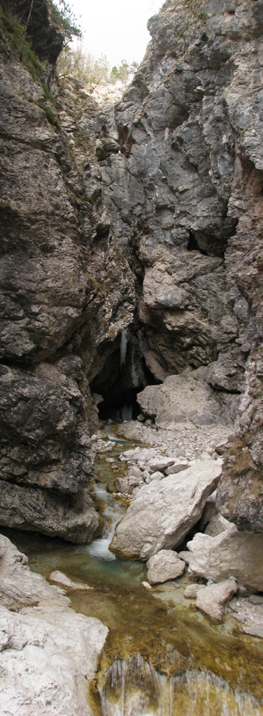
Mlinarica is situated in the uppermost part of Soca river valley. Mlinarica gorge lies hidden between mountains Prisojnik and Razor. Stormy brook Mlinarica is supplied by mountain snow field. Gorge is fettered between rocks of Kukla mountain and is almost unseen when it flows out to Soca river. Brook has excavated one kilometer long and 100 meters deep gorge, which is narrowed in unique water channel, before confluence with the Soca river. The narrowest parts of gorge are only one meter wide. In several places wedged-in rocks form natural bridges. Brook Mlinarica fall is considerable - full 300 meters in just 700 meters length. There are many waterfalls and pools in the inner part of the water channel, accessible with special climbing equipment only.
The lower part of Mlinarica troughs is accessible for tourists too. There is an observation platform from which you can get a hint of what lies behind curves of the narrow gorge. You can also see some of the characteristically karstic features carved in the stone by water.
HISTORY AND GEOLOGY
There have been many ice-ages with warmer intermediate periods in the last few hundred thousand years. The last ice-age ended only 10.000 years ago. Each ice-age was a time of intense mechanical rock-weathering. Glaciers caused significant changes of the Earth surface, which is also visible in the valleys they have filled.
Before glaciation, Soca river valley has not been so deep in comparison to surrounding mountains. The shape of the valley has also been much sharper - characteristically V shaped, produced by downward erosion by water. During each glaciation, glacier has deepened Soca river valley more than its tributary Mlinarica. When the glacier receded, water of Mlinarica slowly, but inevitably, carved narrow gorge which has also deepened after each glaciation.
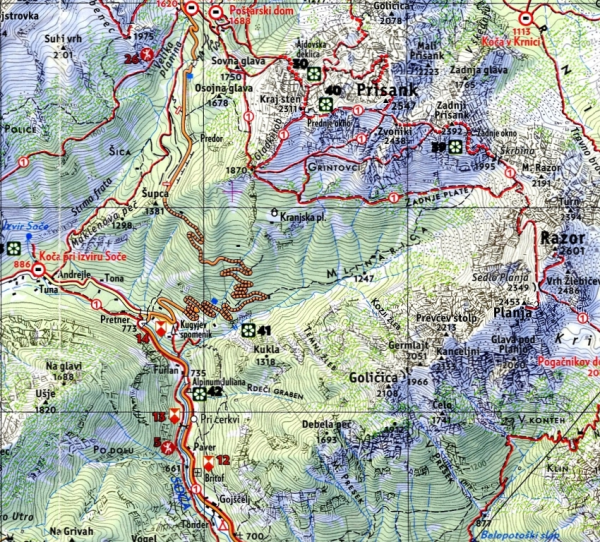
Figure 1:
Mlinarica and surroundings. Clipping of Mountaineering map Julian Alps, Sidarta, 2009
Slopes of Kukla mountain, Golicica, Planja and Razor form southern part of Mlinarica drainage area and Prisojnik (Prisank) its northern part. At the clipping of the geological map, you can see that Prisojnik is built of dolomite while Golicica and other hills South of Mlinarica are made of limestone. Since limestone is more soluble in the water and weak acid solutions than dolomite, Mlinarica excavated gorge at the edge of dolomite – in the limestone.
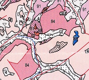
Figure 2:
Upper Soca river valley with Mlinarica and surroundings. Clipping of Geological map of Slovenia, Geological Survey of Slovenia, 2009
Rock formations of Mlinarica and surroundings:
84: Massive coarse-crystalline dolomite and limestone; Upper Triassic – Cordevol (ca. 220 million years);
83: Alternation of claystone and sandstone in the upper part – Amphiclina beds; Upper Triassic – Carnian (ca. 220 million years);
81: Platty limestone and dolomite with chert, marlstone, marly limestone – Tamar formation; Upper Triassic – Carnian (ca. 220 million years);
76: Thick-bedded Dachstein Limestone with transiton to dolomite; Upper Triassic – Norian, Rhaetian (ca. 210 million years);
75: Reef limestone with corrals; Upper Triassic –Rhaetian (ca. 200 million years);
14: Quarternary – Pleistocene: Till, moraine;
EARTHCACHE AND ACCESS
1. OBLIGATORY PART
OBSERVATION PLATFORM...
... is where the coordinates of the Earthcache are set. Park your car at waypoint PARK1. Follow signposts along short, easy trail with footbridge across Soca river. You will reach Earthcache in few minutes. Forces that shape the surface of the Earth have shown their strength there too. The old wooden bridge has been built some 30m further in the gorge than observation platform today. In 1999 torrential waters of the severe thunderstorm demolished bridge. New bridge has been built at the same place only to await new destruction. This time it has been collapse of the part of gorge's stone wall - huge rocks demolished the bridge in 2005. New platform has been built in 2007, at safer spot, just outside of the gorge.
Trail to Mlinarica is public, accessible all the year round, except in the time of thick snow. There is no entrance fee.
2. OPTIONAL PART, NOT OBLIGATORY
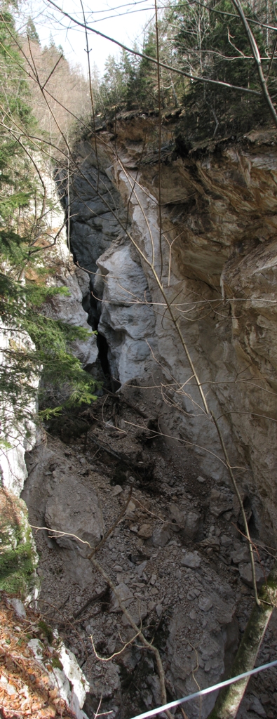
COLLAPSED SECTION OF MLINARICA CLIFFS
Collapsed section is safely reachable, but trail ends there! If you decided to visit this part of gorge too, be careful at the end! This trail could be rated with three stars for terrain.
An old trail led from road (waypoint PARK2) to farms at the other side of Mlinarica gorge, at the slopes of Kukla mountain. There has been a footbridge where trail crosses the narrow gorge. Farms at slopes of Kukla have been disused long time ago, the trail become less important, but still used by mountaineers, foresters, hunters and occasional tourist. It is not so any more! A large section of the overhanging cliffs gave way to gravity and collapsed into the Mlinarica gorge. Many hundreds cubic of rocks, earth, trees and other debris filled the gorge. Since the gorge is very deep and narrow at the place of collapse, main part of material has not reached the bottom - it has wedged halfway down. Now there is a narrow water tunnel underneath this fill and wider gorge above.
Since the collapsed section is exactly where the old footbridge used to be, it is easily reachable. Trail is still in a perfect condition all the way to the gorge. It ends where footbridge used to cross gorge. Some remains of the footbridge are still there, one steel wire rope still linking both sides of the gorge...
TRAIL TO COLLAPSED SECTION
You can start from Earthcache coordinates and reach waypoint COLAPS in less than half an hour on foot:
- Instead of crossing the Soca river, follow marked trail ascending to Kugyjev spomenik;
- Find the start of an old trail (waypoint START) which starts near the small wooden bridge;
- Follow trail uphill, at branching of the path choose right trail;
- Follow the old trail to waypoint SLOPE and further to waypoint COLAPS;
Even thou the trail is in a good condition, be careful when you come close to waypoint COLAPS. DO NOT try to lean over the edge of the collapsed slope! Cliffs are unstable, stop some steps before the old footbridge.
As an alternative, you can also drive to waypoint PARK2, which is very close to starting point of the old trail (waypoint START) and start your walk from there.
Note: You use trails at your own risk. Use only trails you are fit to. Be safe and enjoy!
References: A part of the text is taken from a book "Slovenija na dlani - Soca", Mladinska knjiga Zalozba, Ljubljana, 2009. Foto: vane_si;
|
... |
|
View from the observation platform /
Pogled z razgledne ploscadi |
... |
Collapse of the section at the waypoin COLAPS /
Porusitev zgornjega dela pri tocki COLAPS |
Slovensko besedilo
Obiscite naso spletno stran Geološki zakladi / EarthCaches
za seznam vseh nasih Geoloških zakladov in mnogo dodatnih podatkov.
(SI) KORITA MLINARICE
Korita Mlinarice se nahajajo ob cudoviti dolini Trente, ki objema zgornji del reke Soce. Odmaknjena visokogorska krnica Mlinarica lezi med Prisojnikom in Razorjem. S svojimi snezisci napaja hudourni potok Mlinarico, ki se vklenjen med skalovje Kukle skoraj neopazno izliva v Soco. Potok je izdolbel kilometer dolgo in sto metrov globoko sotesko, ki se pred sotocjem s Soco zozi v edinstvena korita. Najozji deli so siroki le okoli enega metra, na vec mestih so zagozdene skale, ki tvorijo naravne mostove. Potok Mlinarica ima precejsen padec, kar 300 metrov v 700 metrih dolzine! V notranjem, brez posebne opreme neprehodnem delu korit, je vec slapov, skocnikov in tolmunov.
Tik pred izlivom Mlinarice v Soco je enostavno dostopen zakljucek korit, kjer je zgrajena tudi opazovalna ploscad. Tam lahko vsaj zaslutimo, kaj se nahaja za ovinki ozke soteske. Tam so vidne tudi nekatere znacilne kraske oblike, ki jih je v skalo vrezala voda.
ZGODOVINA IN GEOLOGIJA
V zadnjih nekaj sto tisoc letih se je izmenjalo vec ledenih dob z vmesnimi toplejšimi obdobji. Zadnja ledena doba se je koncala pred 10.000 leti. V obdobju vsake poledenitve se je mocno povecalo mehansko preperevanje kamnin. Ledeniki so mocno preoblikovali zemeljsko povrsje, kar velja tudi za doline, ki so jih zapolnjevali.
Pred poledenitvijo dolina reke Soce v primerjavi z okoliskimi gorami ni bila tako globoka. Tudi dolina je bila znatno bolj odsekano oblikovana – z znacilnim precnim prerezom v obliki crke V, ki ga je ustvarila vodne erozije reke. Med vsako poledenitvijo je ledenik poglobil dolino Soce mnogo bolj kot dolino pritoka Mlinarica. Po umiku ledenika so vode Mlinarice pocasi, a neizbezno vrezovale ozko sotesko, ki se je po koncu vaske poledenitve prav tako poglobila.
slika 1:
Mlinarica in okolica. Izrez iz planinske karte Julijske Alpe, Sidarta, 2009
Pobocja Kukle, Golicice, Planje in Razorja tvorijo juzni del prispevnega obmocja Mlinarice, Prisojnikova pa severni del. Iz izseka Geoloske karte je razvidno, da Prisojnik v glavnem sestavlja dolomit, medtem ko so Kukla, Golicica, Planja in Razor na nasprotni strani iz apnenca. Ker je apnenec v vodi in sibkih raztopinah kislin precej bolj topen kot dolomit, je Mlinarica izdolbla sotesko na robu dolomita – v apnencu.
slika 2:
Zgornji del doline Soce z Mlinarico in okolico. Izrez iz Geoloske karte Slovenije, Geoloski zavod Slovenije, 2009
Sestava kamnin Mlinarice z okolico:
84: Masiven debelozrnat dolomit in apnenec; zgornji trias – cordevol (ca. 220 milijonov let);
83: Menjavanje glinavca in pescenjaka, v vrhnjem delu ploscat apnenec – amfiklinse plasti; zgornji trias – karnij (ca. 220 milijonov let);
81: Ploscat apnenec in dolomit z rozencem, laporovec, laporasti apnenec – Tamarska formacija; zgornji trias – karnij (ca. 220 milijonov let);
76: Debeloplastni dachsteinski apnenec s prehodi v dolomit; zgornji trias – norij, retij (ca. 210 milijonov let);
75: Grebenski apnenec s koralami; zgornji trias –retij (ca. 200 milijonov let);
14: Til, morena; kvartat – pleistocen;
GEOLOŠKI ZAKLAD IN DOSTOP
1. OBVEZEN OGLED
OPAZOVALNA PLOSCAD...
... je izbrana za koordinate Geološkega zaklada. Parkirajte svoje vozilo na tocki (waypoint) PARK1. Sledite smerokazom po kratki poti cez Soco. Geološki zaklad boste dosegli v nekaj minutah.
Ze tam so sile, ki oblikujejo zemeljsko povrsje pokazale svojo moc. Prvotni leseni mosticek je bil zgrajen kakih 30m dlje od danasnje ploscadi v soteski. V letu 1999 so hudourne vode mosticek povsem unicile. Na mestu starega, je bil zgrajen nov mostic. A ne za dolgo. Ze pomladi 2005 ga je povsem unicil skalni podor, ki je zgrmel s stene soteske. Dve leti kasneje je bila na varnejsem mestu, tik ob zakljucku soteske, zgrajena sedanja razgledna ploscad.
Ploscad je dostopna celo leto, razen morda v visokem snegu. Vstopnine ni.
2. NEOBVEZEN, DODATEN OGLED
PORUSENI DEL STEN SOTESKE...
... je varno dostopen, vendar se pot nenadoma konča! Ce ste se odlocili obiskati tudi ta del soteske, bodite na koncu zelo previdni!
Stara pot je od ceste na Vrsic (tocka PARK2) vodila h kmetijam na pobocjih Kukle, onstran Mlinarice. Pot je sotesko preckala s kratko brvjo. Kmetije pod Kuklo so ze dalj casa opuscene, zato je pot postala precej manj pomembna. Se vedno so jo uporabljali planinci, gozdarji, lovci in obcasno kak turist. Zdaj temu ni vec tako! Nedavno je pot presekal velik skalni podor! Daljsi del previsnih sten soteske je koncno popustil teznosti in stotine kubicnih metrov skal, zemlje, dreves in ostalega materiala je zapolnilo sotesko. Ker pa je soteska na tem delu zelo globoka in ozka, se je vecina materiala zagozdila preden je dosegla dno. Zdaj je pod nasutjem ozek vodni tunel, nad njim pa sirsa soteska.
Poruseni del soteske je ravno na obmocju bivse brvi, zato je enostavno dostopen po stari poti. Cez pot so na nekaj mestih vrzene veje, da odvrnejo nepoucene, vendar pot nikjer ni oznacena kot zaprta. Pot je se vedno v odlicnem stanju vse do soteske. Konca se na mestu stare brvi, od katere je se vidnih nekaj ostankov. Ena jeklenica se vedno povezuje oba bregova soteske...
POT DO PORUSENEGA PREDELA
... lahko pricnete pri razgledni ploscadi in tocko COLAPS (waypoint COLAPS) dosezete prej kot v pol ure hoje:
- Namesto da bi preckali Soco, sledite oznaceni poti navzgor, do Kugyjevega spomenika;
- Poiscite zacetek stare poti na tocki START (waypoint START), pri malem lesenem mosticu;
- Sledite poti navzgor in ob razcepu izberite desno smer;
- Sledite poti do tocke SLOPE (waypoint SLOPE) in naprej do soteske (waypoint COLAPS);
Ceprav je pot v dobrem stanju, bodite previdni, ko se priblizate soteski (waypoint COLAPS). NE POSKUSAJTE se nagibati preko roba porusene stene soteske! Pobocja so se vedno nestabilna, zato se ustavite nekaj korakov pred koncem poti!
Druga moznost za zacetek poti k soteski je s tocke PARK2, do kamor se lahko pripeljete z avtom. Nahaja se blizu zacetka stare poti (tocka START).
Opomba: Poti uporabljate na lastno odgovornost! Hodite le po poteh za katere ste ustrezno pripravljeni! Zelimo vam varno pot in veliko uzitkov!
Del besedila je povzet iz knjige "Slovenija na dlani - Soca", MKZ,Ljubljana, 2009. Foto: vane_si;
|
... |
|
View from the observation platform /
Pogled z razgledne ploscadi |
... |
Collapse of the section at the waypoin COLAPS /
Porusitev zgornjega dela pri tocki COLAPS |
tocke poti in dnevniki / waypoints and logs