Un grand grand MERCI à " B ", elle comprendra pourquoi ;-))))
Culminant à près de 400m d'altitude, les Monts d'Arrée n'ont rien à envier aux paysages d'Irlande ou d'Ecosse. On y retrouve tous les éléments constituant la magie et le mystère des légendes bretonnes : les crêtes rocheuses, les landes couvertes de bruyères et d'ajoncs qui changent de couleur en fonction des saisons, les ruisseaux, les lacs et les bois. Que ce soit sur le chemin des crêtes ou le long du Yeun Elez, on n'y croise guère que troupeaux isolés, marcheurs ou cavaliers.
Rising to nearly 400m above sea level, the Arrée mountains have every bit as much to offer as the landscapes of Ireland or Scotland. They contain all the elements which constitute the magic and mystery of Breton legends: rocky ridges, moorland covered in heather and gorse - that changes colour with the seasons - streams, lakes and woods. Whether on the crest trail or along the Yeun Elez, there are only isolated herds, walkers or riders.

Rappel :
Sur les "earthcaches", il n'y a ni boîte, ni logbook. Il vous suffit de vous rendre sur place et de répondre aux questions du propriétaire de celle-ci. Vous lui faites parvenir vos réponses en le contactant par mail dans son profil sur Geocaching.com, en cliquant sur "send message" .
Questions pour valider : "Noce de pierres"
1: rendez-vous au point de la cache et dites-nous quelle est la hauteur approximative hors sol du mehnir que vous avez devant vous à ce point exact.
2: rendez-vous au point du panneau informatif sur "la noce de pierres" ( cf tableau de waypoints ) et répondez à la question suivante:
Quelle est la longueur maximale des diamètres externes et des diamètres internes de la couronne ovalaire?
Vous pouvez vous loger sans attendre notre confirmation,
mais vous devez nous envoyer les réponses par mail en même temps: EQUIPE PLONGE29
S'il y a des problèmes avec vos réponses nous vous en ferons part.
Les logs enregistrés sans réponses seront supprimés.
(une photo de vous ou de votre GPS sur place sera la bienvenue, mais n'est pas obligatoire).
Reminder:
On 'Earthcaches', there is neither box nor logbook. Just go there and answer the owner's questions. Send your answers via email by contacting him on his profile on Geocaching.com, click on 'send message'
Questions to validate: 'Noce de pierres'
1/ Go to the cache position and tell us what is the approximate height above ground of the menhir you have in front of you at this exact point.
2/ Go to the point of the informative panel of "the wedding of stones" (see table of waypoints) and answer the following question:
What is the maximum length of outer diametres and inner diametres of the oval ring?
You can log the cache without our confirmation, but you should
send us answers at the same time by e-mail: EQUIPE PLONGE29
If there is anything wrong with your answers we will let you know.
Logs without sending answers will be deleted.
(a picture of yourself or your GPS on site would be welcome but is not mandatory).
L'alignement de " la noce de pierres " ou encore en breton "An Eured Veign " se situe au cœur des Monts d'Arrée, en plein Massif Armoricain.
L'expression Arrée qui s'écrivait par le passé " Arhès" signifierait en vieux "celtique " monts de la séparation", en raison de l'aspect de barrière géologique que présente cette ligne de crêtes.
Le Massif Armoricain , bien que de faible altitude ( 385 m ) est classé parmi les massifs montagneux, tant pour la nature de ses sols que pour ses paysages. Il provient du plissement hercynien. Cette phase hercynienne, qui a débuté il y a 330 millions d'années, est à l'origine des granites qui constituèrent l'ossature d'un montagne puissante.
Le granite est un amalgame de cristaux de quartz, de feldspath et de mica.
The alignment of 'the stones wedding' or, in Breton 'An Euredit Veign' is located in the heart of the Arrée mountains, right in the middle of the Armorican Massif.
The expression 'Arrée', which was written 'Arhès' in the past, supposedly means 'mountains of separation' in old 'Celtic' due to the geological barrier look of this ridge line.
The Armorican Massif, although of low altitude (385 m) is ranked among the mountain massifs, both for the nature of its soil and for its scenery. It comes from the Hercynian folding. The Hercynian phase, which began 330 million years ago, is at the origin of granites that formed the backbone of a powerful mountain.
Granite is a mixture of quartz crystals, feldspar and mica.
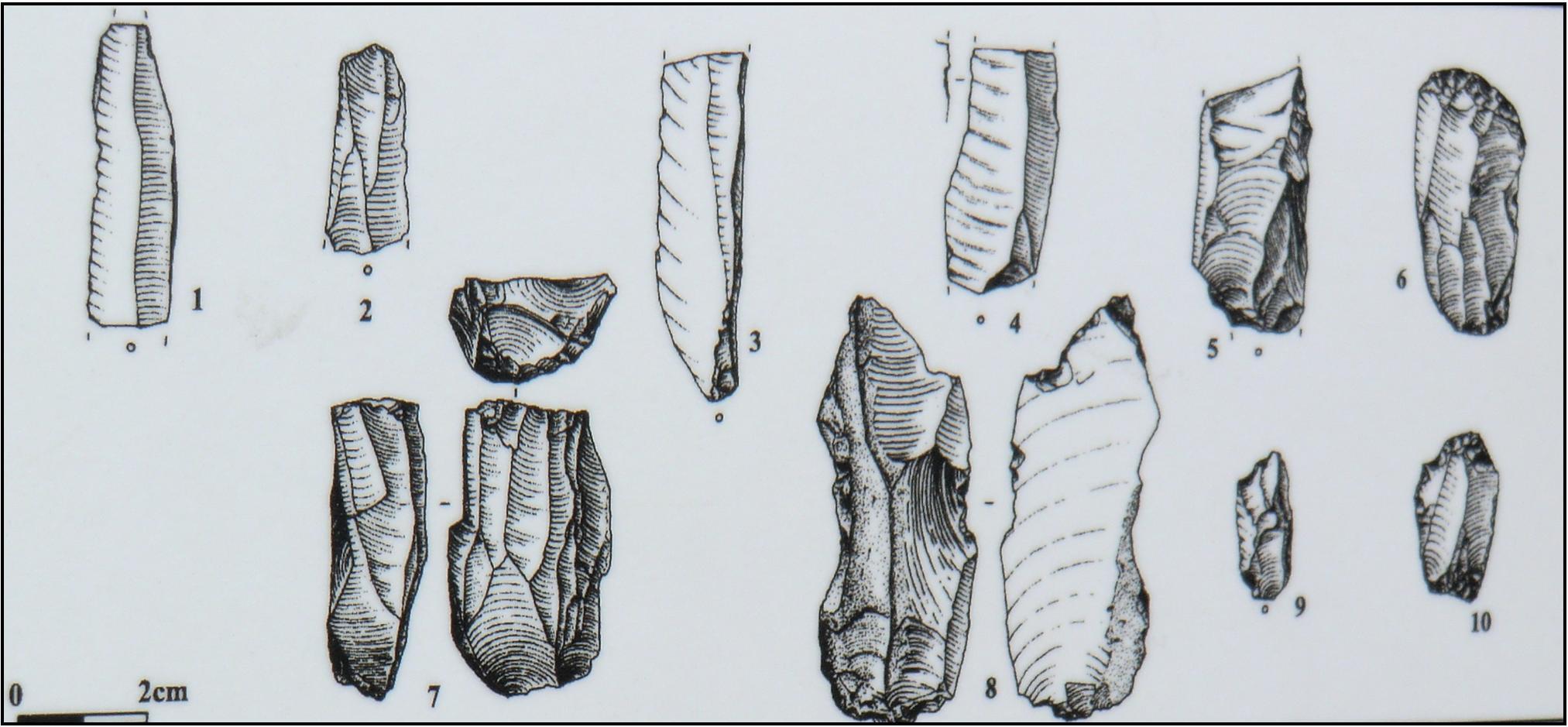
Cet alignement date du néolithique, époque à la frontière entre la préhistoire et histoire ( entre -8000 et -2000 avant JC ), période où les premiers hommes se sédentarisent et inventent l'agriculture, l'élevage, la céramique et certains outils.
Les fouilles entreprises ici laissent penser qu'à un moment donné, l'endroit a été un lieu de vie au néolithique. En effet, le décompte du matériel fait apparaître une chaîne opératoire complète, du nucléus à l'esquille en passant par les éclats, les lames et lamelles.
This alignment dates from the Neolithic, an era between prehistory and history (between -8000 and -2000 BC), when early humans became sedentary and invented agriculture, livestock, ceramics and some tools.
Excavations here suggest that at some point, the place was a place of life in the Neolithic. Indeed, the detailed account of the material shows a complete operational chain, from nucleus to splinter, to slivers and bigger or smaller strips.
Dominant la vallée du Yeun Ellez, cet alignement mégalithique de 300m de long est constitué de 88 mehnirs de taille modeste.
Le plus grand mesure 1,80m et est orienté Ouest /Est . La hauteur de ces blocs est croissante quand on se dirige vers l'Est.
En son centre, on peut retrouver grâce à une différence de végétation, une petite enceinte fossoyée sub-circulaire.
On qualifie de mégalithe, tout monument funéraire constitué de blocs rocheux bruts ou des grandes pierres plantées en lignes, en cercle, isolément ou en groupe.
Ces blocs sont constitués de quartzite ( roche siliceuse massive constituée de cristaux de quartz soudés entre eux ) et de quartz.
Dominating the Ellez Yeun valley, this megalithic alignment of 300m long is composed of 88 standing stones of modest size.
The largest one is 1.80m and is oriented west /east. The height of these blocks goes increasing when you head east.
At its centre, a small sub-circular ditched enclosure can be found thanks to a difference of vegetation.
Anyfunerary monument made of rough boulders or large stones planted in rows, in a circle, separately or in groups is called a megalith.
These blocks are made of quartzite (a massive siliceous rock mass made of quartz crystals fused together) and quartz.
Une légende existe sur cet alignement et raconte qu'une noce paysanne, possédée par le démon de la danse, ait refusé de laisser le passage au recteur de Braspart qui allait porter l'extrême onction à l'un de ses paroissiens mourant.
L'homme d'église et l'enfant de chœur qui l'accompagnait ont dû marcher à travers les landes et broussailles pour accomplir leur mission.
Quant aux noceurs, ils ont été punis et à la dernière note de la dernière danse, ils furent changés en pierres, pierres qui constituent l'alignement, d'où " la noce de pierres ".
sources ( wikipédia et Parc Régional d'Armorique )
There is a legend about this alignment: it tells that possessed by the demon of dance, guests at a peasant wedding refused passage to the priest of Braspart who was bringing Extreme Unction to one of his dying parishioners.
The clergyman and the choir boy who went with him had to walk across the moors and brush to accomplish their mission.
As for the wedding guests, they were punished and at the last note of the last dance, they were changed into stones - the stones that make up the alignment, hence "the wedding of stones".
sources(wikipedia and Brittany Regional Park)
Très bon géocaching