Chimaera - The Ethernal Flames of Yanartas
This Earthcache will lead you to an unique geological feature in Lycia / Turkey:
a real "burning mountain" - the ethernal flames of Yanartas!
A myth tells that the flames are still the breath of nearby buried Chimaera, a monster with the head of a lion, the body of a goat and the tail of a snake, snorting out the breath of bright fire, which has been killed near this location by an ancient hero called Bellerophon or Bellerophontes some thousand years ago...

Geology of the Taurus Mountains
Mountain range in southern Turkey, running parallel to the Mediterranean Sea. It is defined to two main parts, the western called Bati, the eastern Orta.
 The Bati begins in the region corresponding to ancient Lycia, west of Antalya and melts into the Orta, in the section known as Geyik (about 150 km east of Antalya). The Orta continues eastwards to the Euphrates River, from where the Güneydogu Mountains are defined to begin.
The Demirkazik Mountain in the east, is the highest mountain at 3,756 metres, neighboured by two more mountain tops over 3,700 metres, in a region known as Aladaglar. The highest mountain in the western parts is the Kislar Sevrisi at 3,083 metres.
The mountains are of limestone, much of it white limestone. The mountains are between heavily and scattered forested, trees being pine, cedar, oak and juniper. The tree limit is about 2,000 to 2,500 metres. The mountains have several lakes, although many of these are seasonal or dried out.
The mountains reach all the way out to the ocean, leaving only a narrow strip of flatland in regions.
The western Taurus served in ancient times as a natural fortress for Lycia, allowing the development of high-culture and rich trading cities.
The region is fairly thinly populated, but has excellent road infrastructure. The main cities are Antalya (600,000), Isparta (150,000), Eregli (90,000),Fethiye (60,000) and Silifke (60,000, all figures 2004 estimates).
The main activities of the region are agriculture, small-scale industries and tourism. Mineral deposits include silver, copper, lignite, zinc, iron and arsenic.
-----------------------------
Türkiye'nin güneyinde, Akdeniz'e paralel uzanan sıradağlar. Batısı Batı, doğusu Orta olmak üzere iki ana kısma ayrılmıştır. Batı, Antalya'nın batısında, antik Likya'ya karşılık gelen bölgede başlar ve Geyik olarak bilinen kesimde (Antalya'nın yaklaşık 150 km doğusunda) Orta'ya doğru erir. Orta, doğuya doğru, Güneydoğu Dağları'nın başladığı tanımlanan Fırat Nehri'ne doğru devam eder. Doğudaki Demirkazık Dağı, Aladağlar olarak bilinen bir bölgede, 3,700 metreyi aşan iki dağ zirvesi ile komşu, 3.756 metre ile en yüksek dağıdır. Batı kesimlerinin en yüksek dağı 3.083 metre ile Kışlar Sevrisi'dir. Dağlar kireçtaşından, çoğu beyaz kireçtaşından. Dağlar yoğun ve dağınık ormanlar arasındadır, ağaçlar çam, sedir, meşe ve ardıçtır. Ağaç sınırı yaklaşık 2.000 ila 2.500 metredir. Dağlarda birkaç göl vardır, ancak bunların çoğu mevsimsel veya kurudur. Dağlar okyanusa kadar uzanır ve bölgelerde yalnızca dar bir düzlük şeridi bırakır. Batı Toroslar antik çağda Likya için doğal bir kale işlevi görmüş, yüksek kültürlü ve zengin ticaret şehirlerinin gelişmesine olanak sağlamıştır. Bölge oldukça az nüfusludur, ancak mükemmel bir yol altyapısına sahiptir. Başlıca şehirler Antalya (600.000), Isparta (150.000), Ereğli (90.000), Fethiye (60.000) ve Silifke'dir (60.000, tüm rakamlar 2004 tahminleridir). Bölgenin ana faaliyetleri tarım, küçük ölçekli sanayi ve turizmdir. Maden yatakları arasında gümüş, bakır, linyit, çinko, demir ve arsenik bulunur.
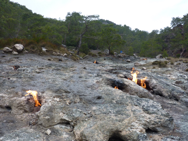
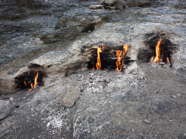
The facts about Yanartas
Yanartas, proposed as the ancient Mount Chimaera, is the name of a geographical feature near Olympos valley and national park in Antalya Province in southwestern Turkey, in the Taurus Mountains, at a distance of about eighty kilometers to the southwest from the city of Antalya, near the town of Çirali.
It is characterized by a permanent fire caused by emissions of a gas mixture and the area is located on a track popular with hikers and trekkers on the Lycian Way.
Called in Turkish Yanartas (flaming rock), the spot consists of various vents in the ground formed of limestone, grouped in two patches on the hillside above the ruins of the Temple of Hephaistos, about three kilometers north of the village of Çirali, near ancient Olympos, in Lycia. The vents emit gas which is thought to be of metamorphic origin. In ancient times sailors could navigate by the flames, but today they are more often used to brew tea or grill sausages. Because of their reduced size the flames are of little use for navigation nowadays.
The analysis of the gas mixture emitted by the vents shows a high rate of methane and also high rates of oxygen and nitrogen. The probability that the gases have an organic source is, looking at the carbon isotope values, about 20 to 90 %, the probability of having a vulcanic source is about 25 %. The feature is not comparible with a coal fire like the one in Centralia, Pennsylvania (U.S.). Nevertheless it's not completely researched until now.
--------------------------
Antik Yanartaş Dağı olarak önerilen Yanartaş, Türkiye'nin güneybatısında, Antalya ilinde, Toros Dağları'nda, Antalya ilinin yaklaşık seksen kilometre güneybatısında, Olympos vadisi ve milli parkın yakınında bulunan coğrafi bir özelliğin adıdır. Çıralı ilçesine yakın. Bir gaz karışımının emisyonundan kaynaklanan kalıcı bir yangın ile karakterizedir ve alan, Likya Yolu üzerinde yürüyüşçüler ve yürüyüşçüler arasında popüler olan bir parkur üzerinde yer almaktadır. Türkçe'de Yanartaş (yanan kaya) olarak adlandırılan nokta, antik kentin yakınlarındaki Çiralı köyünün yaklaşık üç kilometre kuzeyinde, Hephaistos Tapınağı kalıntılarının üzerindeki yamaçta iki parça halinde gruplandırılmış, kireçtaşından oluşan zeminde çeşitli havalandırmalardan oluşuyor. Olympos, Likya'da. Menfezler, metamorfik kökenli olduğu düşünülen gaz yayar. Eski zamanlarda denizciler alevlerin yanında gezinebiliyorlardı, ancak bugün daha çok çay demlemek veya sosis ızgara yapmak için kullanılıyorlar. Alevler küçültülmüş boyutları nedeniyle günümüzde navigasyon için pek kullanılmamaktadır. Havalandırmalardan yayılan gaz karışımının analizi, yüksek oranda metan ve ayrıca yüksek oranlarda oksijen ve azot gösterir. Gazların organik bir kaynağa sahip olma olasılığı, karbon izotop değerlerine bakıldığında, yaklaşık %20 ila 90, vulkanik bir kaynağa sahip olma olasılığı ise yaklaşık %25'tir. Bu özellik, Centralia, Pennsylvania'daki (ABD) olduğu gibi bir kömür ateşiyle karşılaştırılamaz. Bununla birlikte, şimdiye kadar tam olarak araştırılmamıştır.
The Myth of the Chimaera
Bellerophon's brave journey began in the familiar way, with an exile: he had murdered either his brother, whose name is usually given as Deliades, or killed a shadowy "enemy", a "Belleros", and in expiation of his crime arrived as a suppliant to Proetus, king of Tyrins. Proetus, by virtue of his kingship, cleansed Bellerophon of his crime. The wife of the king took a fancy to him, but when he rejected her, she accused Bellerophon of attempting to ravish her. Proetus dared not satisfy his anger by killing a guest, so he sent Bellerophon to King Iobates, his father-in-law, in the plain of the River Xanthus in Lycia, bearing a sealed message in a folded tablet: "Pray remove the bearer from this world: he attempted to violate my wife, your daughter." On reading the tablet's message Iobates, too feared the wrath of the Erinyes if he murdered a guest, sent Bellerophon on a mission that seemed impossible: to kill the fire-breathing monster Chimaera, living in neighboring Caria. The Chimaera was a fire-breathing monster whose make-up comprised the body of a goat, the head of a lion and the tail being a serpent. This monster had terrorized the nearby countryside.
The Lycian seer Poleyeidos told Bellerophon he would have need of the winged horse Pegasus for this mission. To obtain the services of the untamed winged horse, Bellerophon went to the temple of Athene. Some accounts say that Athena brought Pegasus already tamed and bridled, or that Poseidon, the horse-tamer, secretly the father of Bellerophon, brought Pegasus. Bellerophon mounted his steed and flew off to where the Chimera was said to dwell.
When he arrived in Lycia, the Chimaera was truly ferocious, and he could not harm the monster even while riding on Pegasus. He felt the heat of the breath the Chimaera expelled, and was struck with an idea. He got a large block of lead and mounted it on his spear. Then he flew head-on towards the Chimaera, holding out the spear as far as he could. Before he broke off his attack, he managed to lodge the block of lead inside the Chimaera's throat. The beast's fire-breath melted the lead, and blocked its air passage. The Chimaera suffocated, and Bellerophon returned victorious to King Iobates.
Access to the location:
There is a public parking place near N 36° 25.767 E 030° 27.886. If you choose this way to the location you have to pay a small entrance fee. From all other sides in principle public access is free.
Your task to log this Earthcache:
Visit the place and send me a message (not mail) (in English or German, please!) via my account with answers to the following questions:
1.) Give me a short description (with your own words), how the limestone cavities have been formed by the flames!
2.) How many burning flames did you count at the location?
3.) Tell me the percentage of methane gas in the gas mixture emitted by the vents! (You can find this information at the information table near the entrance)
4.) (optional) If you like, you are warmly invited to add a photo of yourself with your GPS near the header coordinates to your log entry!
Please, dont't wait for an answer with log permission! Just log your visit after you've sent me the answers - I'll only contact you if there's something wrong!
Bu Earthcache'i kaydetme göreviniz: Yeri ziyaret edin ve bana hesabım üzerinden aşağıdaki cevapları içeren bir mesaj (İngilizce veya Almanca, lütfen!) gönderin:
1.) Kireçtaşı boşluklarının alevler tarafından nasıl oluştuğunu (kendi kelimelerinizle) bana kısaca anlatın!
2.) Bulunduğunuz yerde kaç tane yanan alev saydınız?
3.) Menfezlerden yayılan gaz karışımındaki metan gazının yüzdesini söyleyin! (Bu bilgiyi girişin yanındaki bilgi masasında bulabilirsiniz)
4.) (isteğe bağlı) İsterseniz, günlük girişinize başlık koordinatlarının yakınında GPS'inizle kendi fotoğrafınızı eklemeye davetlisiniz!
Lütfen, günlük izniyle bir cevap beklemeyin! Bana cevapları gönderdikten sonra ziyaretinizi kaydedin - sadece bir yanlışlık olursa sizinle iletişime geçeceğim!
It's highly recommended to visit this earthcache in combination with the traditional caches GC2A0JZ & GCM7XP nearby!
Enjoy the location and this unique feature - happy caching!
Silberschakal
 The
most exciting way to learn about the Earth and its processes is to get
into the outdoors and experience it first-hand. Visiting an Earthcache
is a great outdoor activity the whole family can enjoy. An Earthcache
is a special place that people can visit to learn about a unique
geoscience feature or aspect of our Earth. Earthcaches include a set of
educational notes and the details about where to find the location
(latitude and longitude). Visitors to Earthcaches can see how our
planet has been shaped by geological processes, how we manage the
resources and how scientists gather evidence to learn about the Earth.
To find out more click HERE.
The
most exciting way to learn about the Earth and its processes is to get
into the outdoors and experience it first-hand. Visiting an Earthcache
is a great outdoor activity the whole family can enjoy. An Earthcache
is a special place that people can visit to learn about a unique
geoscience feature or aspect of our Earth. Earthcaches include a set of
educational notes and the details about where to find the location
(latitude and longitude). Visitors to Earthcaches can see how our
planet has been shaped by geological processes, how we manage the
resources and how scientists gather evidence to learn about the Earth.
To find out more click HERE.