Sheepeater Cliff EarthCache
-
Difficulty:
-

-
Terrain:
-

Size:  (not chosen)
Please note Use of geocaching.com services is subject to the terms and conditions
in our disclaimer.
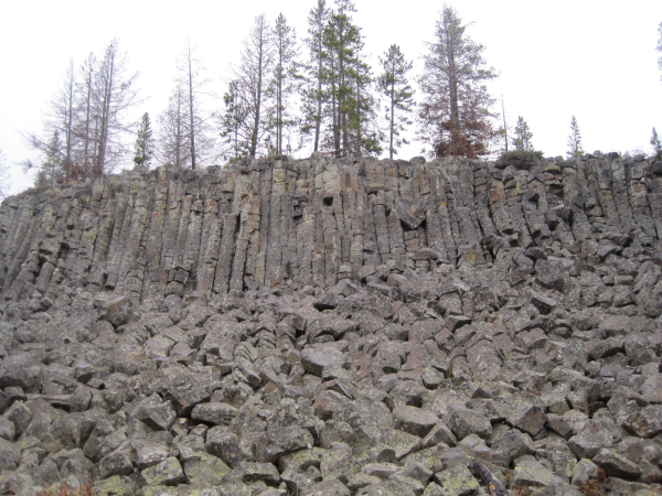
The Sheepeater Cliffs are a series of exposed cliffs
in Yellowstone National Park. The lava was deposited during one of
the periodic basaltic floods in Yellowstone Caldera, and later
exposed by the Gardner River.
During the cooling of a thick lava flow, contractional joints or
fractures form. If a flow cools relatively rapidly, significant
contraction forces build up. While a flow can shrink in the
vertical dimension without fracturing, it cannot easily accommodate
shrinking in the horizontal direction unless cracks form. The
extensive fracture network that develops results in the formation
of columns. Because hexagons fit together efficiently with no
vacant space, this is the most common pattern that develops.
Pentagonal, heptagonal or octagonal joint patterns are also known,
but are less common. Note that the size of the columns depends
loosely on the rate of cooling; very rapid cooling may result in
very small columns, and vice versa. .

Logging requirements:
Send me an email with:
1) The text "GC2KJ01 Sheepeater Cliff" on the first line
2) The number of people in your group.
3) What is Sheepeater Cliffs an example of?
4) What is the shape of the top of each vertical rock pillar?
5) Why do you think they form in that shape?
6) How rapid do you believe this lava flow cooled and why?
7) What do you believe was the biggest contributing factor to the
lava's rapid cooling?
8) Estimate the average height of the cliffs?
9) Estimate the number of columns there is from the coordinates
posted above to the waypoint coordinates posted below.
10) (Optional) Take a photo of your group and gpsr with the cliffs
in the background preferably of a different location then the pic
above
SHEEPEATER CLIFF VIDEO
Additional Hints
(No hints available.)