|
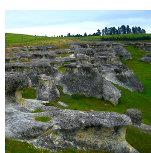
The Elephant Rocks locality features strangely sculpted remnants of Otekaike Limestone. The limestone started out as limey sand on the sea floor around 24 million years ago, during the Oligocene Epoch. Later, the limey sand was buried and gradually turned into sedimentary rock.
In recent geological times, within the last few million years, the limestone was uplifted and exposed. Water and wind have since weathered the limestone into the shapes you will see when visiting this earthcache. If you look closely, you may see some of the original "bedding" (original sea floor) still indicated by lines in the rock.

Movie buffs may recognise this area as the location of Aslan's camp in the recent Chronicles of Narnia movie.
Limestone
Limestone is a sedimentary rock composed largely of the minerals calcite and/or aragonite, which are different crystal forms of calcium carbonate (CaCO3). Limestone makes up about 10% of the total volume of all sedimentary rocks.
Like most other sedimentary rocks, limestones are composed of grains; however, most grains in limestone are skeletal fragments of marine organisms such as coral or foraminifera. Other carbonate grains comprising limestones are ooids, peloids, intraclasts, and extraclasts. Some limestones do not consist of grains at all and are formed completely by the chemical precipitation of calcite or aragonite. i.e. travertine.
The solubility of limestone in water and weak acid solutions leads to karst landscapes. Regions overlying limestone bedrock tend to have fewer visible groundwater sources (ponds and streams), as surface water easily drains downward through joints in the limestone. While draining, water and organic acid from the soil slowly (over thousands or millions of years) enlarges these cracks; dissolving the calcium-carbonate and carrying it away in solution. Most cave systems are through limestone bedrock.
Limestone often contains variable amounts of silica in the form of chert (aka chalcedony, flint, jasper, etc.) or siliceous skeletal fragment (sponge spicules, diatoms, radiolarians), as well as varying amounts of clay, silt and sand sized terrestrial detritus carried in by rivers. The primary source of the calcite in limestone is most commonly marine organisms. These organisms secrete shells made of aragonite or calcite and leave these shells behind after the organism dies.
Calcite can be either dissolved by groundwater or precipitated by groundwater, depending on several factors including the water temperature, pH, and dissolved ion concentrations. Calcite exhibits an unusual characteristic called retrograde solubility in which it becomes less soluble in water as the temperature increases.
Otekaike Limestone
Geologist Dr Maxwell Gage named the Kokoamu Greensand and the overlying Otekaike Limestone in the 1950s, as part of geological research in the North Otago region. Gage's map and report of the district resolved many problems in an area long-studied and debated by geologists and paleontologists.
The underlying Kokoamu Greensand is rich in fossils and has yielded a number of whale and penguin fossils, along with an abundance of microfossils. The Otekaike Limestone, in contrast, is poorly fossiliferous.
In recent times, in an attempt to accurately date the bedding of the Otekaike Limestone, strontium isotope analysis of molluscan (pectinid) macrofossil fragments and mainly benthic foraminifera from the Otekaike Limestone has, together with foraminiferal and nannofossil bio-stratigraphy, provided a chronology for the section and established a correlation with the global time-scale. Strontium isotope ratios of macrofossil and foraminiferal extracts are identical and indicate an age for the section ranging from c. 25.5 Ma at the base to c. 23.7 Ma at the top, placing most of the section within the late Oligocene (Chattian).
This Earthcache
In order to log this earthcache, you will need to visit Elephant Rocks (at the published coordinates) and perform the tasks below. Answers are to be emailed to the cache owner, and NOT included in your online log.
Elephant Rocks are located on private property, but public foot access to view the rocks is permitted by the owners. Please respect that this area is part of a working farm and go quietly if animals are present in the area. No samples whatsoever may be collected from this site.
1. At each of the additional "Rock" waypoints, please describe the size, shape and surface texture of the large rock there. Please note any differences in texture on different sides of the rocks and offer a possible explanation.
2. Take a look around at the large rocks in the area and describe at least one feature (eg colours, layers, etc) you observe that relates to the formation of this limestone on the seafloor.
Please also take a photo near the published coordinates including your GPS and the Elephant Rocks in the background.
You can log this cache straight away after you have emailed your answers to the cache owner, no need to wait for confirmation. Please include the name of this earthcache in the email - you'd be surprised how many people forget. Also, when contacting us with answers, if you want a reply, please include your email address. Any problems with your answers we'll be in touch.
Happy earthcaching!
|