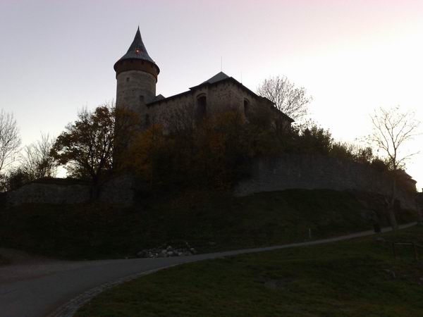
 Díky své siluete
a monumentálnímu postavení v krajine byla osídlena
již v období praveku. Doloženo je osídlení
mladší a pozdní doby bronzové a starší doby
železné. Puvodní kupovitý tvar hory byl narušen
v prubehu staletí težbou kamene a získal
ve stredoveku novou siluetu v podobe kamenného
hradu.
Díky své siluete
a monumentálnímu postavení v krajine byla osídlena
již v období praveku. Doloženo je osídlení
mladší a pozdní doby bronzové a starší doby
železné. Puvodní kupovitý tvar hory byl narušen
v prubehu staletí težbou kamene a získal
ve stredoveku novou siluetu v podobe kamenného
hradu.
Na základe archeologických výzkumu lze ríci, že rozsáhlý
hradní komplex stál na Kunetické hore již v druhé
polovine 14. století. Do širšího povedomí se
Kunetická hora dostala za husitských válek. Za Viléma
z Pernštejna a jeho synu Vojtecha a Jana
dochází v letech 1491 až
1548 k nejvetší prestavbe hradu. Hradní obydlí se
postupne promenilo v nekolika stavebních úpravách, pozdne
gotických a renesancních, v zámecké sídlo. Strategickou
úlohu mela Kunetická hora za tricetileté války. Roku
1645 dobylo hrad švédské vojsko. Vyplenený
a vypálený objekt podléhal rychle zkáze. Urychlila ji
dlouhodobá težba kamene trvající až do pocátku
20. století. Znamenala likvidaci západní a jihozápadní
cásti hradu, která se zrítila do lomu. V roce
1953 prešel objekt do majetku státu. Pro neúdržbu
a následný špatný stav byl v 70. letech hrad
uzavren. Po provedení oprav byl znovu zprístupnen v roce
1993.
A nyní k
samotné cache:
Pro uznání logu
musíte navštívit Kunetickou horu, zodpovedet správne otázky
ze stage 1 a 2, které pošlete pres muj profil a vyfotit se
se svou GPS na stage 3
(dobrovolné).
Stage 1 (N 50° 04.928 E 015°
48.306):
Jaká kupa je Kunetická hora z geologického
pohledu? (Pozn. Cedule má dve strany.)
Stage 2
(N 50°
04.837 E 015° 48.846):
Teleso studny v hlubší cásti zrejme využívá
hlubokou terénní rozsedlinu mezi znelcovým masivem a kterými
okolními vrstvami?
Stage 3
(N 50°
04.776 E 015° 48.810):
Na tomto míste poridte fotografii sebe a GPS prístroje.
V pozadí muže být hrad nebo Pardubice (vyberte si).
Fotografii nahrajte k Vašemu logu. (Tato stage je
dobrovolná.)

 Hill „Kunetická
hora“
Hill „Kunetická
hora“
Kunetická hora is a characteristic feature of the eastern
part of Czech Elbe, created by tertiary activities of the
earth. It was formed
about 30 million years ago and has never been a
volcano. The lava
stiffened shallowly below the surface and its present form was
revealed by erosion of cretaceous beds.
Because of its shape and position in the monumental
landscape, it has been inhabited since prehistoric time. Population
is documented from younger and late Bronze Age and older Iron
Age. The
hill’s original cumulous shape had been corrupted by stone
quarrying over the centuries and got a new silhouette in a stone
castle form in the Middle Ages.
Based on archaeological
excavations, we can say the vast castle complex “Kunetická
hora” stood on in the second half of the 14th century.
The object was coming under a rapid destruction in the
17th century. It was speeded up by the long-term
quarrying lasting until the early 20th century. It meant
a destruction of the western and south-western parts of the castle
which fell into the quarry.
And now
for the cache itself:
For the
log acceptation, you need to visit the hill „Kunetická
hora“, correctly answer questions from stages 1 and 2 and
send them by my profile and accomplish the task in
stage 3
(optional).
Stage 1
(N 50°
04.928 E 015° 48.306):
What is a
cluster of Kunetická hora from a geological point of
view? (Note: The poster has two sides.)
Stage 2
(N 50°
04.837 E 015° 48.846):
Body of
the well in its deeper part uses a deep field fissure between the
phonolite massif and which surrounding layers?
Stage 3
(N 50°
04.776 E 015° 48.810):
At this
point, take a photo of yourself and your GPS device. The
castle or Pardubice town can be in the background (take your
choice). Upload the photo to your log. (This stage is
optional.)
