Den senaste Istiden
För ungefär 70 000 år sedan började inlandsisen breda ut sig
över Sverige och Skandinavien. Isen hade sin maximala utbredning
för ca 22 000 år sedan då den nådde delar av Jylland, norra
Tyskland och norra Polen.
När klimatet så småningom blev varmare började isen smälta och
för ungefär 16 000 år sedan låg iskanten vid Skånes sydkust. Isen
smälte sedan undan för undan men tillbakagången var ryckig och
varma perioder med kraftig avsmältning växlade med kalla perioder
och långsammare tillbakagång av isen.
Rullstensåsarna
När inlandsisen smälte bildades stora mängder vatten som forsade
fram på, i och under isen. Dessa jättelika isälvar följde ofta
dalgångarna i berggrunden. Det strömmande vattnet i isälvarna tog
med sig stora mängder löst material, stenar, grus, sand m.m. när
det forsade fram under isen. När vattnet närmade sig iskanten
minskade strömhastigheten och vattnets transportförmåga och
materialet började sjunka mot botten.
Först sjönk de större stenarna och blocken medan det finare
gruset följde med vattnet längre från tunnelöppningen. På så vis
skapades rullstensåsar som alltså har grova stenar djupt ner och
fint grus högre upp i åsen. Under färden då block och stenar
forsade fram i isälvarna nöttes de av strömmarna och rundades till
rullstenar, därav namnet rullstensås.
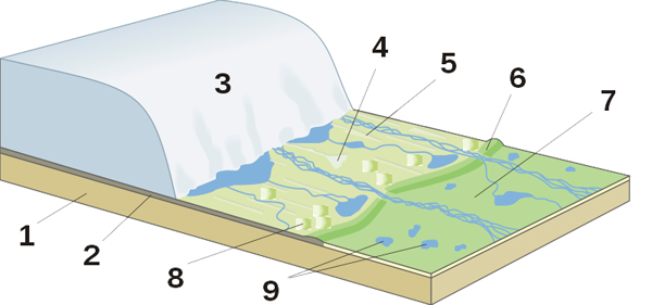
1)
Berggrunden, 2) Moränlager, 3) Glaciär som smälter, 4) Rullstensås,
5) Drumliner, 6) Ändmorän,
7) Slättmark efter smältvattensjö, 8) Kamekullar, 9) Dödisgrop.
För att logga:
- Försök uppskatta hur hög åsen är från koordinaten ner till
våtmarken.
- Använd en karta för att följa åsen söderut i kommunen.
Maila cacheägaren något utav åsens namn på väg söderut.
- Ta gärna ett foto på omgivningen och din GPS vid
cachekoordinaten.(Friviligt)
Du behöver inte vänta på mailsvar om du skickar med bild i din
logg, för att få logga men, loggar som inte har försökt svara på
frågorna kommer att raderas.
English
The esker stretches itself along Lyckebyån throughout the
municipality. On this place, an old road is up on the ridge that is
indicated already on maps from 1700 century, but is probably older
than so. The ridge changes names gradually that it runs through the
municipality.
The last glacial
period
For approximately 70 000 years since began the ice sheet broad
out itself over Sweden and Scandinavia. The ice had its maximum
spread for approximately 22 000 years since then it reached parts
of Jylland, northern Germany and the northern Poland.
When the climate gradually became warmer the ice begun to melt
and for approximately 16 000 years since the low ice edge wide
Skåne's south coast. The ice melted afterwards away for away but
the decline was jerky and hot periods with considerable ice melting
alternated with cold periods and slower decline of the ice.
The Eskers
When the inland area ice melted refined big quantities waters
that gushed forward on, in and during the ice. These enormous ice
rivers followed the often long valleys in the bedrock. The
swiftly-flowing water in the ice rivers took with itself big
quantities loose materials, stones, grits, concrete etc. when it
gushed forward during the ice. When the water approached the ice
edge the slimmed-down power speed and the water's transport ability
and the material begun to fall against the bottom.
First fell the bigger stones and the blocks while the more
delicate grit followed with the water longer from the tunnel
opening. On so sensible created eskers that therefore have coarse
stones deep down and delicate grits higher up in the ridge. During
the journey then blocks and stones gushed forward in the ice rivers
was abraded the of the powers and was rounded to rounded stones. In
Swedish "rolling stones". The name Esker is derived from the Irish
word eiscir (Old Irish: escir), which means: "a ridge or elevation,
especially one separating two plains or depressed surfaces".
1)
Bedrock, 2) Tilllayer, 3) Melting glacier, 4) Esker, 5) Drumlins,
6) Terminal moraine,
7) Flat ground after melt water lake, 8) Kamehills, 9)
Kettlers.
To log this:
- Try to estimate how high the ridge is from the coordinates down
to the wetland.
- Use a map to follow the esker south through the
municipality.
Mail cache owner some of the eskers name on its way south.
- Take a photo with the surroundings and your GPS by the cache
coordinates. (Optional)
You don't need to wait on mail answer if you send a photo in
your log, to log but if you try to log without trying to answer the
questions you log will be erased.