Die Brücken des
Weißenbach - Bonus
The Weißenbach Bridges -
Bonus
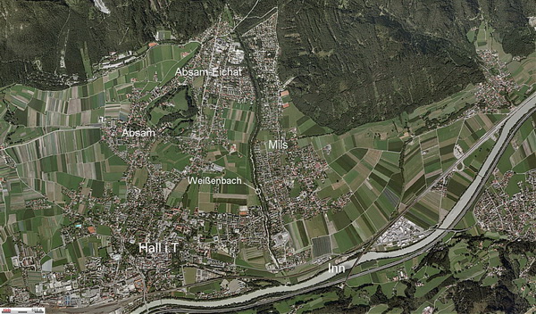
Der Weißenbach entspringt oberhalb der
Herrenhäuser im Halltal und fließt durch das Halltal.
Er bildet die Gemeindegrenze zwischen Hall i.T., Mils und
Absam.
Er ist ca. 8,3km lang - die Quelle liegt auf 1.580m.
Der Bach überwindet einen Höhenunterschied von ca. 1000m bei einem
Gefälle von 8-9%.
Er mündet in der Nähe der Westbahnstrecke in den
Inn.
Das ist der Bonuscache der 7-teiligen Serie "Die
Brücken des Weißenbach - 1 bis 7" am Unterlauf des
Weißenbach.
Die Serie führt von der Mündung des Weißenbach in den Inn bis zum
Eingang des Halltales.
Um die gesamte Serie zu machen benötigst du 3 h reine Gehzeit (2 h
aufwärts; 1 h abwärts).
Wenn du alle Hinweise in den Deckeln der Caches gesammelt hast,
führen dich die so gewonnenen Koordinaten
zu diesem Bonuscache, den du am Rückweg suchen kannst!
Die Koordinaten des Bonus
lauten:
N 47 1X.RST E 11 3V.UTW
The Weißenbach rises above the
Herrenhäuser in the Halltal and flows trough the Halltal.
It marks the borderline between Hall i.T. and the villages of Mils
and Absam.
It is about 8.3km (5.2mi) long - the spring is located at
1.580m.
The brook overcomes an altitude
difference of 1.000m and has a gradient of
8-9%.
It merges near
the Austrian Railways route with the Inn River.
This is the bonuscache of the
series of the 7 Caches "The Weißenbach Bridges - 1 to 7" at the
lower reaches of the Weißenbach.
The series leads from the merging
of the Weißenbach with the Inn river up to the entry of the
Halltal.
It takes about 3 hrs walking time for the whole series (2 hrs up; 1
hr down).
If you have collected all hints in the lids of the caches, the so
estimated coordinates
will lead you to this bonuscache, which you can search on your way
back.
The coordinates of the bonus
are:
N 47 1X.RST E 11 3V.UTW
© Land
Tirol
Cache #9
von: