Geologischer Erlebnispfad in Streitberg
Ein sehr interessanter und abwechslungsreicher Lehrpfad über die geologischen Besonderheiten der Fränkischen Schweiz, gelegen in einer sehr schönen und reizvollen Landschaft.
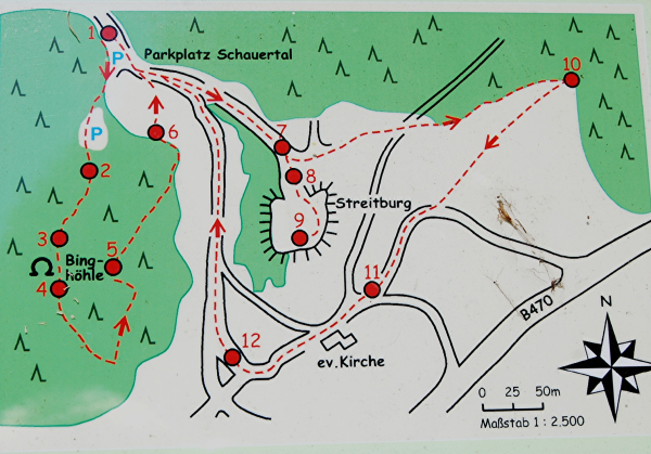
Der Lehrpfad ist ein Rundweg von ca. 3,6 km Länge mit dem Zeichen  Er beginnt am Parkplatz im Schauertal.
Leider fehlen teilweise die Wegzeichen, deshalb ist es empfehlenswert sich entweder an der Binghöhle einen Flyer des Lehrpfades zu holen oder die Karte / Koordinaten mitzunehmen.
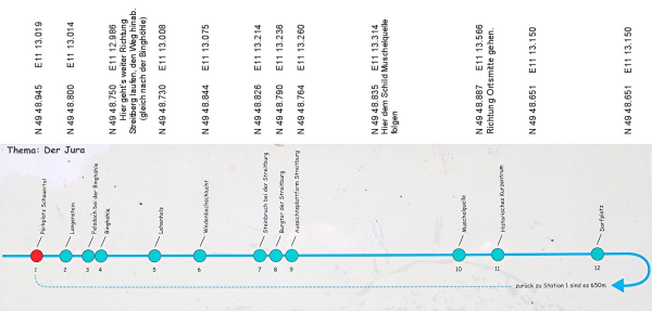
An 12 Stationen werden geologische Besonder- und Gegebenheiten der Weiß-Jura Schichtstufe gezeigt und erklärt.
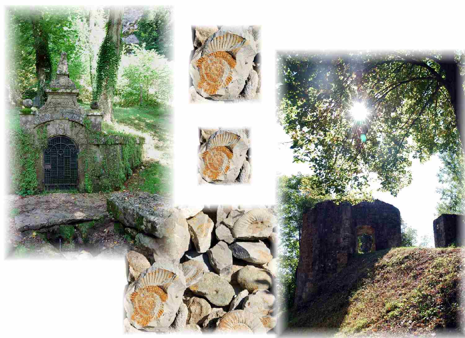
So könnt ihr Quellen, Höhlen Kalktuffterrassen, einen Wasserfall, Versteinerungen, typische Gesteine und noch einiges mehr entdecken.
An den Schautafeln gibt es Informationen über die Erd - und Landschaftsgeschichte und die Geschichte des Kurortes Streitberg, das zu den bekanntesten Orten der Fränkischen Schweiz gehört.
Die Fränkischen Schweiz ist der nördliche Teil der Fränkischen Alb und umfasst tatsächlich eigentlich nur das Einzugsgebiet der Wiesent.
Sie gehört zum süddeutschen Schichtstufenland und ist ein typisches Karstgebiet.
Diese Schichtstufen haben sich schon in der Tertiär- oder Kreidezeit gebildet und lagerten im Laufe von über 40 Millionen Jahren die verschiedenen Schichten des Juragesteins ab. Sie ist ein Mittelgebirge, das fast ausschließlich aus Sedimentgesteinen der Jurazeit besteht.
- Schwarzer Jura oder Lias
Dies ist meist ein dunkles Gestein und die älteste und tiefste Schicht. In ihr ist eine große Anzahl von Fossilien enthalten.
- Brauner Jura oder Dogger
Er hat einen hohen Eisengehalt und deshalb eine bräunliche Färbung. Er enthält auch rostbraunen Sandstein, indem oft die Felsenkeller angelegt sind.
- Weißer Jura oder Malm
Er besteht aus Kalk und Dolomit, hat wenig Verunreinigungen, deshalb die weiße Farbe.Die Felsen der Fränkischen Schweiz bestehen aus Schwammkalk und sind versteinerte Schwamm-Algen-Riffe.

Entstehung dieser Schichtstufen-Landschaft
Bei mehrfachem zusammenhängendem Auftreten von Schichtstufen spricht man von einer Schichtstufen-Landschaft. Jede dieser Schichtstufen kennzeichnen durch das typische Gestein und die darin enthaltenen, ebenso artspezifischen Fossilien ihre eigene Zeitepoche.
Vor ca 140-150 Millionen Jahren war die Fränkische Schweiz ein warmes, flaches und tropisches Meer, durchsetzt von vielen kleinen und großen Schwamm-Algen-Riffen.
Mächtige Gesteinsfolgen wurden am Meeresgrund, wegen der ständigen Absenkung der Erdkruste, abgelagert.
Das Meer zog sich durch die Hebung der europäischen Kontinentalplatte zurück und die Gesteinsschichten wurden schräg gestellt.
Durch das tropische Klima kam es zu einer starken Verwitterung der Gesteine.
Dann stieß in der Zeit der Oberkreide wieder ein Meer in den Bereich der Fränkischen Schweiz vor.
Es erfolgte, durch regionale Hebung, ein erneuter Meeresrückgang sowie eine teilweise Freilegung dieser Juralandschaft.
Dadurch haben wir hier die ganze Schichtenfolge vom Buntsandstein bis hin zur Kreide.
Aufgaben:
- Wo liegt das eigentliche Gebirge " Karst "?
- Welches Klima herrschte im älteren Kalktuff und vor wie viel Jahren gab es ihn?
- Vor dem Eiszeitalter floss der Urmain wohin?
- Wo entspringt die Muschelquelle?
- Wie viele Häuser (lt. Lageplan) haben in Streitberg Ammoniten?
Logbedingung ist auch, Bei jeder Station, wo die Fragen gestellt werden ein Foto zu machen
Sendet eure Antworten an den GC Account und bitte jeder einzeln , keine Antworten von einem für alle
Viel Spaß beim Erkunden des Lehrpfades.
Geological experience-trail in Streitberg
A very interesting and varied trail about the geological characteristics of the Franconian Switzerland, situated in a very beautiful and delightful landscape.
The trail is a roundway of approx. 3,6 km of length with this sign It begins at the parking place in the "Schauertal".
Unfortunately the way-signs are partially missing, therefore it is recommendable to either get a Flyer of the trail at the Binghöhle or to take the map / coordinates with you.
In 12 stations geological specialties and conditions of the white Jura escarpment are shown and explained.
So, you can discover a waterfall, petrifactions, caves, calc-tuff terraces, typical rocks , springs and still some more.
In the diagrammes you find information about the earth - and landscape history and the history of the village Streitberg, which belongs to the most well-known places of Franconian Switzerland.
The northern part of the Franconian Alb is Franconian Switzerland, which actually includes only the draw area of the Wiesent.
It belongs to the South German escarpment-country and is a typical "Karst"-region.
These steps have already formed in the tertiary or "Kreidezeit".
It is a low mountain region, that consists almost exclusively of sediment-rocks from the "Jura".
- Black Jura or LiasThis usually is a dark rock and the oldest and deepest deposit. In it, a large number of fossils is usually included.
- Brown Jura or DoggerIt has a high iron-content and therefore a brownish colouring. It contains also russet sandstone in which the rock-cellars are often positioned.
- White Jura or MalmIt consists of lime and Dolomit and has due to few impurities, therefore the white colour.The rocks of the Franconian Switzerland consist of sponge-lime and are petrified sponge-alga-reefs.
Formation of this escarpment-landscape
By multiple interrelated appearance of escarpments, one speaks of an escarpment-landscape.
About 140-150 million years ago,the Franconian Switzerland was a warm, flat and tropical sea, pushed through by many small and big sponge-alga-reefs.
Mighty rock clasts were deposited at the ground of the sea due to the continuous lowering of the earth's crust.
The sea retreated through the recovery of the European continental-plate and the rock formations was diagonally placed. By the tropical climate it came to a strong decomposition of the rocks.
Then, a sea ventured again into the area of the Franconian Switzerland during the time of "Oberkreide".
Then a renewed sea decline as well as a partial exposure of this Jura scenery occurred through regional elevation.
Here thereby we have the whole escarpment result of the new red sandstone up to the chalk.
Log conditions:
- Where do the actually mountains "Karst" lie ?
- Which climate ruled in the older calc-tuff and when did it exist many years ago?
- Before the ice age-age, the "Urmain" flowed where?
- Where does the "Muschelquelle" originate? (
- How many houses (in accordance with. Ground plan) have ammonites in Streitberg?
a logcondition is also a photo from the station were the questions must answered
Please, send the answers to the GC account and logged.I will give you an answer, when it is not okay.It is nice, when you make aphoto.
Have fun while exploring the experience-trail