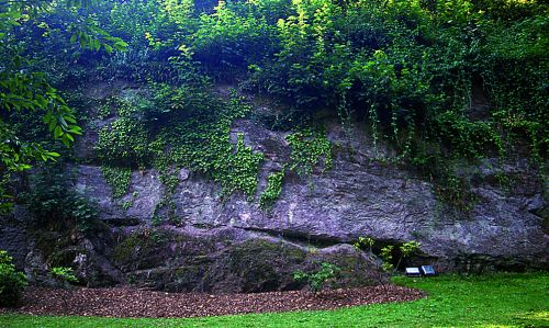

Im Heidelberger Schloß ist in der Südwand des Schlossgrabens zwischen Krautturm und Brückenhaus ein geologisch bedeutendes Profil zu sehen, das die Grenze Grundgebirge zu Deckgebirge deutlich zeigt: der untere Teil besteht aus so genanntem „Heidelberger Granit“ , ein mittelkörniger Granit mit porphyrischer Struktur, der auf 350 Millionen Jahre geschätzt wird.
Darüber folgt eine deutliche, von links nach rechts einfallende Kerbe, die die ganze Wand durchschneidet. Sie markiert eine Schichtlücke, in der die höheren Teile des Granits der Erosion zum Opfer gefallen sind. Dadurch stellt die Granitoberfläche gleichzeitig auch die damalige Landoberfläche vor 250 Millionen Jahre dar, die anschließend von den Sandströmen des Rotliegend (permisches Deckgebirge) überschüttet wurde. Diese Sandströme verfestigten sich zu dicken, mit dem Granit gleichsinnig einfallenden Bänken aus dunkelroten Arkosesandsteinen mit Feldspäten und Rhyolith-Bruchstücken.
Der Zugang zum Schlossgraben ist frei, es muss kein Eintritt bezahlt werden!
!!! Zusatz für die Winterzeit !!!
Bei Schnee und Eis ist der Zugang über die Treppe gesperrt.
Anmerkung (03.04.2019): wenn der Zugang gesperrt ist, messt oberhalb der Wand und zieht die geschätzte Höhe der Wand ab ;-)
Logbedingungen:
- Ermittelt die Antworten zu den beiden folgenden Fragen vor Ort
Schickt bitte vor dem Loggen Eure Antworten an meinen GC-Account und loggt direkt online; ich melde mich, falls es Probleme mit den Antworten geben sollte. Logs ohne Antwortmail werden gelöscht.
a) Welche Höhe zeigt Dein GPS an den oben angegebenen Koordinaten?
b) Wie hoch ist das Felsband ungefähr?
- Es wäre schön, wenn du deinem Log ein Foto von dir und deinem GPS-Gerät mit einstellen würdest, bei dem man im Hintergrund das Felsband sieht.

English:
In Heidelberg Castle south wall of the castle tower and bridge gap between herb house is a significant geological profile open, the limit of the basement shows clearly overburden: The lower part consists of so-called "Heidelberg Granite, a medium-grained granite with porphyritic structure, which is estimated at 350 million years.
This follows a distinct, from left to right incident notch which cuts through the entire wall. It marks a hiatus of the higher parts of the granite which fell victim to erosion. Thus, the granite surface also represents the former land surface is 250 million years, which was subsequently overwhelmed by the sand flow of the Rotliegend (Permisches Deckgebirge). These sand flows were thichly solidified, with the granite in the same direction incident benches made of dark red Arkosesandsteinen with feldspars and rhyolite fragments.
Access to the moat is for free.NO entrance fee must be paid.
!!! Add-on for the winter !!!
With snow and ice on the stairs, access is blocked.
Note (03.04.2019): if access is blocked, measure above the wall and subtract the estimated height of the wall.
If you want to log this earthcache:
- You can find the answers to the questions on site.
Please prove your visit to this site by sending the answers to my GC.com account, then you may log, I will contact you in case of problems. Logs without an answer-mail will be deleted.
a) Which altitude is shown on your GPS at the coordinates above?
b) How high is the rock face approximately ?
- It would be nice if you could attach your log a photo of you and your GPS device with the rocks in the background.