HOT - Thermal Water
Logging requirements:
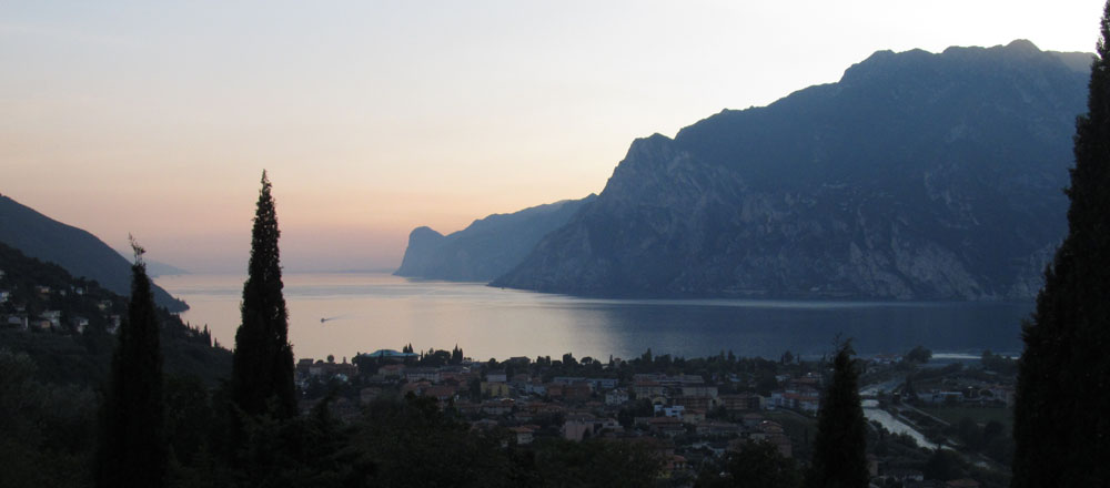
1. Near the GZ, tell me the water temperature of the lake.
2. Now, go to the second point (Platform) and tell me the water temperature of the lake.
3. Why is the water temperature different?
4. Submit a picture from the coordinates, showing you and the lake (OPTIONAL).
Send me the answer by mail, but if you think it’s correct, feel free to make log.
Per registrare la cache:
1. Vicino al GZ, dimmi la temperatura dell'acqua del lago.
2. Ora, passare al secondo punto (Platform) e dimmi la temperatura dell'acqua del lago.
3. Perché è la diversa temperatura?
4. Invia una foto dalle coordinate, che vi mostra e il lago (OPZIONALE).
Inviami la risposta per posta, ma se pensi che sia corretto, si sentono liberi di fare log.
Geology of the Alps and the born of Garda lake
Geologicall y, the Alps were formed during the Oligocene and Miocene epochs as a result of the pressure exerted on the Tethyan geosyncline as its Mesozoic and Cenozoic strata were squeezed against the stable Eurasian landmass by the northward-moving African landmass. The squeezing action formed great recumbent folds (nappes) that rose out of the sea and pushed northward, often breaking and sliding one over the other to form gigantic thrust faults. Crystalline rocks, which are exposed in the higher central regions, are the rocks forming Mont Blanc, the Matterhorn, and high peaks in the Pennine Alps and Hohe Tauern; limestone and other sedimentary rocks are predominant (but not continuously present) in the generally lower ranges to the north and south. Mont Blanc (4,807 m) is the highest peak.
Permanently snowcapped peaks rise above the snowline - located between 2,440–3,050m - and glaciers (the longest being Aletsch glacier) form the headwaters of many Alpine rivers. Glaciation was more extensive during the Pleistocene epoch and carved a distinctive mountain landscape—characterized as alpine—of arêtes, cirques, matterhorns, U-shaped and hanging valleys, and long moraine-blocked lakes (such as Garda, Como, and Maggiore in the south and Zürich, Geneva, Thun, and Brienz in the north).
Thermal water
Thermal water is identified as a hot water with composition rich in salts, iodine and gases. It emerges from natural thermal springs, spread all over the earth and practically on every continent, even in the oceans. In fact, the groundwater coming from hot springs is heated by geothermal processes and naturally flows to the land surface at a temperature of 21°C or above. Geothermal springs can be found at places where magma is close to the surface, primarily in hotspot and volcanic districts or spreading ridge areas. The origin of many thermal springs can be found in aquifers, which are underground layers of rock and sand that contain water. Thermal water can also originate from artesian wells.
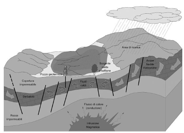
The geothermal mapping of the Italian territory for thermal water whose origin is connected to a fluid circulation within carbonate structural clusters heated by normal geothermal gradient, can be found in the areas between Sirmione and the River Adige Valley and the vast area surrounding the village of Caldiero.
The Thermes
Sirmione Thermes are one of the most important thermal spas in Europe. This facility combines various activities that all have one thing in common – the sulphurous water containing sodium chloride, bromine and iodine. Sirmione’s natural spring of hot sulphuric water is called the Boiola, and the first to speak of it was the monk Giorgio Jodoco Bergano in the little poem Benacus written in 1546.
In 1889, Procopio, a Venetian deep sea diver, equipped with a diving suit and special pumps supplied from England, dived to a depth of 20 meters into Garda Lake. In the area around Catullus' villa, in Sirmione he was the first person to reach a hot water spring which had been known to exist for three centuries.
After several attempts, Procopio succeeded in planting a long tube into the rock face. From the end of this tube, a jet of hot sulphurous water gushed to a height of 5 meters above the surface of the Garda Lake. It was a momentous achievement; this was the first step in the long and difficult process of laying 300 meters of metal pipes, which at last carried the precious thermal waters to Sirmione.
In 1900 the first Spa Establishment was opened, and two new sources were opened at the original Boiola spring. Two further springs were opened, and the thermal water from these springs offered the same chemical and therapeutic properties as the original Boiola spring. The thermal spring water was transported through a network of pipes to several Spa Complexes in Sirminone.
The spring is about 20 meters below ground in Lake Garda and comes from a rocky stratum close to the home of Catullo. Sirmione’s water is mineral which means it has therapeutic properties taken from the minerals in the rocks and it starts on Mount Balso at about 800 meters asl, plunging 2,500 meters below sea level before becoming the Boiola spring and having accumulated its health-giving properties. With a temperature of 69° centigrade when it gurgles out, it contains high levels of sulphur, sodium and iodine. Given these characteristics the water in Sirmione’s baths is used to treat respiratory problems, rheumatism and skin disorders. But the thermal baths on Lake Garda are also popular for the opportunity they give to spend relaxing weekends or longer stays thanks to the interesting SPA packages in wellness centers in Sirmione or in other towns that offer thermal circuits, sauna and steam rooms, massages and mud treatments.
Fonts: Infoplease.com ; Lago di Garda Magazine; EuropeMountains.com; Acque Calde e Geotermia Della Provincia di Verona Aspetti Geologici e Applicazioni.
Geologia delle Alpi e la nascita del Lago di Garda
Geologicamente, le Alpi si sono formate durante l'Oligocene e Miocene epoche a causa della pressione esercitata sul geosinclinale Tethyan come i suoi strati Mesozoico e Cenozoico sono stati schiacciati contro la stalla massa eurasiatica dai nord-africani massa in movimento. L'azione di compressione formata grandi pieghe reclinate (falde) che salivano dal mare e spinto verso nord, spesso rompendo e facendo scorrere una sopra l'altra in modo da formare sovrascorrimenti gigantesche. Rocce cristalline, che sono esposte nelle più alte regioni centrali, sono le rocce che formano il Monte Bianco, il Cervino, e alte vette delle Alpi Pennine e degli Alti Tauri, calcare e altre rocce sedimentarie sono predominanti (ma non sempre presente) in genere inferiore campi a nord ea sud. Monte Bianco (4.807 m) è la vetta più alta.
Vette innevate in modo permanente elevarsi al di sopra del limite delle nevi perenni - trova tra 2,440-3,050 m - e ghiacciai (il più lungo essendo ghiacciaio dell'Aletsch) costituiscono le sorgenti di molti fiumi alpini. Glaciazione era più estesa nel Pleistocene e scolpito una montagna caratteristico paesaggio caratterizzato come alpino di Aretes, circhi, matterhorns, valli a forma di U e appesa, e lunghi laghi morenici-bloccati (come Garda, Como e Maggiore, nel sud e Zurigo, Ginevra, Thun, Brienz e nel nord).
L'acqua termale
Acqua termale viene identificato come acqua calda con composizione ricca di sali, iodio e gas. Emerge da sorgenti termali naturali, diffuse su tutta la terra e praticamente in ogni continente, anche negli oceani. Infatti, la falda proveniente da sorgenti calde viene riscaldata da processi geotermici e fluisce naturalmente alla superficie terrestre ad una temperatura di 70 ° F (circa 21 ° C) o superiore. Sorgenti geotermiche si trovano in luoghi dove il magma si trova vicino alla superficie, soprattutto in hotspot e distretti vulcanici o aree cresta diffusione. L'origine di molte sorgenti termali si trovano nelle falde acquifere, che sono strati sotterranei di roccia e sabbia che contengono acqua. L'acqua calda può anche provenire da pozzi artesiani.
La mappatura geotermica del territorio italiano per l'acqua termale la cui origine è collegata ad una circolazione del fluido all'interno di cluster di carbonato strutturali riscaldati da normale gradiente geotermico, si trovano nelle aree comprese tra Sirmione e l'Adige Valley e la vasta area circostante il villaggio di Caldiero.
Il Thermes
Sirmione Thermes sono uno dei centri termali più importanti d'Europa. Questa funzione combina diverse attività che hanno tutti una cosa in comune - l'acqua sulfurea che contiene cloruro di sodio, bromo e iodio. Sorgente naturale di Sirmione di acqua calda solforico si chiama Boiola, e il primo a parlare è stato il monaco Giorgio Jodoco Bergano nei Benacus poemetto scritto nel 1546.
Nel 1889, Procopio, un palombaro veneziano di mare profondo, dotato di scafandro e pompe speciali forniti dall'Inghilterra, si immerse ad una profondità di 20 metri nel lago di Garda. Nella zona intorno a villa Catullo ', a Sirmione è stato la prima persona a raggiungere una sorgente di acqua calda che era stato conosciuto per esistere per tre secoli.
Dopo vari tentativi, Procopio riuscì a piantare un tubo lungo nella roccia. Dalla fine di questo tubo, un getto di acqua calda sulfurea sgorgava ad un'altezza di 5 metri sopra la superficie del Lago di Garda. E 'stata una conquista molto importante, questo è stato il primo passo nel lungo e difficile processo di posa 300 metri di tubi metallici, che finalmente condotte le preziose acque termali di Sirmione.
Nel 1900 lo stabilimento termale fu aperta la prima, e di due nuove fonti sono state aperte alla fonte originale Boiola. Due molle altre sono state aperte, e l'acqua termale di queste sorgenti offerto la stessa sostanza chimica e le proprietà terapeutiche come la molla originale Boiola. L'acqua termale è stato trasportato attraverso una rete di tubi per diversi complessi termali Sirminone.
La molla è di circa 20 metri sotto il suolo al Lago di Garda e proviene da una stretta rocciosa strato a casa di Catullo. Acqua di Sirmione è minerale che significa che ha proprietà terapeutiche adottate dai minerali delle rocce e si inizia sul monte Balso a circa 800 metri slm, immergendosi 2.500 metri sotto il livello del mare, prima di diventare la sorgente Boiola e dopo aver accumulato la sua proprietà salutari. Con una temperatura di 69 ° centigradi quando gorgoglia fuori, contiene livelli elevati di zolfo, sodio e iodio. Date queste caratteristiche l'acqua nei bagni di Sirmione viene utilizzato per il trattamento di problemi respiratori, reumatismi e disturbi della pelle. Ma le terme del Lago di Garda sono anche popolari per la possibilità che danno di trascorrere rilassanti fine settimana o soggiorni più lunghi, grazie ai pacchetti benessere interessanti centri benessere a Sirmione o in altre città che offrono percorsi termali, sauna e bagni di vapore, massaggi e fango trattamenti.
Font: Infoplease.com; Lago di Garda Magazine; EuropeMountains.com; Acque Calde e Geotermia Della Provincia di Verona Aspetti Geologici e Applicazioni.