Geomon #7 Llanfair PG Blue Schist EarthCache
Geomon #7 Llanfair PG Blue Schist
-
Difficulty:
-

-
Terrain:
-

Size:  (other)
Please note Use of geocaching.com services is subject to the terms and conditions
in our disclaimer.
This Earthcache is part of a series found in the Geopark of Anglesey (Geomôn). This internationally recognised Geopark, the first island ever to receive Geopark status, covers some 720 square kilometres and has 201 kilometres of coastline. With rocks spanning 4 Eras and 12 Geological periods, 1,800 million years of history has fashioned more than 100 rock types.
Geological sites (Geosites) have been selected for scientific quality, rarity, aesthetic appeal and educational value. The Geopark Earthcaches series is based around these Geosites. Their interest may also be archaeological, ecological, historical, or cultural.
The Marquis of Anglesey’s Column area is a protected site and no collecting or access with hammers is permitted.
Please check the tides for this cache 
LlanfairPG is famous for the rare Blue Schist best seen in the woodland beneath the Marquess of Anglesey's Column. This rock, originally a pillow lava, was carried down in the earth's crust to great depths at a plate margin.
Under great pressure, but little heat, it was converted (metamorphosised) to the Blue Schist. This is characteristic of what happens to rocks in the subduction zone shown on the diagram. Eventually it resurfaced during great fault movements and why it is found above sea level here.

A Destructive Plate Margin colliding showing The Subduction Zone where Blue Schist is formed
Characteristics of schist are that all traces of the original structure of the rock have been changed and replaced by a hard, layered, material. The texture of Blue Schist is medium-grained, with small crystals. The blue colour of the rock comes from the presence of the mineral glaucophane
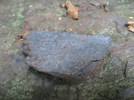
A Fragment of Blue Schist displaying it's natural colour
In order to complete this cache, e-mail the answers to the following (NOTE: Please DO NOT respond to the questions in your logs.):
a) Estimate the height of the exposed rock at N53.13.249, W004.11.831
b) Use your GPS to estimate the height above sea level at GZ
c) Take a photo of yourself and/OR your GPS at GZ (N 53° 13.264 W 004° 11.824)
Whilst here why not visit The Marquess of Anglesey's Column, note it is made of limestone and not Blue Schist! It stands at 27metres high and was erected in 1816-17 as a tribute to the Marquess, Henry Paget, (1768-1854) who lost a leg at the battle of Waterloo.
Access is available to the column for a small charge and a climb of 155 steps!
The view from the top is superb on a clear day, reaching far over the Menai Strait to Snowdonia.
If you wish, though this is not necessary to complete the cache - just an excuse to take in the scenery and enjoy a walk- continue down to the shore line following the footpath to the road, careful when crossing, and follow signs to St.Mary's Church and the Isle of Anglesey Coastal Path.
Alternatively park at St. Mary's church and do it in the reverse order.
At the shoreline you can find many large boulders (erratics) of Blue Schist that have been carried by the ice and deposited on the shores of the Menai Strait.
Further information on the geology of Anglesey can be found on the fantastic Geomôn website:
 Information was sourced from literature by Dr Margaret Wood and Dr John Conway of GeoMôn Anglesey Geopark and was used with their permission.
Additional Hints
(No hints available.)