Njut av utsikten. Stigen börjar vid parkeringen./ Enjoy the view. Trailhead at the parking
Längs långa sträckor av Gotlands västkust stiger klippan nästan rakt upp ur havet. Mellan dessa klintområden finns mer lätttillgängliga kuststräckor, men nästan överallt finns en tydlig höjdsträckning längsmed kustlinjen. På sina ställen framstår den mer som en ås, väldigt tydlig t ex norr om Hoburgen (= Häusrygg) och nedanför kyrkan i Fröjel.
Gotland formas
Jordskorpan består av flera kontinentalplattor, som ständigt är i långsam rörelse. För 400 miljoner år sedan befann sig t ex plattan med det som skulle bli Gotland vid ekvatorn. Det hände att den törnade ihop med andra plattor. Följden för ’vår’ platta blev då, att de tidigare tämligen vågräta lagren delvis tippades något överända. När jordskorpan långt senare och efter flera stora och tunga nedisningar började bukta upp igen, stack ön upp lite ’på sned’ ur Baltiska issjön för ungefär 12 000 år sedan.
Gotland består av bergarter som under årmiljoner bildats som avlagringar på botten av olika hav som alla var tämligen grunda. Djur som levde då hittar man nu förstenade som fossil lite överallt på ön men mest längs kusterna.
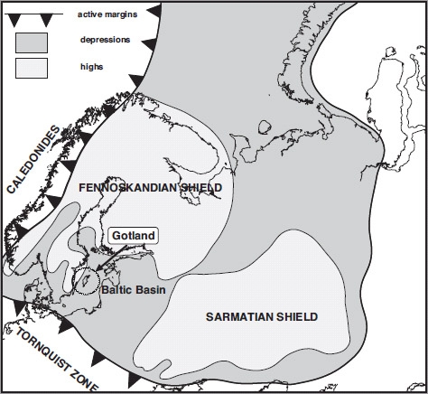
Gotland uppvisar en även med internationella mått mätt väldigt unik och intressant geologi. Att strosa runt på ön är en exotisk upplevelse eftersom all berggrund man ser är sedimentär och den mesta av denna en nästan obefintligt metamorferad och därmed fossilrik kalksten. Ön är en erosionsrest och i princip helt opåverkad tektonisk vilket gör att de ca 600 meter tjocka kalkstenslagren ligger som de deponerades. Endast en en-gradig lutning (som mest märks vid östkustens klinter) finns, vilket gör hela ön till ett extremt flackt landskap. Kullar, åsar och backar finns knappt att tala om.
Bergrunden utgörs primärt av Gotlandikumsk kalksten (dvs 440-415 MA gammal) med de äldsta sedimenten i NV och de yngsta i SÖ (men det finns även spår av sandstenar och ordovicisk kalksten. Detta avspeglas till viss del i fossilmaterialet. Olika sorters fossil är olika vanliga i olika delar av ön även om inlandsisen har flyttat runt på de flesta fynd. Den ö vi ser idag är allt som återstår av en mycket större sedimentär avlagring från ett större hav som vid Gotlandikum befann sig omkring ekvatorn. Ger man sig ut och letar på andra platser måste man i regel borra sig ner genom yngre sediment. I Polen finns tex upp mot 3 km tjocka Gotlandikumsk sediment som jämförelse. Men de är begravda under yngre sediment och inte på samma sätt exponerade vid ytan.
Den här flacka berggrunden har också lett till att nästan inga kvartära sedimentavlagringar finnes. När inlandsisen drar fram över ön så ansamlas väldigt lite sediment under isen då inga dalar eller toppar finns som sedimenten kan ansamlas kring. Det leder till en miljö där det idag på stora delar av ön bara finns centimetertjocka jordar. Perfekt miljö för karga hedväxter och tallar men värdelös för bördiga grödor och högväxande skog. Det är alltså inte så konstigt att så många bönder på ön ägnar sig åt får och inte odling.

Landhöjningen efter den senaste nedisningen har nu upphört på Gotland, men den håller fortfarande på i norra delarna av Sverige.
Utsiktsplatsen Haugklintar
Hitta dit:
Från rastplatsen vid väg 140, några hundra meter norr om Fröjel kyrka, går man tvärs över vägen och följer den stig som börjar där. Håll vänster direkt i första stigskälet efter 50 meter och sedan också tre hundra meter längre fram. Följ den väl upptrampade stigen ytterligare 300 meter, och du är framme vid utsiktvyerna!
Fröjel Hembygdsförening har mer info/More info at: (visit link)
KRAV FÖR ATT LOGGA CACHEN:
Skicka svar på fråga 1 till 3 via e-post från denna cachesida innan du loggar.
1) Perioden för Gotlands bildande kallades fordom för Gotlandikum. Vad kallas denna period för nu?
2) Från utsikts platsen ser man två Naturresarvats öar. vad heter dessa?
3) Vid platsen du står vid finns en informationsskylt. vem har satt uppskylten?
4)Frivilligt: Ett uppladdat foto i loggen från platsen med dig och/eller din GPS på bild.
In English
Along long stretches of the west coast of Gotland rises almost straight up the cliff from the sea. Between these cliff areas are more readily available coastline, but almost everywhere is a clear height of tension along coastline. In some places appear it more like a ridge, a very clear example north of Hoburgen (= Häusrygg) and below Church of Fröjel.
Gotland shaped
The crust is composed of several tectonic plates, that is continuously in slow motion. For 400 million years ago were such as plate with what would become of Gotland equator. It happened that it bumped up with other tiles. The consequence of 'our' flat was then that the former rather horizontal layers partially tipped something over. When the crust much later and after several large and heavy glaciations began curl up again, then thrust the island up a bit 'askew' from the Baltic Ice Lake about 12 000 years ago.
Stored rocks with fossils Gotland consists of rocks formed over millions of years as stuck at the bottom of the various seas that all was fairly shallow. Animals that lived then you will find now petrified that fossils all over the place on the island but most along the coasts.
Gotland exhibits an even by international standards very unique and interesting geology. To stroll around the island is an exotic experience because all you see are rocks sedimentary and most of this one almost nonexistent metamorferad and thus fossilrik limestone. The island is an erosion of town and basically unaffected tectonic making them about 600 feet thick limestone layers is that they were deposited. Only a one-degree angle (most noticeable at the east coast dunes) are available, making the island an extremely flat landscape. Hills, ridges and hills are barely worth mentioning. The bedrock consists primarily of Gotlandikumsk limestone (ie 440-415 MA old) with the oldest sediments in the NW and the youngest in SU (but there are also traces of sandstones and Ordovician limestone. This is reflected in some of the fossil material. Different kinds of fossils are different common in different parts of the island even if the ice sheet has been moved around on most deals. the island we see today is all that remains of a much larger sediment from a major ocean at Gotlandikum were around the equator. involves going out and looking elsewhere, must usually drill down through the younger sediments. in Poland for example up to 3 km thick sediments Gotlandikumsk for comparison. But they are buried under younger sediments and are not just exposed at the surface. This flat bedrock has also led to almost no quaternary sediments there. When the ice pulls up across the island to accumulate very little sediment under the ice when no valleys or peaks is that the sediments can accumulate around. This leads to an environment where today large parts of the island is only centimeter-thick soils. Perfect setting for barren hedväxter and pines, but useless for fertile crops and tall trees. So it is no wonder that so many farmers on the island devoted to sheep and not growing.
It is these formations which today stands as sea stacks. The oldest is therefore rauks in the northwest, the Faroe Islands, in Lickershamn, the youngest is on the southeastern island of Gotland.
It is these formations which today stands as sea stacks. The oldest is therefore rauks in the northwest, the Faroe Islands, in Lickershamn, the youngest is on the southeastern island of Gotland.
From Haugklintar has the best view of Fröjel entire shoreline, Gannarve Bay and Charles Islands outside.
Bring binoculars, a picnic basket and a blanket, but its not too near the edge ...
Uplift after the last glaciation has now ended on Gotland, but it is still in northern parts of Sweden. The viewpoint Haugklintar
Find it: From the rest area on route 140, a few hundred meters north of Fröjel church, you go across the road and follow the trail that starts there. Keep left directly in the first rise reason for 50 yards and then also three hundred meters later. Follow the well-trodden path further 300 meters, and you reach the views views!
LOGGING REQUIREMENTS:
Send response to question 1-3 by e-mail from this cache page before logging.
1) Period of Gotland formation was called once for Gotlandikum. What do you call this period now?
2) From the viewpoint you can see two Naturresarvats islands. what is the name of these?
3) There is an information sign at the place you are standing at. who has put up the sign?
4) Optional: A photo uploaded in the log from the scene with you and / or your GPS in the picture.
Lycka till!! /
Moberg