

Come on a journey to remember and commemorate the history and
travels of Captain John Smith!
Over four
hundred years ago, Englishman John Smith and a small crew set out
in an open boat to explore the Chesapeake Bay. Between 1607 and
1609 Smith mapped and documented nearly 3,000 miles of the Bay and
its rivers. Along the way he visited many thriving American Indians
communities and gathered information about this “fruitful and
delightsome land.” In December 2006 the U.S. Congress
designated the routes of Smith’s explorations of the
Chesapeake as a national historic trail—the first national
water trail.
Are you ready
to follow in the wake of Captain John Smith? Visit sites along the
National Historic Trail and learn about the native cultures and the
natural environment of the 17th-century Chesapeake through the
Captain John Smith Chesapeake Geotrail. The Trail provides
opportunities for you to experience the Bay through the routes and
places associated with Smith’s explorations. Caches will be
located in museums, refuges, parks, and towns in Virginia, Maryland
and Delaware along the rivers and creeks that Smith and his crew
explored four centuries
ago.
The Captain John Smith (CJS) Geotrail launched June 4, 2011 with
over 30 caches within Maryland, Virginia and Delaware. A trackable
geo coin will be awarded to the first 400 geocachers, while
supplies last, for locating at least 15 CJS caches. To be eligible
for the coin, geocachers must download a passport from either the
CJS Geotrail or Maryland Geocaching Society website.
Geocachers must find and log at least 15 finds, record the code
word from each cache on their passport and post a picture of
themselve at each cache location. After discovering the 15
required caches, geocachers may have thier passports validated in
person or via mail at the National Park Service, Chesapeake Bay
Office located at 410 Severn Ave, Suite 314, Annapolis, MD 21403.
Please refer to the passport for complete validation
instructions.
Participating in the CJS geotrail is fun and we hope that many
people join in. However, it is not a requirement for logging your
find on this cache once you find the container.
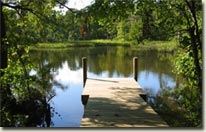
This puzzle/multi cache will lead you to a Lock & Lock
container stocked with a variety of CJS items. At the posted
coordinates, cachers will need to count the number of decking
boards. There are two lengths of boards. Count the number of long
boards and the number of short boards.
Add 10 to the number of long boards and subtract this number from
the posted north coordinates.
For the west coordinates, subtract the number of short boards from
the posted west coordinates.
These coordinates will lead you to stage 2.
At stage 2, search and you will find the coordinates for the
final.
Powhatan Creek is a 23 mile tributary of the James River that
passes through an area recognized as one of the most
environmentally significant natural resource areas in southeastern
Virginia. The creek is still largely undeveloped and a great place
to paddle and fish (with license). Scenic views of tidal marshes
and an abundance of wildlife highlight trips on this beautiful
waterway. Herons, egrets, and eagles are frequently seen, and in
the fall the fresher upper marshes yield acres of wild rice, a
prime attraction for migratingducks and geese.
Creeks such as this one would have supplied local Indians with
fish, muskrats, otter, and waterfowl as well as tuckahoe (arrow
arum), wild rice, and marsh grasses. Waterways also served as
roads, moving people, goods, and information up and down the
creeks, rivers, and streams – first Indians in canoes and
later the English in barges and other boats. Among the historic
sites along the Powhatan Creek are Greensprings Plantation and
Mainland Farm.
The Blueway currently has only one public access point, located off
Jamestown Road. The trail is not marked, but the trip is a straight
paddle downstream to Jamestown Island (no takeout here) and back to
the point of origin. Total roundtrip is about 18 miles to the
confluence of the James River and return.
The creek is named after Powhatan, paramount chief of the Powhatan
Confederacy, whose proper name was Wahunsenacawh. When the English
arrived in 1607, Powhatan ruled over a broad territory that
included a confederacy of more than 20 tribes. While initially
friendly to the settlers, Powhatan moved his capital some distance
from Jamestown only a few years after their arrival, owing to the
colonists’ demands for corn and repeated infringements on his
peoples’ territories. The marriage of his daughter Pocahontas
to John Rolfe in 1614 led to a fragile peace, but four years after
Powhatan’s 1618 death, his brother led an uprising that
killed approximately one-third of the English
colonists.

Thanks to Great
Scott! for helping with this hide and to the Maryland
Geocaching Society for assisting with this
project!