Steinbruch Flechtingen (EC) EarthCache
Steinbruch Flechtingen (EC)
-
Difficulty:
-

-
Terrain:
-

Size:  (other)
Please note Use of geocaching.com services is subject to the terms and conditions
in our disclaimer.
|

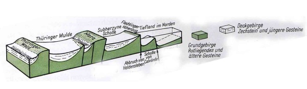
Der Flechtinger Höhenzug erstreckt sich nordwestlich von Magdeburg.
Er stellt, ähnlich wie der Harz eine Kippscholle dar und wird im Nordosten durch den Haldenslebener Abbruch begrenzt.
Eine der höchsten Erhebungen des Flechtinger Höhenzugs ist mit 176 Meter der Butterberg nahe des Ortes Ivenrode.
Regionalgeologisch ist der Höhenzug ein Teil der Flechtingen-Roßlauer Scholle, die sich im Nordwesten von der Niederung des Drömling nach Südosten bis Magdeburg und weiter nach Roßlau erstreckt. Eine weitere bekannte Aufragung dieser Scholle ist der Magdeburger Domfelsen, der sich auch in der Elbe als Schwelle fortsetzt und die Fließgeschwindigkeit der Elbe merklich erhöht.
|
|
|

The Flechtinger Höhenzug stretches northwest of Magdeburg.
It is like the Harz a tilt clod and in the north- east it is mark off by the Haldenslebener fold.
One of the highest elevations in the Flechtingen Hills is the Butterberg near Ivenrode at 176 m above sea level.
Regionally the ridge is part of the Flechtingen-Roßlau Scholle, that runs in the northwest from the depression of the Drömling towards the southeast to Magdeburg and the river Roßlau. Another well-known ridge in this Scholle is the Magdeburg Domfelsen, which acts as a sill to the Elbe and markedly raises its water velocity.
|
|
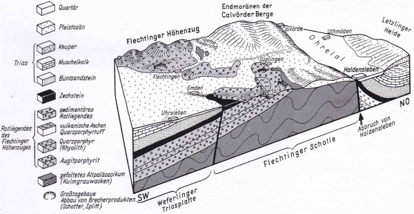
Anders als in seiner Umgebung stehen im Flechtinger Höhenzug geologisch alte Gesteine an der Erdoberfläche an. Er bildet damit eines der nördlichsten Vorkommen von Festgestein in Deutschland, da Norddeutschland fast völlig von Lockergesteinen des Quartärs bedeckt wird. Der Höhenzug wird meist von vulkanischen Gesteinen und Sedimentgesteinen aus dem Karbon und Perm aufgebaut.
|
|
|
Unlike the surrounding region, geologically old rocks reach the surface of the Flechtingen Hills. It thus forms the northernmost region of bedrock in Germany, because North Germany is almost completely covered by unconsolidated rocks of the Quaternary era. The ridge is mostly composed of volcanic rock and sedimentary rocks of the Carboniferous and Permian periods.
|
|
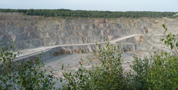
Die Hartgesteine des Flechtinger Höhenzuges sind im Umkreis und darüber hinaus im Norddeutschen Tiefland gefragte Rohstoffe. Andesitoide und Rhyolithe werden in Großsteinbrüchen zu hochwertigen Schottern gebrochen oder zu Dekorationszwecken abgebaut. Sandsteine sind begehrte Bau- und Werksteine.
Gefördert wird ein Quarzporphyr, der hauptsächlich in grünlichgrauer, braungrauer und seltener in rötlicher Färbung vorkommt. Er überzeugt durch eine besondere Härte.
Die Lagerstätte bildet schon seit über 100 Jahren den nördlichsten Hartsteinabbau Deutschlands. Um 1890 wird dann mit dem gewerblichen Abbau begonnen. Die Bruchsteine wurden hauptsächlich im Straßenbau verwendet.
1994 wird das neue Schotter- und Splittwerk mit einer Produktion von bis zu 3 Millionen Tonnen pro Jahr gebaut. In den letzten Jahren wurde in die Optimierung des Abtransportes der Hartsteinerzeugnisse mit Bahn und Schiff investiert.
|
|
|
The hard stones of the Flechtinger Höhenzüges are very much in demand in the local region and also beyond in the North German Lowland. Andesitoites and ignimbrites are mined in large stone quarries and are broken down into quality gravel or are used for decoration. Also sandstones are demand stones for building.
It supports a quartz porphyry, which occurs mainly in greenish-gray, brownish gray and more rarely in reddish color. It delivers an exceptional hardship.
The deposit forms for over 100 years. It is the northernmost hard stone degradation of Germany. Around 1890, started the commercial degradation. The broken stones were used in road construction.
In 1994, the new gravel and grit with a production plant is built up to 3 million tons per year. In recent years it has invested in the optimization to the transport of the stone products by train and ship.
|
|
Log-Bedingungen
Um die Logerlaubnis zu erhalten, müsst ihr mir die Antworten auf folgende Fragen mailen:
1. Wann wurden hier die ersten Steine und für welches naheliegende Bauwerk gebrochen?
2. Aus welcher Gesteinsart besteht der Flechtinger Höhenzug?
3. Am Wegpunkt 'Auffaltung' sind an der Oberfläche einige Gesteinsschichten zu erkennen. Wie stark sind sie ungefähr?
4. und messt die Ausdehnung des Steinbruches von der Besucherplattform in Richtung Norden.
Bis die Tafeln an der Anssichtsplatform wieder vorhanden sind, findet die Antworten zu den ersten beiden Fragen hier...Tafel 1, Tafel 2
Es wäre schön, wenn ihr als Beweis, dass ihr dort wart, ein Foto von euch und der Plattform hoch ladet.
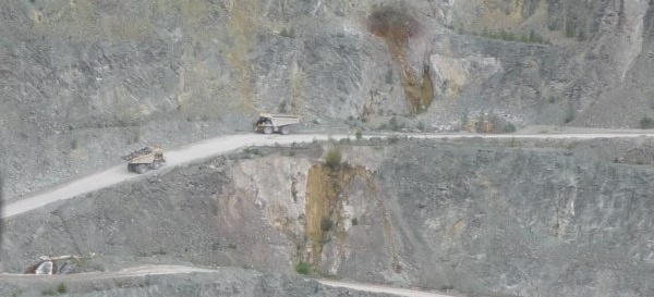
Viel Spaß beim Sammeln der Antworten und beim Beobachten der kleinen Autos!
|
|
|
log requirement
To get the log permission you have to mail me the right answer of the following questions:
1. When there were the first stones broken and for which obvious structure?
2. Witch kind of stone the Höhenzug consist of?
3. At the waypoint 'Auffaltung' You can see layer at the ground level. How massive just about they are?
4. and scale the expansion of the quarry from the visitors' platform into the North.
The information boards at the visitors' platform are still lost. You find the answers for the first tow questions here...Tafel 1, Tafel 2
It would be nice, if you post some photos of you and the visitors' platform.
Happy searching the responses and looking the small trucks!
|
Additional Hints
(No hints available.)