Things you will need to log this Earthcache:
- Camera
- GPS
- Tape measure or ruler
Due to the higher water levels of Lake Superior, the logging requirements have been updated. The logging requirements for this Earthcache are:
- Post to your online log a photo of your GPS with the shoreline and rock cliff in the background. Your face can be included if you so wish.
E-mail me, via my profile, the answers to the following questions:
- Estimate the height of the rock cliff.
- Estimate the angle from horizontal of the rock layers.
Definition of Terms
Conglomerate
Is a sedimentary rock that contains rounded rocks 1/16" in diameter or larger. The spaces between the rounded rocks is filled with sand, mud and/or a chemical cement that binds the pieces together.
Strong water currents are needed to move rocks of these sizes. A swiftly flowing stream or a beach with strong waves will have enough energy to deposit this mix of rock sizes. The rounded shaped rocks show that they were eroded by moving water.
Cross bedding
Are structures formed in a horizontal depositional land form. They are formed by a fluid such as air or water flowing over them. Sediment grains bounce up the windward/upstream side of a ripple, and then tumble down the lee side. It is most common in stream deposits (consisting of sand and gravel), tidal areas, and in some dunes.
Cross bedded sediments are recognized in the field by the many layers of "foresets", which are the series of layers that form on the lee side of the ripple or dune. These foresets can be identified from the separation between layers of material of different sizes and densities. Check out this link for a Cross Bedding Animation. More animations can be played from here.
Feldspar
Is the most common rock forming mineral. About 60% of the earth's crust is feldspar. Feldspar minerals are usually white or very light in color. It is more commonly found in igneous and metamorphic rocks, but can be found in sedimentary rocks also. The name feldspar is from the German words "feld" and "spar". The word "feld" is "field" and "spar" is a term for light colored minerals that break with a smooth surface.
Rift
Is where the Earth's crust or lithosphere (outermost shell) is pulled or stretched apart. Most rifts have volcanoes and lava flows. The animation of rifting can be seen at this link. Rifting is the process that oceans are formed by.
Geological History
The earth was a very different place 1.1 billion years ago. To the north and west you would have been looking at a great rift valley. It runs for 1,243 miles from Kansas to southern Canada and back down to southeast Michigan. Rifts are what splits continents apart.
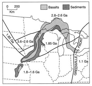
The Mid-Continent Rift.
As the rift widen, it collected water and was filled with various sediment layers. Most geologist believe that to the north and west of the posted waypoint was an inland sea (in the rift) and to the south and east, mountains that were called "The Michigan Highlands". From these mountains, eroded rock was being carried by rivers to this inland sea. About 1.07 - 1.08 billion years ago a layer of sediments were deposited which we call the "Freda Sandstone".
Freda Sandstone is colored red, brown, and tan with minor shale and conglomerate beds. Mostly fine to medium grained feldspar, quartz, chert, and quartzite. Mica is also a common component. Well bedded and commonly cross bedded.
Then in a blink of an eye in geologic time, 15 to 22 million years the rifting stopped. The Earth's crust stopped pulling apart and started to push the rift closed. The rift was only closed a small amount, but enough to push the sedimentary rock layers into the Lake Superior syncline. A syncline is a downward folding or bending of rock layers. This "bowl" shaped feature forms Isle Royale and the Keweenaw peninsula.
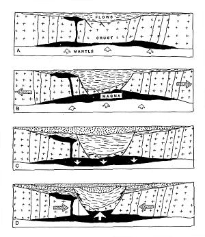
The Mid-Continent Rift - Cross Section.
A feature that can be found in a variety of sedimentary rocks is ripple marks. Which are small waves that form on the surface of sediments caused by water or air currents. These would have formed in shallow water near a shoreline where the wave action can affect the surface of the sediments. There are examples of ripple marks here.
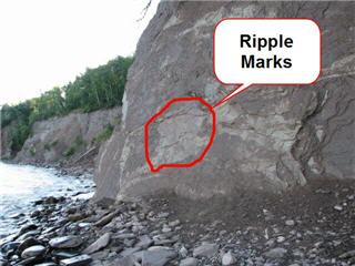
Location of ripple marks.
Look at the cliff face and find the ripple marks. Does anything seem strange about their position? Yes, there is something strange, the ripple marks are no longer laying flat as they would formed on the bottom of shallow water. They have been tilted. This tilting is result of the Lake Superior syncline.
References used:
- http://tin.er.usgs.gov/geology/state/state.php?state=MI
- http://walrus.wr.usgs.gov/seds/bedforms/animation.html
- http://geology.com/rocks/conglomerate.shtml
- http://www.wwnorton.com/college/geo/earth3/content/ch4/animations.asp