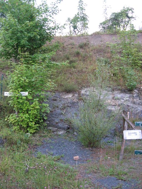
Posidonienschiefergrube EarthCache
-
Difficulty:
-

-
Terrain:
-

Size:  (other)
Please note Use of geocaching.com services is subject to the terms and conditions
in our disclaimer.
Posidonienschiefergrube - The Posidonia Shale Pit

Deutsche Version:
Die Posidonienschiefergrube befindet sich am westlichen Rand des Hesselberges,
dem höchsten Berg Mittelfrankens.
Der Hesselberg ist vor ca. 200 Millionen Jahren als Inselberg im Jurameer entstanden. Er besteht gelogisch aus 3 Hauptschichten, schwarzer, brauner und weißer Jura mit Einlagerung von Ölschiefer.
Diese Schiefergrube ist ein "geologisches Naturdenkmal" und Teil des "Geologischen Lehrpfades Hesselberg".
Der Posidonienschiefer, auch Ölschiefer genannt,
entstand in der flachen Randzone des Jurameeres im Erdmittelalter, dem Mesozoikum.
Das hier abgestorbene, organische Material rieselte nach unten und bildete mit anderen Stoffen einen Faulschlamm. Hieraus entwickelte sich während langer Zeiträume, bedingt durch den Sauerstoffmangel, der Ölschiefer.
Der Ölschiefer ist bekannt für seine herausragende Fossilerhaltung. Man findet aufgrund des sauerstoffarmen und teilweise anoxischen, sogenannten euxinischen, Milieus zur Zeit der Ablagerung sehr gut erhaltene Seelilien, Ammoniten, Fische und Ichthyosaurier.
Gehe zur Infotafel bei N 49° 04.042 E 010° 29.577 und beantworte folgenden Fragen:
1.: Wie hoch ist die Opalinuston-Schicht dieser Grube (Infotafel "Posidonienschiefer")?
2.: Erkläre den Namen "Ölschiefer"
3.: Welche Fossilie ist auf der Infotafel "Posidonienschiefer" abgebildet?
4.: Welche beiden Fossilien sind auf der Infotafel "Schwarzer Jura - Lias" abgebildet?
Zur Logfreigabe sende eine Email mit den vier Antworten an mein Profil und warte auf die Logfreigabe.
Optional mache ein Foto von dir oder deinem GPS vor der Schiefergrube und füge es deinem Log bei.
Viel Spass!

English version:
The Posidonia Shale Pit is located at the western site of the mountain "Hesselberg",
the highest mountain in Middle Franconia.
The Hesselberg was originated 200 million years ago as an island mountain in the Jurassic sea. It contains three main layers, black, brown and white Jura with storages of oil shale.
This shale pit is a "geological monument" and a part of the "Geological Trail Hesselberg".
The Posidonia Shale, also called "Oil Shale",
originated in the shallow surface zone of the Jurassic sea in the Mesozoic.
The dead, organic material trickled down and formed a sludge with other materials.
Out of this, in the course of time, the oil shale was built on the basis of oxygen starvation.
The oil shale is known because of its prominent fossil preservation. Because of the low oxygen, and partially anoxic environment , its easy to find well-preserved sea lilies, ammonites, fish and Ichthyosaurs
Go to the information board at N 49° 04.042 E 010° 29.577 and answer the following questions:
1st: What is the hight/thickness of the "Opalinuston layer" in this pit (info panel "Posidonia slate")?
2nd: Explain the name "oil shale".
3rd: Which fossil is showed on the info panel "Posidonia slate"?
4th: Which two fossils are showed on the info panel "Black Jura - Lias"?
For logging this cache, send an eMail with the answers to my profile and still wait for a reply =).
Optinal take a photo of you or your GPS in front of the slate pit and add it to your log.
Have fun! |
|
Additional Hints
(No hints available.)