
 Der „Geologische Lehrpfad“ am Schlossberg beginnt am Parkplatz der Firma Junghans und führt hinauf zur Burgruine Hohenschramberg. Auf 14 Schautafeln wird die Geologie des Berges und der Gegend erklärt.
Vor ca. 215-205 Millionen Jahren sank das Germanische Becken in dem sich der Buntsandstein abgelagert hatte ab. Im Raum Schramberg am Rande des Germanischen Beckens war die Buntsandsteinschicht ca. 150m hoch. Ein Meer bildete sich.
Vor ca. 145 Millionen Jahren zog sich das Meer aus Südwestdeutschland zurück. Die Landoberfläche bildeten mächtige Kalksteinschichten.
Der Schwarzwald hob sich vor allem in der Erdneuzeit (in den letzten 65 Millionen Jahren).
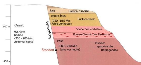
Durch die Verwerfung am Schramberger Schlossberg liegen verschiedene Gesteinsarten nebeneinander. Siehe Schaubild.
Es gibt noch sehr viel mehr zu entdecken und erfahren. Mach Dich auf. Der gesamte Geologische Lehrpfad geht über ca. 200 Höhenmeter! Auf dem Rückweg kannst Du noch den Lehrpfad über die lokale Vegetation besuchen.
 The „Geologic Trail“ at the Schlossberg starts at the parking area of „Junghans“ (a local company). It leads all the way up to the castle ruin Hohenschramberg. On 14 presentation boards the geology of the area is explained.
215 to 205 million years ago, the German Basin was full of bunter. In Schramberg its height was approx. 150 m. Then it sank and the sea covered the whole area.
Approx. 145 million years ago, the sea vanished from the area now known as south west germany. The surface was built by huge limestone layers.
The black forest raised mainly during the last 65 million years.
Due to the dislocation at the Schramberger Schlossberg different types of rock can be found on the same level.
There is a lot more to discover on the trail. On the way back you can also visit the trail with information on local vegetation.
Jetzt noch zu den Fragen: Um diesen Earthcache zu loggen, mußt Du ein Foto von Dir und/oder Deinem GPS vor der Formation an Schautafel 12 machen. Sende mir bitte die Antworten auf die unten stehenden Fragen per e-mail (NICHT ÜBER DEN NEUEN MESSENGER) zu (keine Antworten in den Log schreiben). Bitte warte nicht mit dem Log auf die Logfreigabe.
1. In welcher Höhe setzt am Schlossberg der Buntsandstein ein? (Bitte Angabe von Schautafel 9)
2. Bei Schautafel 7 gibt es eine weitere Informationstafel zu einem bestimmten Tier. Wie ist sein Name?
3. Von unten kommend gibt es kurz vor Schautafel 12 Stufen. Wie ist ihre Anzahl?
And here are the questions: To log this Earthcache, take a photo of yourself and/or your GPS in front of the formation near presentation board 12 and send me the answers to the following questions in an email (NOT VIA THE NEW MESSENGER). Please do not wait with your log until you got an e-mail.
1. What is the elevation where the bunter starts in the Schlossberg area? (Please use the information from presentation board 9)
2. Near presentation board 7 there is an additional information board on a local animal. What is the name of the animal?
3. Coming up from below there are some steps leading to presentation board 12. How many steps are there?