Der Kühsteinfelsen
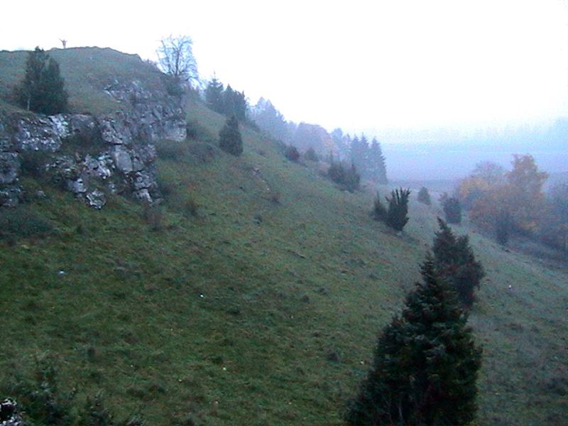

Bei den Kühsteinfelsen handelt es sich um sogenannte Stotzen (teilweise herauspräparierte, dolomitisierte Felsen einer Jurascholle), die nach Süden geneigt ist und an der Kraterrandzone nach Norden aber steil zum Rieser Meteoritenkessel abfällt. Sie stellt eine Fortsetzung des Reisbergs nach Osten dar. Die Felsen sind Teil einer Schwamm-Algen-Riffbildung (Weißjura delta bis zeta), die von einer dünnen Bodenkrume und einer Flora des Trockenrasens und der Wacholderheide bedeckt sind.
Der Malm-Dolomit
Der Dolomit ist ein Karbonat-Gestein, das zu mindestens 90 Prozent aus dem gleichnamigen Mineral Dolomit besteht. Bei geringeren Gehalten an Dolomit liegt ein dolomitischer Kalkstein vor. Es ist im Idealfall weiß, häufig aber elfenbeinfarben, hellgrau, graugelb oder grüngrau. Dolomitsteine sind im Vergleich zum chemisch verwandten Kalkstein etwas härter, aber sehr viel spröder.
Geografische Lage
Der Kühsteinfelsen liegt im südlichen Teil der Frankenalb (auch Frankenjura) und ist somit geologisch dem Frankendolomit zuzuordnen.
Die Fränkische Alb ist die geologische Fortsetzung von Schweizer Jura und Schwäbischer Alb.
In der Zeit des Weißen Jura lag vor etwa 161 bis 150 Millionen Jahren ganz Süddeutschland im Bereich eines Flachmeeres. Wegen ständiger Absenkung der Kruste wurden als Folge mächtige Gesteinsfolgen am Meeresgrund abgelagert. Die Jura-Sedimente bilden noch den größten Anteil der Gesteine, im Wesentlichen Kalkstein, und sind Grundmaterial der Fränkische Alb.
Durch Hebungen der europäischen Kontinentalplatte gegen Ende des Oberen Jura zog sich das Meer zurück und größere Flächen wurden zu Beginn der folgenden Kreidezeit zunächst Festland. Während dieser Zeit herrschte tropisches Klima und es kam zu einer intensiven Verwitterung der vorher entstandenen Kalk- und Dolomitgesteine.
In der Zeit der Oberkreide stieß erneut ein Meer in den Bereich der Fränkischen Alb vor.
Im Tertiär erfolgte durch regionale Hebung abermals ein Meeresrückgang, sowie eine teilweise Freilegung der Juralandschaft.

 Wir würden uns über ein Foto von Dir und Deinem GPS freuen (optional).
Logbedingung:
1. Messe die Höhe mit dem GPS an der Koordinate N48°46.395, E010°34.338!
2. Beschreibe kurz die Struktur und Farbe des Gesteins.
3. Nenne die chemische Formel des Dolomit-Minerals.
Sende die Antworten aus Frage 1 bis 3 an Fam.Weiss mit deinem GC-Namen (Nickname) in der Betreff-Zeile. Wir melden uns, wenn etwas nicht stimmt.
Achtung - Bitte beachten!
Bitte schreibt die Antworten keinesfalls in Euren Log!
Logeinträge ohne Beantwortung der Fragen werden von mir ohne Nachfrage gelöscht!
Achtung: Je Account ist eine Antwortmail zu senden, um die Logbedingung zu erfüllen! Eine „Sammelantwortmail“ für mehrere Accounts erfüllt daher nur die Logbedingung für den jeweiligen Absender! Die Logs der anderen Accounts werden kommentarlos gelöscht!

With the Kühsteinfelsen it acts around so-called Stotzen (dolomite partly prepared rock of a Jura layer), which is bent to the south and drops at the crater edge zone northward however steeply to the Ries meteorite boiler. It represents a continuation of the Reisberg eastward. The rock are part of a sponge alga reef formation (white jura delta to zeta), which are covered of a thin top soil and a flora of the drying lawn and the juniper heather.
The Malm-Dolomite
The dolomite is a carbonate rock, which consists to at least 90 per cent of the mineral of the same name dolomite. With smaller contents of dolomite a dolomite limestone is present. It is ideally white, frequently however ivory colors, light-grey, grey-yellow or green grey. Dolomite rocks are in the comparison to the chemically used limestone somewhat harder, but a lot of brittle.
Geographical layer
The Kühsteinfelsen is appropriate in the southern part of the Franconia Alb (also franc jura) and is thus geologically for the franc dolomite to be assigned. The Franconia Alb is the geological continuation of Swiss Jura and Swabian Alb. In the White Jura time completely South Germany was appropriate in the range of a flat sea before approximately 161 to 150 million years. Because of constant sinking of the crust as consequence powerful rock sequences were deposited at the sea-bottom. The jura sediments form still the largest portion of the rocks, essentially for limestone, and are base material of the Franconia Alb. By elevations of the European continental plate toward the end of the Upper Jura the sea withdrew itself and larger surfaces became at the beginning of the following chalk time first mainland. During this time tropical climate and it prevailed came to an intensive decomposition of the lime and dolomite rocks developed before. In the time of the Upper Chalk again a sea advanced into the range of the Franconia Alb. In the Tertiary period again a sea decrease, as well as a partial opening of the jura landscape took place via regional elevation.

We would appreciate a photo of you and your GPS.
Log conditions:
1. Measure the height with your GPS at the coordinates N48°46.395, E010°34.338.
2. Describe briefly the structure and color of the rock.
3. Tell us the chemical formular of the dolomite mineral.
Send the answers of the question 1 to 3 to Fam.Weiss with your GC-name in the subject-line. We contact you if something is wrong.
Attention – Please note!
Please don´'t write the answers into your internet-log at GC!
Log entries without answering the questions will be deleted by us directly without any further enquiry!
Attention: To fulfill the log condition you have to send a reply mail with the answers for the questions per Geocaching account! A "multiple answer mail" for several Geocaching accounts therefore only fulfills the log condition for the respective sender! The logs of the other accounts are deleted without comment!