Cirque de Navacelles EarthCache
-
Difficulty:
-

-
Terrain:
-
Size:  (not chosen)
Please note Use of geocaching.com services is subject to the terms and conditions
in our disclaimer.
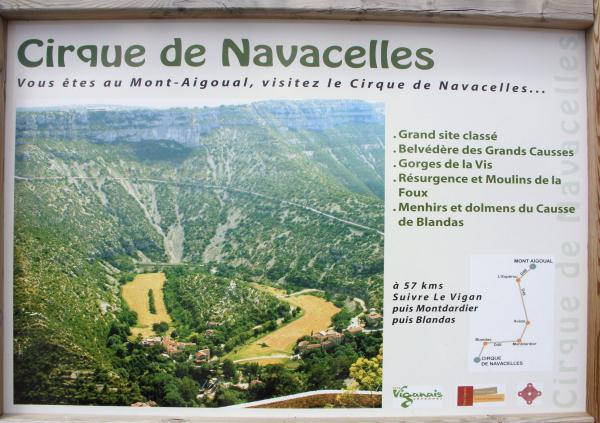
Cirque de Navacelles is a beautiful environment, offering a great
geologic experience. On behalve of the Office de tourisme des
Cévennes Méridionales we mention that it needs to be protected (no
rubbish, no fire, etc.)!
________________________________________________________________

Cirque de Navacelles
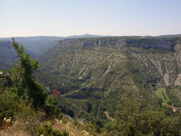
In the middle of the limestone plateaus of Larzac and Blandas is a
magnificent area, known as Cirque de Navacelles, reminiscent of the
Grand Canyon in North America. At this point, the water of the
Vis river founds its way through the limestone. The result is
an impressive canyon where the course of the meandering river may
still be seen. The edges of the canyon offer breathtaking
views. At the bottom lies the medieval village Navacelles,
next to the waterfall in the river Vis. In the area panels can be
found, explaining the geology, flora and human occupation of Cirque
de Navacelles.
Waypoints and questions
For this earthcache to log, the depth and diameter of the canyon
should be calculated. Furthermore you should find out the age of
the canyon and take a picture of yourself (or your GPS) and the
canyon. In order to do this, three places to be
visited. First, the Belvédère de Blandas (WP1). Near the
first waypoint (where you can take a picture of yourself (or your
GPS) with the gap in the background ), is the viewpoint. At
this point can be found the answer to the question: how many years
ago started the formation of the gap? Also note the altitude
of this viewpoint.
The second waypoint is the waterfall near Navacelles
(WP2). Note the waypoint altitude and calculate the depth of
the gorge. The last waypoint is located at La Baume Auriol
(WP3). The coordinates of this viewpoint is not
given. From Navacelles (near the waterfall) is a road up to La
Baume Auriol. You can already see the viewpoint from the
valley, opposite to the view point where you made the
picture. Mark a waypoint at this point and calculate the
diameter of the gap, measured from this waypoint to the first
waypoint.
The answers to the three questions (age gap, gap depth, diameter
gap) should be mailed to us. The cache can be simultaneously
logged, with the aforementioned picture attached. If the
answers are incorrect, the log will be removed after
consultation.
Tip: there are several nice and fun traditional caches in the area.
Please visit them.
***

Cirque de Navacelles
Au milieu des plateaux calcaires entre Blandas et Larzac se
trouvent un magnifique ravin, qui rappelle le Grand Canyon de
l'Amerique du Nord. A cet endroit, l'eau du Vis s'est fraye un
chemin a travers le calcaire. Le resultat est un canyon
impressionnant dans lequel le cours sinueux de la riviere est
encore visible. Les abords du ravin offrent des vues
etourdissantes. Au fond se trouve le village du Moyen Age
Navacelles, a cote de la cascade dans la riviere Vis.
Waypoints et des questions
Afin d'enregistrer cet earthcache, il faut determiner la profondeur
et le diametre du ravin, determiner l'anciennete du ravin et
prendre une photo de ce dernier. Pour cela, trois endroits devront
etre visites. D'abord le Belvedere de Blandas (WP1). Pres de ce
premier "waypoint" (ou tu devras prendre une photo de toi ou d'un
GPS (avec le ravin en arriere plan), se trouve le Belvedere de
Blandas. C'est a ce point de vue que la reponse a la question
suivante peut etre trouvee: A combien d'annees remonte le debut de
la formation du ravin? Note aussi la hauteur de ce point de
vue.
Le deuxieme waypoint se trouve a la cascade pres de Navacelles
(WP2). Note aussi la hauteur de ce waypoint et calcule la
profondeur du ravin. Le dernier waypoint se trouve a la Baume
Auriol (WP3). Les parametres de ce point de vue ne sont pas
indiques. A partir de Navacelles (pres de la cascade), une route
monte vers la Baume Auriol. Tu peux voir le point de vue depuis la
vallee. Il se trouve en face du point de vue ou tu as pris une
photo. Marque un waypoint a ce point de vue et calcule le diametre
du ravin, calcule de ce waypoint jusqu'au premier waypoint.
Les reponses a ces questions (anciennete, profondeur et diametre du
ravin) doivent nous etre envoyees par email. Le cache peut etre
enregistre en meme temps, a condition d'etre accompagne d'une
photo. Si les reponses s'averent inexactes, l'enregistrement sera
annule apres information.
Astuce: Dans le secteur il ya plusieurs belles caches
traditionnels. S'il vous plaît les visiter.
***

Cirque de Navacelles
In het midden van het kalksteen plateaus van Blandas en Larzac
bevindt zich een schitterende kloof, die doet denken aan de Grand
Canyon in Noord-Amerika. Op deze plek heeft het water van de Vis
zich een weg gebaand door het kalksteen. Het resultaat is een
indrukwekkende canyon waar de loop van de meanderende
rivier nog is te zien. De randen van de kloof bieden
duizelingwekkende uitzichten. Op de bodem bevindt zich het
middeleeuwse dorpje Navacelles, naast de waterval in de rivier
Vis.
Waypoints en vragen
Om deze earthcache te mogen loggen dienen de diepte en doorsnede
van de kloof te worden berekend. Hiervoor dienen drie plekken te
worden bezocht. Eerst de Belvédère van Blandas (WP1).
Vlakbij dit eerste waypoint (waar een foto gemaakt moet worden
van jezelf (of GPS) met de kloof op de achtergrond), bevindt zich
de Belvédère van Blandas. Op dit uitzichtpunt kan het antwoord
worden gevonden op de vraag: hoeveel jaar geleden is de vorming van
de kloof begonnen? Noteer ook de hoogte van dit uitzichtpunt.
Het tweede waypoint ligt bij de waterval nabij Navacelles
(WP2). Noteer ook van dit waypoint de hoogte en bereken de diepte
van de kloof. Het laatste waypoint ligt bij La Baume Auriol (WP3).
Het coordinaat van dit uitzichtpunt is niet gegeven. Vanuit
Navacelles (nabij de waterval) gaat een weg omhoog naar La Baume
Auriol. Je kunt het uitzichtpunt al zien liggen vanuit het dal. Het
ligt tegenover het uitzichtpunt waar je een foto hebt hebt genomen.
Markeer op dit uitzichtpunt een waypoint en bereken de doorsnede
van de kloof, gemeten vanaf dit waypoint naar het eerste
waypoint.
De antwoorden op de drie vragen (ouderdom kloof, diepte kloof,
doorsnede kloof) moeten aan ons worden gemaild. De cache mag
gelijktijdig worden gelogd, voorzien van de bedoelde foto. Indien
de antwoorden onjuist blijken te zijn, zal de betreffende log na
overleg worden verwijderd.
Tip: er liggen diverse mooie en leuke traditional caches in het
gebied. Bezoek deze alsjeblieft.

| Team GuitarArnie is a proud |
 |
Additional Hints
(No hints available.)