The first geological base section in Hungary EarthCache
The first geological base section in Hungary
-
Difficulty:
-

-
Terrain:
-

Size:  (not chosen)
Please note Use of geocaching.com services is subject to the terms and conditions
in our disclaimer.
The Triassic sediments in the sea and the Earth hundreds of millions of years fossilized volcano operation world encounter during our walk.
MILLIONS OF YEARS MESSAGES
The Spring Hill geologic "messages" John Böckh geologists discovered in the nineteenth century. Researchers following the work of scientists around the world has become known in this space. Hungary's first geological base section significant interest. The Megyehegy Dolomite Formation is the formation of the Tethys at the time and place just a few meters of the Water depth ancient ocean tidal zone belonged. Catastrophic earthquakes cause the pelvic floor is broken in many places, sunken in these places a little deeper lagoons formed, into which oxygen-rich waters of the open sea is limited to flow. Such a lagoon formed dolomarl. Continued sinking of the seabed, the water deepening, the lagoons are open bays. From these deposits on the lime mud, which formed the limestone Felsoörs. The open sea, they advanced to the deeper water loving, radiolarians even millions, of dead animals migrated from the material dissolved in the mud formed the skeleton of the flint lens, bulbs in the limestone.
TRIASSIC SEA
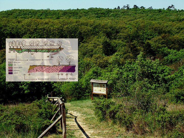
The Lake Highland hills are largely the history of the Earth's Triassic period, about 200-245 million years ago, the Tethys sediments deposited ancient ocean basin solidified rocks, built up the remains of Land Before Time. The layers made up of similar, separate from the typical environment of the science of classification of rock layers (stratigraphy) formation calls, and most of the best is called after the occurrence.
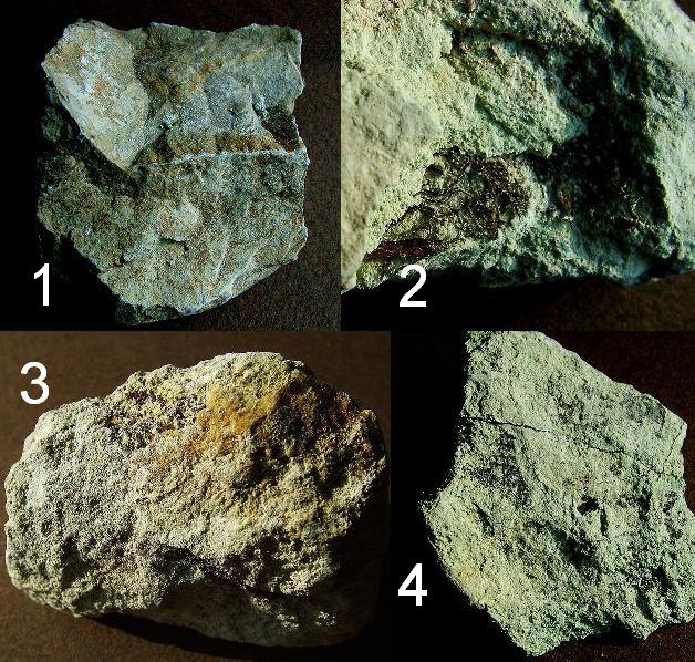
MEGYEHEGY DOLOMITE FORMATION ( 1. )
The start of Middle Triassic formation, thick-bedded layered dolomite. Contains few fossils, rare blue-green algae operation lifel from the rock surface is difficult to detect subtle banded occurs.
FELSÖÖRS LIMESTONE FORMATION ( 2. )
Brownish-gray, thin-bedded dolomarl leyer begins. The fossils are rare. (22-43th. layers). This is installed in clearer color, flint thin-bedded layered limestone. Fossils are common: cephalopods, sea lilies, worms, shellfish (No 70. Layer) of the fossils are often skeletal imprints megardt, or to pieces fell apart. International importance, known for timescale limit is 99 / c-marked surface layer - located above the front hood - 239.5 million years show. The Middle Triassic Anisian and Ladinian-floor interfaces.
VÁSZOLY FORMATION ( 3. )
Especially colored layers were found in the roof part, a protected disclosure, the colored rocks Ladin. The ocean-going operation in violent volcanoes reveal the white, green and sometimes red, volcanic dust and debris generated, with tuffit sequence of limestone and flint. The volcanic materials in seawater was mostly clay. (100-111th layers)
BUCHENSTEIN FORMATION ( 4. )
Roots of limestone, red and gray with flint. The configurations of the name comes from the Southern Alps. The volcanic material moving upward in the sequence, fewer and fewer. The layers are linked to the formation of the former submarine heights. (No. 112th. layers)
To log yor visit, please.
Send your answers via e-mail to me...
Please don’t give answers in your log !
1, Permitted to collect samples ?
2, The "d)" ammonitis Name ?
Uploaded photos with you and/or your GPS in the background with the wall are welcome.
Free Hungarian GPS unit digital map means 'hiking trail' (túristatérkép) program from here downloadable.
-----------------------------------------------------------------------
A triász tenger üledékeinek és a Föld tuzhányó muködésének több száz millió éves megkövült világával találkozhatunk sétánk során.
ÉVMILLIÓK ÜZENETE
A Forrás-hegy földtörténeti "üzeneteit" Böckh János geológus fedezte fel a XIX. század végén. Tudós kutatók munkái nyomán világszerte ismertté vált e hely. Magyarország elso földtani alapszelvényeként tartjuk számon. A Megyehegyi Dolomit Formáció képzodése idején és helyén a Tethys alig néhány méteres vízmélységével az osóceán árapály övezetébe tartozott. Katasztrofális földrengések hatására a medencefenék sok helyen megtört, megsüllyedt, ezeken a helyeken kissé mélyebb vizu lagúnák alakultak ki, melyekbe a nyílt tenger oxigénben dús vize csak korlátozottan áramlott be. Ilyen lagúnában keletkezett a dolomárga. Folytatódott a tengerfenék süllyedése, a víz mélyülése, a lagúnákból nyílt öblök lettek. Ezekben rakódott le az a mésziszap, amelybol a Felsoörsi Mészko képzodött. A nyílt tengerbol bejutottak a mélyebb vizet kedvelo, kovavázú sugárállatkák milliói is, az elhalt állatok feloldódott vázának az iszapban vándorolt anyagából képzodtek a tuzko lencsék, gumók a mészkoben.
TRIÁSZ TENGER
A Balaton-felvidék hegyeit nagyrészt a Föld történetének TRIÁSZ idoszakában, mintegy 200 - 245 millió évvel ezelott, a Tethys OSÓCEÁN medencéjében lerakódott üledékekbol megszilárdult kozetek, oslények maradványai építik fel. Az egymáshoz hasonló rétegekbol felépülo, környezetétol jellegzetesen elkülönülo kozettestet a rétegek osztályozásának tudománya (sztratigráfia = rétegtan) formációnak nevezi, s többnyire a legjobb elofordulásáról nevezi el.
MEGYEHEGYI DOLOMIT FORMÁCIÓ ( 1. )
A középso triász kezdetén képzodött, vastagpadosan rétegzett dolomit. Kevés osmaradványt tartalmaz, ritkán a kékeszöld algák életmuködésébol eredo, a kozet felszínén nehezen észlelheto finom sávozottság is elofordul.
FELSÖÖRSI MÉSZKÖ FORMÁCIO ( 2. )
Barnásszürke, vékonypados dolomárga rétegsorral kezdodik. Az osmaradványok még ritkák. (22-43. sz. rétegek). Erre települ a világosabb színezettségu, vékonypadosan rétegzett tuzköves mészko. Gyakoriak az osmaradványok: lábasfejuek, tengeri liliomok, kagylós férgek (70. sz. réteg) Az osmaradványoknak gyakran csak váz-lenyomatuk megardt meg, vagy ízeikre estek szét. Nemzetközi jelentoségu, nevezetes idojelzo határ a 99/c jelzésu réteg felszíne - feljebb található a védoteto elott -, 239,5 millió évet mutat. A középso-triász anisusi és ladin emelet határfelülete.
VÁSZOLYI FORMÁCIO ( 3. )
Különlegesen színezett rétegeket találunk a részben tetovel védett feltárásban, a színes ladin kozeteket. Az óceánban zajló heves tuzhányó-muködésrol árulkodik a fehér, zöld és néhol vörös, vulkáni porból és törmelékbol képzodött, tufitból és tuzköves mészkobol álló rétegsor. A vulkáni eredetu anyag a tengervízben nagyrészt agyaggá alakult. (100-111.sz.rétegek)
BUCHENSTEINI FORMÁCIÓ ( 4. )
Gumós mészko, sötétvörös és szürke tuzkovel. A formáció neve a Dél Alpokból származik. A vulkáni eredetu anyag, fölfelé haladva a rétegsorban, egyre kevesebb. A rétegek képzodése az egykori tengeralatti magaslatokhoz kapcsolódik. (112. sz. réteg)
A logoláshoz kérlek…
Küldd el a válaszokat számomra e-mailben...
Kérlek, ne adj meg választ a logban !
1, Megengedett-e mintát gyujteni ?
2, A "d)" ammonitisz neve ?
Ha van kedved, tölts fel fotót magadról és/vagy a GPS-edröl, a fallal a háttérben.

Additional Hints
(Decrypt)
[ ENG : ] 1, Svefg vasb gnoyr / 2, Guveq vasb gnoyr
[ HUN : ] 1, Ryfb vasb gáoyn / 2, Uneznqvx vasb gáoyn