From the guidelines, as from January 2013: "People do not need to wait for permission to log your EarthCache. Requiring someone to wait is not supported by the EarthCache guidelines. People should send their logging task answers to you, then log your EarthCache. When you review their logging task answers, if there is a problem, you should contact them to resolve it. If there is no problem, then their log simply stands."


Geomorphology is the scientific study of landforms and the processes that shape them and is practiced within geography, geology, geodesy, engineering geology, archaeology, and geotechnical engineering.
Landforms evolve in response to a combination of natural and anthropogenic processes. The landscape is built up through tectonic uplift and volcanism. Denudation occurs by erosion and mass wasting, which produces sediment that is transported and deposited elsewhere within the landscape or off the coast. Landscapes are also lowered by subsidence, either due to tectonics or physical changes in underlying sedimentary deposits. These processes are each influenced differently by climate, ecology, and human activity.
In many instances the application of geomorphology needs a wide area so that relationships between lithologies and landform masses can be compared and contrasted. However, sometimes we are lucky enough to happen upon a place where these relationships can be seen in an enclosed area and where this area can be regarded as a “working laboratory” with models of the real thing for us to play with and understand.
The coordinates for this cache take you a well known location where there are some striking buttes or models thereof where the lesson can be learned in perfect safety. Funnily enough the word "butte" comes from a French word meaning "small hill".
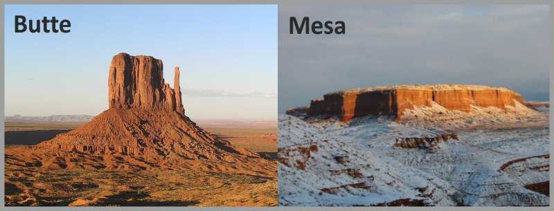
Now, buttes are conspicuous isolated hills with steep, often vertical sides and a small, relatively flat top; they are smaller than mesas, plateaus, and tables. In some regions, such as the north central and northwestern United States, the word is used for any hill. Its use is prevalent in the western United States, including the southwest, where "mesa" is also used depending on the morphology of the hill. Because of their distinctive shapes, buttes are frequently key landmarks in both plains and mountainous areas.
In differentiating mesas and buttes, geographers use the rule that a mesa has a top wider than its height, while a butte's top is narrower (see image below).
Buttes are the result of erosion processes with the added ingredients that two distinct rock types, one hard and one soft, are necessary to make the “recipe” work. Normally, the hard rock, that often forms the cap resist weathering while the softer rocks below weather more easily creating the vertical faces one sees in these rock formations.
In geology appearance is everything and when the cap rock is still in place these types of hills can be called “Hoodos”.
 A hoodo is a tall, thin spire of rock that protrudes from the bottom of an arid drainage basin or badland. Hoodoos consist of soft sedimentary rock topped by harder, less easily-eroded stone that protects each column from the elements.
They are mainly located in the desert in dry, hot areas. In common usage, the difference between hoodoos and pinnacles or spires is that hoodoos have a variable thickness often described as having a "totem pole-shaped body."
So you can see that in geology there is often a fine line between one name and another and perhaps you need voodoo to sort it out.
Therefore, in order to claim this EarthCache you need to go to the coordinates and answer the following questions:
- Given the geomorphology in front of you, do you think that the hills represented are buttes or hoodos? Justify your answer.
- How many “spikes” can you see?
- What type of rock do you think that is represented by the red-coloured rocks? (granite, limestone, mudstone, microgabbro, arenite, sandstone or syenite?)
- What type of rock do you think that is represented by the whiter coloured rock?
- Is this whiter-coloured rock located at the base of the “spikes” or the top of the “spikes”?
- What form of transport winds its way around these hills?
 If you think you have the correct answers, log your find but also send me the answers through my profile. If they're correct, your log will stand. If incorrect I will contact you. And because I like to see what you look like I would appreciate a photo of you anywhere near the hills but so that you don’t see them in the photo, although this is completely optional. Thanks for visiting.
Source:
Sprinkel, Douglas A., Chidsey, Thomas C. Jr., Anderson, Paul B. 2000. Geology of Utah's Parks and Monuments. Publishers Press: 37-59

Géomorphologie est l'étude scientifique des reliefs et les processus qui les façonnent et se pratique au sein de la géographie, la géologie, la géodésie, la géologie de l'ingénieur, l'archéologie, et de l'ingénierie géotechnique.
Géographie évoluer en réponse à une combinaison de processus naturels et anthropiques. Le paysage se construit à travers le soulèvement tectonique et le volcanisme. Dénudation se produit par l'érosion et le mouvement de masse, qui produit des sédiments qui sont transportés et déposés ailleurs dans le paysage ou au large des côtes. Les paysages sont également abaissé par les affaissements miniers, soit en raison de la tectonique ou des changements physiques dans les dépôts sédimentaires sous-jacentes. Ces processus sont tous influencés différemment par le climat, l'écologie et l'activité humaine.
Dans de nombreux cas l'application de la géomorphologie a besoin d'une vaste zone de sorte que les relations entre les lithologies et des masses de relief peuvent être comparées et contrastées. Cependant, parfois nous avons la chance de se produire sur un lieu où ces relations peuvent être vus dans une zone délimitée et où ce secteur peut être considéré comme un “laboratoire de travail" avec les modèles de la vraie chose pour nous de jouer avec et à comprendre.
Les coordonnées de cette cache vous prendre une position bien connue où il ya des buttes ou la suppression des modèles de ces pays où la leçon peut être apprise en parfaite sécurité. Curieusement le mot "butte" vient d'un mot français qui signifie "petite colline".
Maintenant, des buttes sont bien en vue collines isolées avec raides, souvent côtés verticaux et un petit, relativement plat en haut, ils sont plus petits que mesas, des plateaux et des tables. Dans certaines régions, comme les États du centre nord et nord-ouest américain, le mot est utilisé pour toute la colline. Son utilisation est très répandue dans l'ouest des États-Unis, y compris le sud-ouest, où "mesa" est également utilisé en fonction de la morphologie de la colline. En raison de leurs formes distinctives, des buttes sont des repères clés fréquemment dans les deux plaines et les régions montagneuses.
En différenciant mesas et les buttes, les géographes utilisent la règle selon laquelle une mesa a un sommet plus large que sa hauteur, tandis que le haut une butte est étroit (voir image ci-dessous).
Buttes sont le résultat des processus d'érosion avec les ingrédients a ajouté que deux types de roches distincts, l'un dur et un mou, sont nécessaires pour rendre la «recette» de travail. Normalement, le hard rock, qui fait souvent la “chapeau” résister aux intempéries tandis que les roches plus tendres ci-dessous météo plus facilement créer des faces verticales on voit dans ces formations rocheuses.
En apparence, la géologie est tout et quand le rocher de la “chapeau” est toujours en place ces types de collines peut être appelé “Hoodos".
Un hoodo est un grand clocher mince de roche qui dépasse du fond d'un bassin versant aride ou badlands. Hoodoos composé de roches sédimentaires tendres surmonté plus difficile, la pierre moins facilement érodés qui protège chaque colonne des éléments.
Ils sont principalement situés dans le désert sec, un endroit chaud. Dans l'usage courant, la différence entre les cheminées de fées et de pinacles ou flèches, c'est que hoodoos ont une épaisseur variable souvent décrite comme un "corps en forme de totem."
Donc vous pouvez voir que la géologie, il ya souvent une fine ligne entre un nom et une autre et peut-être vous avez besoin vaudou de faire le tri.
Par conséquent, afin de réclamer ce EarthCache vous devez vous rendre aux coordonnées et répondre aux questions suivantes:
1 - Compte tenu de la géomorphologie en face de vous, pensez-vous que les collines sont représentés buttes ou hoodos? Justifiez votre réponse.
2 - Combien de "pointes" vous trouvez?
3 - Quel type de roches pensez-vous qui est représenté par les roches de couleur rouge? (Granit, calcaire, de mudstone, microgabbro, arénite, de grès ou de syénite?)
4 - Quel type de roches pensez-vous qui est représentée par la couleur blanche rock?
5 - Est-ce rocher blanc de couleur située à la base des “pointes "ou le haut des “pointes”?
6 - "Quel type de transport s'enroule autour de ces collines ?"
Si vous pensez que vous avez les bonnes réponses, connectez-vous trouver, mais aussi me faire parvenir les réponses grâce à mon profil. Si elles sont correctes, votre journal sera maintenue. Si incorrecte je vous contacterai. Et parce que je voudrais voir à quoi vous ressemblez Je vous serais reconnaissant une photo de vous n'importe où près des collines, mais pour que vous ne les voyez dans la photo, bien que cette situation est totalement facultative. Merci de votre visite.
Source:
Sprinkel, Douglas A., Chidsey, Thomas C. Jr., Anderson, Paul B. 2000. Geology of Utah's Parks and Monuments. Publishers Press: 37-59

 The most exciting way to learn about the Earth and its processes is to get into the outdoors and experience it first-hand. Visiting an Earthcache is a great outdoor activity the whole family can enjoy. An Earthcache is a special place that people can visit to learn about a unique geoscience feature or aspect of our Earth. Earthcaches include a set of educational notes and the details about where to find the location (latitude and longitude). Visitors to Earthcaches can see how our planet has been shaped by geological processes, how we manage the resources and how scientists gather evidence to learn about the Earth. To find out more click HERE.