Cache Elevation: 1,700 ft
General Directions: On SR 17, 9 miles north of Soap Lake
or 10 miles south of Dry Falls Visitor's Center, turn east onto
short access road to Lake Lenore Caves within the Lake Lenore State
Wildlife Management Area. Follow well-marked trail to Lake Lenore
Caves and beyond.
See
You Tube for video footage taken from the Great Blade by Tom
Foster (hugefloods.com).
Great Blade Notch
"...there were a few double falls each member of which
receded at approximately the same rate, so that the island in
mid-channel became very much elongated, like a great blade,
as the falls receded and the canyons lengthened." J Harlen Bretz
(1928)
A tall, narrow basalt ridge, coined "The Great Blade" by J
Harlen Bretz, parallels Lower Grand Coulee east of Lake Lenore
(Figure 1). The blade is the product of Ice Age floods that
repeatedly rampaged Grand Coulee as recently as 15,000 years ago.
Most of the floods appear to have come from sudden outbursts from
glacial Lake Missoula. During flooding the coulees on either side
of the Great Blade were filled with up to 800 ft turbid water. The
largest floods also overtopped the Great Blade, submerging the
Earthcache site under at least another 100 ft of floodwater.
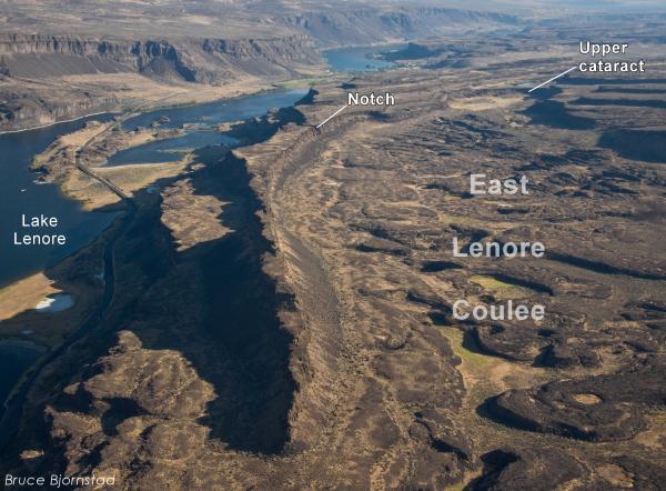
Figure 1. Like a giant snake the Great Blade
winds through Lower Grand Coulee. The rock blade divides Lake
Lenore (left) from East Lenore Coulee on the right. The Earthcache
is located at a distinct notch along the Great Blade. Looking
north.
On the west side of the blade, where Lake Lenore
is located, lies the Lower Grand Coulee, which ultimately migrated
10 miles northward - all the way to Dry Falls. On the east side of
the blade is the higher East Lenore Coulee, which migrated a
shorter distance (~3 mi) to Dry Coulee (Figures 2 and
3).
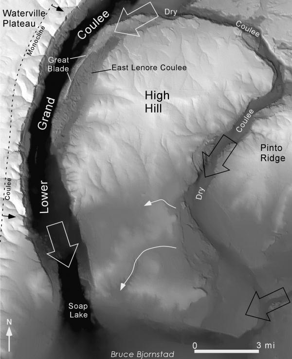
Figure 2. Shaded-relief map showing the coulee
system that developed within Lower Grand Coulee and places east.
The Great Blade was formed by the simultaneous recession of two
cataract canyons, one along the Lower Grand Coulee and the other
within East Lenore Coulee. The recession of East Lenore Coulee
stopped just before breaching the divide into Dry Coulee. During
Ice Age flooding the entire area was submerged except the
Waterville Plateau and the tops of High Hill and Pinto Ridge. Block
arrows indicate primary flood-flow direction.
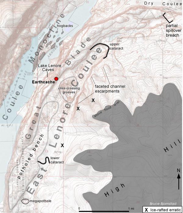
Figure 3. Topographic map of the Great Blade
and surroundings. Hogback islands in Lake Lenore are flood-ravaged
remnants of tilted basalt along the Coulee
Monocline.
Like a gigantic rib the Great Blade is tallest
and narrowest at its south end, widening to the north. The blade
extends for almost four miles from where the head of East Lenore
Coulee intersects Dry Coulee. In places the blade narrows to as
little as 800 ft wide (Figures 3 and 4).
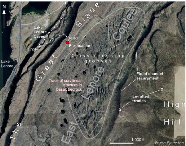
Figure 4. Aerial photo showing criss-crossing,
giant grooves and potholes of East Lenore Coulee. The grooves and
potholes were eroded into the top of the Grande Ronde basalt by
powerful flood currents moving through this area. Dashed white line
indicates trail to Earthcache. Block arrows indicate primary
flood-flow directions.
Just east of Lake Lenore and The Great Blade is a
5.3-mile-long hanging coulee referred to here as East Lenore Coulee
(Figures 2-4). Bretz called this now completely dry coulee "the
synclinal valley". A two-tiered recessional cataract canyon, it may
have started out as a stream valley that followed the trough of a
geologic syncline (downwarped trough). Later, Ice Age floods
naturally followed this ancient valley carving scabland along its
reach. However, the enormous volume of floodwater descending
through the area simultaneously flowed along the edge of the Coulee
Monocline to the west. Bent layers of basalt were more broken along
the tilted monocline making the rock easier to erode. Thus, the
Lake Lenore channel was deepened faster than in the East Lenore
Coulee. In this way the dominant flood channel eventually shifted
west into its present position (Lower Grand Coulee) by carving more
into the folded, more broken rocks of the monocline. Today ancient
hanging valleys, perched high above the west wall of the coulee
attest to the deep scouring that occurred during multiple Ice Age
floods within the Lower Grand Coulee (see Figure 7).
East Lenore Coulee is bounded on the west by the
Great Blade and on the east by High Hill, where several faceted
escarpments were eroded along the up-to-¾-mile-wide channel
(Figures 3 and 4). Like stairsteps, two basalt tiers and cataracts
occur, one each in the upper and lower ends of the coulee. The head
of East Lenore Coulee ends at the divide crossing with Dry Coulee
(Figure 3). During the last, or one of the last, Ice Age floods
spillover into East Lenore Coulee began to breach the divide with
Dry Coulee. This is apparent from the hanging channel at the head
of the coulee that today is perched high above the floor of Dry
Coulee (Figure 3).
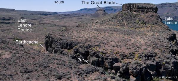
Figure 5. A giant rib of eroded basalt, the
Great Blade, separates Lake Lenore and Lower Grand Coulee on the
right from East Lenore Coulee on the left. Earthcache is located at
left (east) end of narrow notch in the Great Blade, visible in the
foreground.
An elevated, rock bench of Grande Ronde basalt
lies along either side of the lower East Lenore Coulee. The rock
bench is pockmarked with dozens of circular, deep potholes (Figures
1 and 4). Another interesting feature is a group of giant,
intersecting grooves that lies midway within the East Lenore Coulee
(Figures 4 and 6). The grooves criss cross each other, intersecting
at oblique angles. One direction generally aligns with the
flood-flow direction; grooves going in other directions appear to
reflect erosion along curvilinear cracks (fractures) within the
basalt. These curving fractures may be large-scale cooling features
that formed as the basalt solidified from molten lava, or perhaps
are related to more-regional tectonic forces applied to the basalt
after the lava cooled. Ice age floodwaters rushing over these
fractures etched out the weaker and more easily eroded rock along
the fracture planes.The deep notch in the Great Blade where this
Earthcache is located lies along one of these flood-etched
curvilinear features (Figure 4).
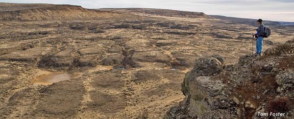
Figure 6. Criss-crossing grooves in East
Lenore Coulee viewed from the Great Blade.
From the Earthcache (Figure 7), at the east side
of the Great Blade notch is a breathtaking view into East Lenore
Coulee. The Earthcache lies at an elevation of ~1,700 ft, one
hundred feet or more below the height of the largest floods. The
Great Blade and access to the notch is owned and managed by Sun
Lakes State Park. The best way to access the notch and Earthcache
are to hike past the Lake Lenore Caves, then circle back to the
north after reaching the giant, overhanging pothole (N47deg
30.738min, W119 deg 29.880min) , and rock bench above the caves.
From N47deg 30.818min, W119 deg 29.633min is a moderately steep,
300-ft scramble up to the Great Blade notch. The Earthcache is
located at viewpoint at the far southeast end of the notch (Figure
5).
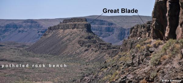
Figure 7. View from Earthcache. At eye level
are eroded remnants of the volcanic, 15-million-year-old columnar
basalt of the Roza Member, capped by the Priest Rapids
Member– the youngest basalt flow in this region. During the
largest floods even the top of the Blade was completely awash in
floodwaters. Several hanging valleys are visible in the background;
these were carved out by ancient streams draining off the west side
of the Coulee Monocline, which was later removed by Ice Age floods,
leaving the tributary valleys high and dry. Looking
southwest.
To receive credit for finding this Earthcache
answer the following question: "How many hanging valleys are
visible along the west wall of Grand Coulee from the Earthcache
site?" Email the answer to bjorn99352@yahoo.com.