Bodenlehrpfad "Kalchreuth-Wolfsfelden"

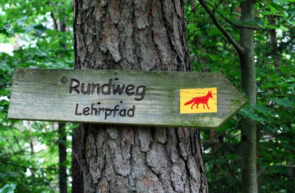
Der Bodenlehrpfad hat eine Länge von 1,5 km und das Zeichen mit dem Fuchs
und befindet sich in der Nähe von Kalchreuth, das bekannt für seine guten Kirschen ist.
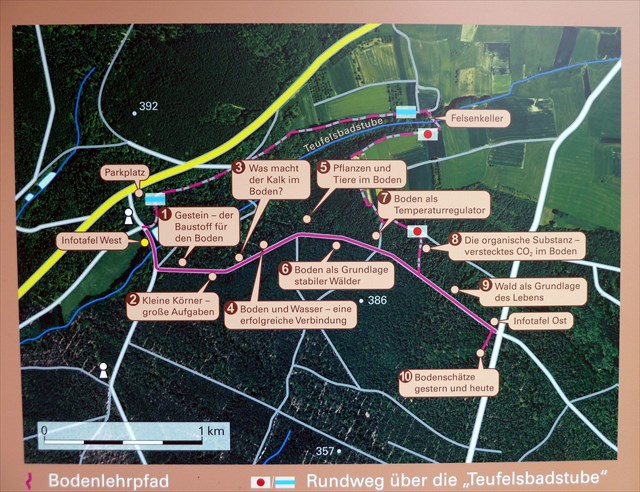
Ihr findet an 10 Stationen mit Schautafeln interessante Informationen über den Aufbau und die Eigenschaften der Böden.
Es werden bodenkundliche und geologische Gegebenheiten erklärt, aber auch alte Steinbrüche und Tongruben sind in den Lehrpfad integriert.
Anhand von Bodenprofilen erhält man einen Eindruck der ganz unterschiedlichen Waldböden.
Erdgeschichtlich führt der Lehrpfad von der Phase des Keupers bis hin zum Jura.
Wie entstand diese Vielfalt an Bodenformen , wie wir sie in der Region haben?
Das germanische Becken, eine große Senke, bildete sich Anfang des Erdmittelalters.
Das Meer drang immer wieder in dieses Becken ein und zog sich wieder zurück.
So entwickelten sich langsam fließende Flüsse und flache Seen.
Starke Verdunstung und eine leichte Hebung und Senkung der Landschaft führten zu einem ständigen Wechsel von Sand, Ton und Kalkablagerung.
Im Zeitalter des Keupers kamen diese unterschiedlichen geologischen Schichten an die Oberfläche und bewirkten so diese Bodenvielfalt.
Wegbeschreibung
Auf der Kreistrasse ERH 6 ist der Parkplatz "Bodenlehrpfad" ausgeschildert.
Koordinaten : N 49.32.807 E 011.06. 288.
Von dort führt ein Forstweg zum Beginn des Lehrpfades.
Er führt durch die vielfältige Landschaft des nahe gelegenen Ortes Kalchreuth. Den Rückweg kann man auch über den Wanderweg Rotpunkt und später beim Felsenkeller Blaustrich machen. Dieser Weg ist der Schönere
In der Nähe befindet sich auch, in der bewaldeten Rhätschlucht "Teufelsbadstube", der schöne schattige Biergarten "Felsenkeller", wo man sich noch erholen kann.
Aufgaben
1.Wie heißt das rote Tongestein und welche 2 Farben hat dort der Boden?
2.Was sieht man bei WP1 auf der Tafel abgebildet?
3.Was sieht man bei Station 7 und welche Höhe hat es?
4.Welche Höhe hat der Boden bei WP2
5.Was sieht man am Schluss und wie heißt hier das Bodenmaterial
Bei den Fragen mit den Höhen möcht ich die sichtbare Höhe des Gegenstandes, keine Höhenangabe über das gps.
Sendet eure Antworten an den GC Account und loggt gleich, ich melde mich, wenn etwas nicht passt.ich akzeptiere Logs nur noch bei gleichzeitigen Antworten auf die Fragen und zeitnah.Logs, die nicht zeitnah mit den Antworten sind werden gelöscht. Jeder der loggt, sendet bitte auch Antworten, sonst wird der log auch gelöscht.
Es wäre schön, wenn ihr noch bei irgendeiner Station ein Foto machen würdet.
Viel Spaß beim Bestaunen der unterschiedlichen Böden
.
Ground-Nature trail "Kalchreuth-Wolfsfelden"
The ground -nature trail is a walk from approx. 1.5-km length with the sign red fox and is near by Kalchreuth , which is famously for its good cherries.
You will find 8 stations with diagrammes and interesting information about the construction and the qualities of the grounds.
Pedological and geologic circumstances are explained, but also old stone quarries and sound pits are integrated into nature trail.
On the basis of ground profiles one receives an impression of the quite different forest grounds.
Geological the ground - nature trail leads from the phase of the Keupers up to the Jura.
How did this variety of grounds arise, like we have them in the region?
The Germanic basin, a big depression, formed the beginning of the earth Middle Ages.
The sea penetrated over and over again into this basin and go back again.
Due to that fluent rivers and level lakes developed slowly.
Strong vaporisation and a light elevation and lowering of the landscape led to a constant change of sand, tone and lime deposition.
In the age of the Keupers these different geologic layers came to the surface and caused this ground variety.
Route description
On Kreistrasse ERH 6 the parking bay "Bodenlehrpfad" is signposted.
Co-ordinates: N 49.32.807 E 011.06. 288.
From there a forest way leads to the beginning of the nature trail. It leads through the landscape of the near village Kalchreuth.
Nearby is also the wooded Rhätgorge "Teufelsbadstube" with the nice shady beer garden "Felsenkeller", where you can recover.
Log Conditions
1.The name of the red Clay and the 2 colours of the ground
2.what do you see on WP1 on the board ?
3.What do you see on station 7 and the height of it ?
4. The height of the ground on WP2
5. What do you see at the end and the name of the ground material ?
You con log.If something is wrong, I will contact you.
It would be nice if you could take a photo at any station.
A lot of fun while marvelling at the different grounds.