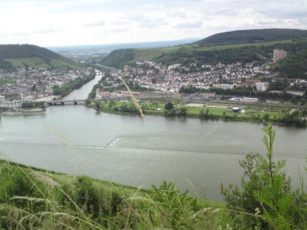
Die Nahemündung am "Binger Loch"
Die Täler der Nahe und ihrer Nebenbäche formten sich in geologisch junger Zeit infolge einer Hebung der Erdoberfläche. Die Gewässer erhielten dadurch ein stärkeres Gefälle. Vor allem in Schmelzperioden während der Eiszeiten, als hier Tundrenklima herrschte und der Boden nicht durch eine dichte Vegetation geschützt war, kam es zu starker Erosion durch die reißende Strömung der Bäche und Flüsse. Je nachdem, wie hart der Gesteinsuntergrund war, entstanden dabei enge Täler mit schroffen Felshängen oder weiträumige, sanft geformte Täler. Im Nahegebiet ist der häufige Wechsel zwischen beiden reizvoll.
Enge und felsige Talabschnitte finden sich da, wo harte vulkanische Gesteine anstehen, weiträumige im Bereich weicherer Sedimentgesteine. Überwiegend gehören die Gesteine der geologischen Epoche des Rotliegend am Ende des Erdaltertums an. Damals herrschte im Bereich des Nahegebietes ein lebhafter Vulkanismus. Das rötliche Vulkangestein Rhyolith verwittert in den höher gelegenen, niederschlagsreicheren Teilen des Nahegebietes zu relativ saurem Boden. Dort ist die typische Flora nur schwach vertreten.
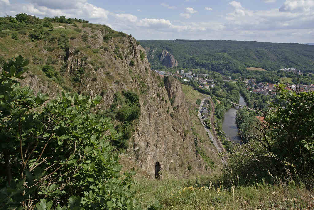
In der Gegend um Bad Kreuznach und Bad Münster am Stein jedoch herrscht im Regenschatten des Hunsrücks warmes und recht trockenes Klima. Dort liefert der Rhyolith bei der Verwitterung neutrale bis basische Böden, auf denen sich geradezu ein „Hot Spot“ botanischen Artenreichtums entwickelt hat. Dieser beruht auch darauf, dass sich die Nahe dort durch ein mächtiges Rhyolithmassiv genagt und dabei grandiose Felshänge geschaffen hat, darunter den berühmten Rotenfels, der fast 120 m hoch nahezu senkrecht aufragt und die höchste Felswand Deutschlands außerhalb der Alpen ist. Er präsentiert sich als riesiger Natur-Steingarten.
Pflanzen wie Bleicher Schwingel (Festuca pallens), Felsen-Gelbstern (Gagea bohemica subsp. saxatilis), Blaugrünes Labkraut (Galium glaucum), Steppen-Spitzkiel (Oxytropis pilosa), Großes Federgras (Stipa pulcherrima) und Roßschweif-Federgras (Stipa tirsa, sind in einer nacheiszeitlichen Wärmeperiode nach Europa eingewandert. Als danach das Klima erheblich kühler und feuchter wurde, starben sie im größten Teil Deutschlands wieder aus und überlebten nur an Stellen, wo aufgrund besonderer geographischer Gegebenheiten kleinräumig weiterhin die Wärme und die Trockenheit herrschten, an die sie angepasst sind.
Im Nahetal und seinen Seitentälern sind dies besonders Felshänge, die nach Süden oder Südwesten gerichtet sind und auf welche im Sommer die Sonnenstrahlen in steilem Winkel auftreffen. An heißen Sommertagen entwickeln sich dort wahrlich steppenhafte Verhältnisse mit Bodentemperaturen von 60° oder mehr. Aber nicht nur Felsen, sondern auch Laubwälder und Gebüsche, welche weniger felsige Steilhänge bedecken, weisen ein ziemlich warmes und trockenes Lokalklima auf und sind geeignete Lebensräume für wärmeliebende und trockenheitsertragende Pflanzen, deren Gesamtheit man als Xerothermvegetation bezeichnet.
Bei Bingen mündet die Nahe in den Rhein, genau an der Stelle, die weitläufig das "Binger Loch" genannt wird.
Nun zum Cache
Die Lösung der Aufgaben sind zum Teil auf dem Gelände des „Park am Mäuseturm“, der entlang der Nahe bzw. des Rheins frei zugänglich ist, zu finden. Geöffnet ist der Park im Sommer ab 6 Uhr, im Winter ab 8 Uhr, jeweils bis Einbruch der Dunkelheit. Der Eintritt ist frei.
Um diesen Cache loggen zu können, erfüllt bzw. löst folgende Aufgaben:
1. Bitte macht ein Foto von Euch bzw. Eurem GPS am Waypoint "Fotopunkt" und hängt dieses Eurem Log an.
2. Schätzt die Breite der Nahemündung parallel zur Eisenbahnbrücke.
3. Welche Jahreszahl ist an der Eingangsseite des „Historisches Museum am Strom“ eingemeißelt?
4. Zu was regen die vier Grundelemente Feuer, Luft, Wasser und Erde an?
5. Wie ist der Name eines der ältesten topographisch exakt identifizierbaren Motives der Landschaftsmalerei?
Die Antworten schickt mir bitte über die e-mail-Adresse in meinem Profil. Ihr braucht meine Logerlaubnis nicht abzuwarten und könnt direkt loggen. Sollte es große Abweichungen geben, melde ich mich bei Euch.
Nun viel Spaß beim Tüfteln und Ermitteln
English description
The Stuary of the Nahe-River at the "Hole of Bingen"
The Nahe-Valleys and her tributary streams were formed in geologically young time as a result of an elevation of the earth surface. It came, above all, to glaze periods during the ice ages when tundra climate here ruled and the ground was not protected by a thick vegetation to strong erosion by the tearing current of the brooks and rivers. Depending on how hard the rock subsoil was, besides, narrow valleys with gruff rock slopes or ample, softly formed valleys originated.
Narrow and rocky valley segments are found where hard volcanic rocks queue, ample sediment rocks softer in the area. Predominantly the rocks of the geologic epoch belong "Rotliegend" at the end of the earth antiquity. At that time a lively volcanism ruled in the area. The reddish volcano rock "Rhyolith" weathers in the higher situated parts richer in precipitation of the close area to relatively sour ground. There the typical flora is only weakly represented.
Nevertheless, in the area around Bad Kreuznach and Bad Münster in the stone warm and rather dry climate rules in the rain shade of the Hunsrück. There delivers of the Rhyolith with the decomposition neutral to calcicolous soil on which has developed almost „Hot Spot“ of botanical rich animal and plant life. This is also based on the fact that has gnawed itself close to there by a mighty Rhyolithmassiv and, besides, has created magnificent rock slopes, under it the famous red rock which rises nearly 120 m high nearly vertically and is the highest rock wall of Germany beyond the Alps. It presents himself as a gigantic nature-stone garden.
Plants like Pale Schwingel (Festuca pallens), Rock-Yellow Star (Gagea bohemica subsp. saxatilis), Blue Green bedstraw (Galium glaucum), Steppen-Spitzkiel (Oxytropis pilosa), Big Feather Grass (Stipa pulcherrima) and Horse Tail Feather Grass (Stipa tirsa) have immigrated in a glacial warm period to Europe.
When afterwards the climate get considerably chiller and more humid, they get extinct in the biggest part of Germany again and survived only at places where special geographic circumstances small-scale furthermore the warmth and the dryness ruled in which they are adapted. In the close valley and his side valleys are this especially rock slopes which are directed after the south or southwest and on which in summer the sunrays in precipitous corner strike. During hot summer days steppes-like relations with ground temperatures of 60 ° are developed there. Not only rocks, but also deciduous forests and bushes which less rock cover show a quite warm and dry local climate and are suitable living spaces for warm-loving and dryness-enduring plants whose totality called Xerothermvegetation.
Near Bingen the Nahe-River flows into the Rhine-River, exactly here people call it "The hole of Bingen".
Now to the Cache
The solutions of the questions are to be found partly on the area of the „park at the mouse tower“. The park is opened in summer from 6 o'clock, in winter from 8 o'clock, in each case to nightfall. The entry is free.
Please answer the following questions and send me the answers to my profile. You can log this cache directly to the mail. If there is something wrong, I will contact you.
1. Please take a photo of you or your GPS at the waypoint "Fotopunkt" and attach this Picture to your log.
2. Estimates the wide of the estuary of the River Nahe parallel to the railway bridge.
3. Which annual number is chiseled on the Frontside of the „Historical Museum of the Stream“?
3. The basic elements fire, air, water and earth animate you to .... ?
4. How is the name of one of the oldest topographically exactly identificable motives of the landscape painting?
And now have fun.