Ein echter Drive-Thru Earthcache
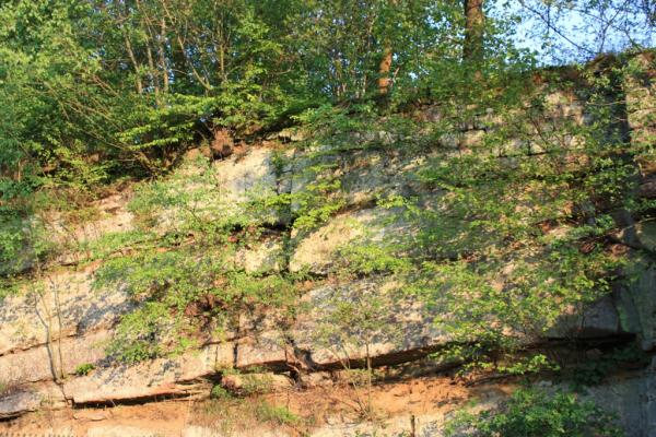
Am Rondell der Bushaltestelle in Hardehausen befindet sich auf einer Länge von
20 Metern eine hohe, senkrechte Wand des Sollingsandsteins (Wilhelmshauser Schichten), aufgeschlossen mit Schrägschichtungssets.
Diese Buntsandsteinwand setzt sich als steile Böschung mit Einzelaufschlüssen auf ca. 0,82 ha noch rund 40 m nach Südosten fort.
Die Felsen stammen aus dem System Trias des Mesozoikum und sind damit
ca. 200- 250 Millionen Jahre alt.
Diese Wand ist als hervorragendes Landschaftselement als Naturdenkmal und Geotop eingestuft.
Um diesen Cache zu loggen, müsst Du folgende Fragen beantworten:
-
In welche Abschnitte wird das Mesozoikum unterteilt?
-
Welche Gesteinseinheiten lassen sich noch dem Trias zuordnen?
-
Wie hoch ist die geschätzte Höhe der Sollingsandsteinwand?
Nachdem Du uns die Antworten zugemailt hast, kannst Du sofort loggen, wenn etwas nicht stimmt werden wir uns melden. Optional kannst Du dem Log noch ein Foto von Dir und/oder Deinem GPS vor der Sandsteinwand beifügen, was uns natürlich freuen würde.
Viel Spaß wünschen 
A real Drive-Thru Earthcache
At the rondell of the bus stop in Hardehausen is on a length of 20 meters a high, vertical wall of the Solling sandstone (Wilhelmshauser layers), open with sloping stratification sets.
This coloured sandstone wall continues itself as a scarp with single explanations on approx. 0.82 ha still about 40 m after southeast away.
The rocks come from the system Triassic of the Mesozoic and are approx. 200-250 million years old with it.
This wall is classified as an excellent scenery element as a natural monument and geotop.
The logging requirements are as follows:
Post with your log a photo showing you or your GPSr in front of the wall and e-mail us the answers to the following questions:
1. Into which segments is the Mesozoic divided?
2. Which rock unities can be still assigned to the Triassic?
3. What is the rated altitude of the Solling sandstone wall?
You can log this cache right away after you have mailed us the answers. If something ist wrong we will contact you. You can optionally add with the log a photo of you and/or your GPSr in front of the solling sandstone wall.About photos we would be pleased.
Have fun