Landslide! EarthCache
-
Difficulty:
-

-
Terrain:
-

Size:  (not chosen)
Please note Use of geocaching.com services is subject to the terms and conditions
in our disclaimer.
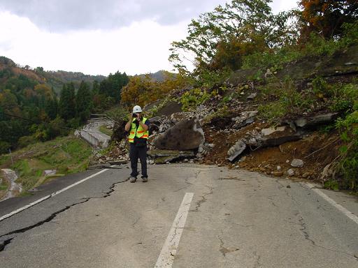
On this site, on April 17th, 1991 a huge amount of earth gave way
to a landslide burring a large section Brimley Road below Kingston
Road in Toronto. The debris slid from the west side of the valley
all the way across to the east. This landslide shutdown access to
the base of Brimley Road stranding tourists and permanent
residents.They landslide was attributed to the amount of rain
received over the previous days. The cleanup effort took weeks and
there are still many signs that this landslide took place.
Several common causes of landslides are:
* Water: Perhaps the most common trigger of a landslide, water
reduces the friction between the bedrock and the overlying
sediment, and gravity sends the debris sliding downhill. In sand
and clay soils, a small amount of water may increase stability.
You've likely seen this when building a sand castle or working with
clay. However, too much water causes the sediment to flow, which is
why many landslides occur after rainstorms.
*Earthquakes: If the Earth's crust vibrates enough to disrupt the
force of friction holding sediments in place on an incline, a
landslide can strike.
* Wildfires: Plants help to stabilize the soil by holding it
together like glue with their roots. When this glue is removed, the
soil loosens, and gravity acts upon it much more easily. The loss
of vegetation after a fire makes the razed land susceptible to
slides.
* Volcanoes: Several characteristics of volcanoes make them a
fertile starting point for especially destructive landslides. On
the next page, you'll learn just how powerful these volcanic
landslides can be.
To log this
cache:
Posted coords put you on a stretch of road that was built as a
temporary bypass for construction vehicles during the cleanup from
the landslide. This road was built on the top of the debris and has
been left in place as a walkway for pedestrians. In order to
officially log this cache you must email me the following
information:
1) Navigate to N 43° 42.564 W 079° 14.286 and record your
altitude above sea level.
2) Navigate to N 43° 42.565 W 079° 14.306 (Depth Reference)
and record your altitude above sea level.
3) Using the above calculate the depth of the debris left from this
landslide
4) Starting from the north of the temporary road walk the entire
path and with the use of your GPS record the length of the path.
This will give you an width of the chunk of earth that broke loose.
Email me the number.
5) Observe your surrounding and give me two(2) examples of the
surrounding area that would lead you to believe that was a
landslide on this site.
6) As a bonus, please post a picture of you and your GPS at the
cache site <- Note: this is NOT mandatory.... Just fun!
Additional Hints
(No hints available.)