Martorpsfallet Earthcache
| I would be very thankful if you could write you email and
log in English. Nevertheless also Swedish email/logs are
welcome. |
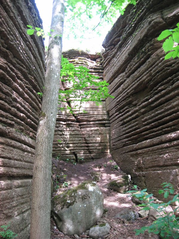
This earthcache would like to bring you to the Martorp
waterfall in the Kinnekulle nature reserve. At the above
coordinates you will stand above the waterfall and find an
information board about it. You get the best view on the waterfall
and its rock formations if you walk down the cleft and watch
everything from beneath. The amount of water is at its highest
level during springtime and the water gushes down the limestone
cleft. The fall can be completely dried out during dry summer
months and then the drainage mainly goes on underground through
cracks in the bedrock.
Click for enlargement
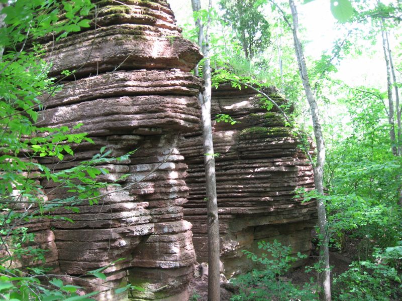
About 9000 years ago when the inland ice was melting the sea
reached this level for some time. The waves hollowed out caves
where the limestone was softer. Formations of harder material
remained. These remind us of similar formations (raukar) that can
be seen on Öland and Gotland. The limestone bed is full of
orthoceratites and other petrified animals (fossils) that lived in
the sea millions of years ago.
Limestone in general is a sedimentary rock composed largely of the
mineral calcite. Like most other sedimentary rocks, limestones are
composed of grains; however, most grains in limestone grains are
skeletal fragments of marine organisms such as coral or
foraminifera. Other carbonate grains comprising limestones are
ooids, peloids, intraclasts, and extraclasts. Some limestones do
not consist of grains at all and are formed completely by the
chemical precipitation of calcite or aragonite. i.e.
travertine.
The solubility of limestone in water and weak acid solutions leads
to karst landscapes. Regions overlying limestone bedrock tend to
have fewer visible groundwater sources (ponds and streams), as
surface water easily drains downward through joints in the
limestone. While draining, water and organic acid from the soil
slowly (over thousands or millions of years) enlarges these cracks;
dissolving the calcium-carbonate and carrying it away in solution.
Most cave systems are through limestone bedrock.

Click for enlargement
The path to the waterfall crosses overgrown pastureland. Today
there is a forest with many different kinds of bushes and trees.
The Early Purple Orchid that grows in soil rich in lime can be
found in small glades in the forest. There are mainly big elms that
grow in the limestone cleft at the waterfall. If you are fortunate
you may possibly see a dipper in the gushing water.
Old maps tell there was a mill close to Martorpsfallen already when
Carl von Linné travelled in Västergötland in 1746. Remains of the
pond and the walls of the mill can be seen just above the cleft. A
lot of cottages and crofts were built during the 19th century
alongside the cleft at Martorp. Today there are only a few
overgrown remains left.
Click for enlargement
To
log this earthcache, perform the following
tasks:
- Describe the amount of water in the waterfall during your
visit.
- Determine the average height of the limestone layers of the
waterfall.
- Optional: take a photo of you or your GPS
in front of the waterfall.