Drake's Landing EarthCache
geodarts: With the role of Drake being re-examined to rename the boulevard and other tributes, this needs to be rethought.
-
Difficulty:
-

-
Terrain:
-

Size:  (other)
Please note Use of geocaching.com services is subject to the terms and conditions
in our disclaimer.
In 1579, Francis Drake took a break from raiding the Spanish and landed at "New Albion" to repair the Golden Hind before heading westward across the Pacific. The site was named for cliffs that reminded him of those in Dover. Many believe that these are the same cliffs seen today at Drake's Bay on the Point Reyes Peninsula.
 Drake may or may not have have come here, but the geology of the area reveals many tales. This cache starts at an interpretative sign describing the cliffs and takes you along the beach to a monument that was placed to honor of Drake's landing (N 38° 02.078 W 122° 56.433). You will not find a traditional cache container; instead you are invited to learn more about the geology of the area and to log your visit after completing the requirements below.
Visiting the Monument is part of this cache but please respect the nature of the area: stay away from cliffs (falling rocks), watch the tide, and do not disturb the wildlife. Seals should be given a 300 feet berth. They are very sensitive and vulnerable to disturbance. Do not approach a seal under any circumstances.
The Purisma Formation
The cliffs along the beach are part of the Purisma (formerly called Drake's) Formation. It is a young formation, about a million years old. Originally, it was thought to be unique to the area, but it was found to be similar to rocks in the Santa Cruz Mountains, indicating that it was formed before the Peninsula started to move north along the San Gregorio and San Andreas faults.
The formation is made up of siltstone, claystone, and fine grained sandstone. It is the last of the marine deposits that were laid upon the granite base that is prevalent in the region.
As you walk along the beach, notice the horizontal layering showing the successive deposits. The cliffs display prominent faults (fractures in the earth's crust) that were formed in response to uplift and the move of the land north. You can also see many interesting weathering features, including iron staining and color banding.
The intricate tile-like patterns in the bedding plane are particularly striking. The rims are distinct from the interior, forming "a prime example of a dewatering structure" that resists erosion far better than the cliffs.
Coastal Equilibrium
Coastal cliffs forms where wave erosion steepens an elevated coastline. This leads to rock falls and slides, which cause the cliff to retreat from the ocean.
A coastal area is shaped by various kinds of processes that change its system. Steady state equilibrium describes short term variations along the coast, such as the daily rhythm of waves that push sand to shore, maintaining the width of a beach. Meta-stable equilibrium is a dramatic alteration associated with a major storm or tsunami event. Such powerful occurrences can relocate large volumes of sediment or destroy ocean cliffs. Dynamic equilibrium is the gradual but constant change in the system over a period of many years, such as the rising of an ocean level or shoreline retreat due to climate changes.
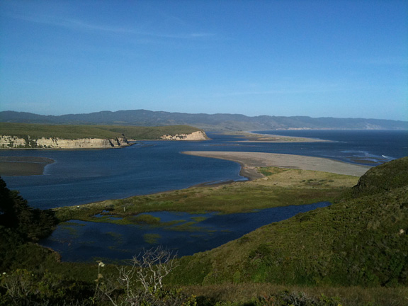
Drake's Estero
Your walk will end at Drake's Estero, which is a beautiful reminder of how the earth changes through time. The estero is a drowned river valley that was cut into the Peninsula by rivers that flowed off the Inverness Ridge during the ice age, when the ocean was 400 feet lower than it is today. As glaciers melted, the sea level rose and the valleys were flooded.
The Estero is constantly changing. Several years ago, one of the proponents of the Drake landing site correctly predicted that a spit of land would reappear in the cove which had disappeared 53 years before. The spit closely resembled that which was shown on a map made after Drake's expedition.
The estero used to be navigable by small ships that went up to Schooner Bay to take the area's dairy products to the foot of Market Street in San Francisco. Presumably, Drake was able to sail his ships here. Your walk will end at the monument a short ways up the estero.
Logging Requirements
Please email me through my profile rather than use the message center.
Answer the following questions after identifying the name of this earthcache:
- How do you think the various kinds of equilibrium contributed to this area? Does the equilibrium change as you hear the estero?
- Does wave action undercut the cliffs until they collapse and the area returns to equilibrium or does the equilibrium smooth the transition of the area, protecting the cliffs so that they gradually weather and erode from other causes? What appears to be the cause of erosion along the cliffs?
- In 1954, the British government donated an anchor that was placed at the location believed to be the landing site. (See additional waypoint.) What conditions might have made this a likely spot for Drake to have landed and repaired his ship? What kinds of geological factors do you observe at the estero that might affect whether a ship could land at the Estero - could a ship land there at the time of your visit?
- Photo Requirement: Take a picture of the anchor marking the landing site. If you cannot get to the anchor without passing within 300 feet of a harbor seal, take a picture at the location marking the end of your hike. In keeping with the June 2019 guidelines, the picture does not have to include yourself, but it should otherwise show your gpsr or a personal item identifying you.
You do not have to wait for approval to log your find, but please submit your answers before doing so. Logs that have not fulfilled the logging requirements will be deleted.
Important Information
The walk out to the monument is a little more than a mile, along the beach and over some of the bedding rocks. The rocks just before the first cove may be a little tricky, particularly with the tides. My family has never had any problems crossing them, but be careful and do not climb down from the bedding unless you are comfortable.
We have always enjoyed this as a family-friendly walk along the beach. But the area can change depending on the weather and the tides. Stay away from the cliffs so that nothing falls on you as a result of erosion. Be aware of how the tides might change during your walk. The walk should be done at low tide. High tides could make your return much more difficult. Check a tidal chart before you come to the area. If the visitor center is open, you can ask the rangers for more information about walking to the monument.
Drake's Estero is a wilderness. We have seen falcons flying over the cliffs and enjoyed its rugged beauty. But please do not approach any animals you encounter. The NPS asks that visitors stay at least 300 feet away from seals.
Make sure that you "leave no trace" and return with everything that you brought along with you.
There was a trail that still appears on many maps taking people from the first cove to the monument area. This trail has been permanently closed by park officials.
Sources
In addition, the Drake's Beach Visitor's Center offers information about Drake's voyage. A wikipedia article explores different theories about where Drake might have landed.
Additional Hints
(Decrypt)
ng gur raq, ybbx sbe gur ovt cbfg