English description
below
 Deutsch:
Das
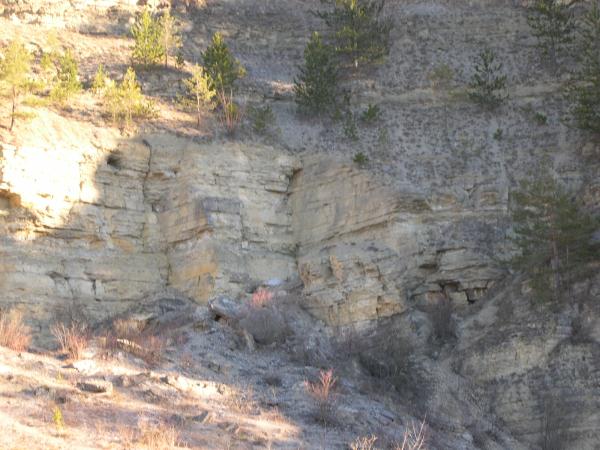
Jonastal
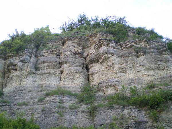
Das etwa 15 Kilometer lange Jonastal
ist ein Geländeeinschnitt, der sich von Crawinkel nach Arnstadt im
zentralen Thüringen zieht. Es beginnt als flach ausgeprägtes
Tal und verläuft in nordwestlicher Richtung. Dabei
durchschneidet es als typisches Karsttrockental die Ohrdrufer
Muschelkalkplatte zwischen dem Plateau von Gossel und der
Bittstädter Hochplatte. Es wurde im Wesentlichen durch die
Erosionswirkung der wilden Weiße bereits während der Eiszeit
gestaltet. Während der nachfolgenden Jahrtausende haben exogene
Naturkräfte weiter die Gestalt des Tales verändert. Besonders
fallen hierbei der Bienstein, der Wüste Berg und der Jungfernsprung
auf. Die Verkarstung des Tales wird neben der Versickerung der
Niederschläge auch durch die Entstehung mehrerer Kleinhöhlen
(Böhlersloch, Untere und Obere Biensteinhöhle) dokumentiert. Die 30
Meter hohe Felswand des Jungfernsprungs zeigt hier besonders
eindrucksvoll die erosive Wirkung der wilden Weiße, die diesen
Prallhang aus der Bittstädter Muschelkalkhochfläche
herausgearbeitet hat. Heute führt das Flussbett nur bei Starkregen
oder bei rascher Schneeschmelze Wasser. Ansonsten versinkt das
wenige Wasser im Muschelkalkkarst und fließt unterirdisch, bis es
am südlichen Stadtrand von Arnstadt wieder ans Tagelicht tritt. Die
topografischen Höhen liegen im Talgrund bei 410m über NN (Westteil)
und 310m über NN (Stadtrand von Arnstadt).
Bekannt ist das Tal weiterhin durch
ein geheimes Bauvorhaben in diesem Gebiet zur Zeit des
Nationalsozialismus.
Die Fragen:
Um diesen Cache zu loggen, mache bitte ein Foto von Dir mit Deinem
GPS bei den Listingkoordinaten wie auf dem Beispielfoto zu sehen.
Ferner sende mir eine E-Mail mit den Antworten auf folgende Fragen.
Die Lösung findet ihr auf einem Schild in der Nähe des
Parkplatzes.
1. Wie
heisst die Eiszeit, die maßgeblich das Jonastal gestaltet
hat?
2. Der geologische
Untergrund des Jonastales wird durch was bestimmt?
3. Welche
Besonderheit am Fuße der Felsen dienen als Lebensraum für
wärmeliebende Pflanzen und Tiere?
Es darf gleich geloggt werden,
bei Problemen melde ich mich schon ...
 English:
The
Jonasvalley
The Jonasvalley is a road cut, which
islocated from Crawinkel to Arnstadt in the center of Thuringia. It
begins as a low distinctive valley and proceeds in
northwestern direction. There it cuts, as a typical dry
karstvalley, the Ohrdrufer Muschelkalkplatte between the plateau of
Gossel and the Bittstädter Hochplatte. It is essentially designed
by the erosion effect of the river "Wilde Weiße" during the ice
age. During the following next milleniums exogene nature powers
changed the valley. Very conspicious for this are the "Bienstein",
"Wüster Berg" and "Jungfernsprung". The karst formation of the
Jonasvalley is documented by the infiltration of the rainfall and
also by the development of some small caves (e.g. "Böhlersloch",
"Untere" and "Obere Biensteinhöhle"). The 30 meters high rock face
of the "Jungfernsprung" shows very impressively the erosive power
of the "Wilde Weiße", which created this undercut slope out of the
Bittstädter shell limestonetableland. Today the riverbed is only
water-bearing after intense rain or fast snowmelt. Apart from that,
the less water drains away in the shell limestone and flows
submontaneously until it gets back to the daylight at the southern
suburb of Arnstadt. The topographical heights of the Jonasvalley
are at 410m a.s.l. (western part) and 310m a.s.l. 8suburb of
Arnstadt).
The valley is also very well-known
through a secret building project of the National
Socialism.
The questions:
To log this cache,
please take a picture of you and your GPS at the original cache
coordinates as shown at the example photo (optional). Additionally
send me an E-mail with the answers to the following questions. You
find the solutions on a sign close to the parking
coordinates.
1.
What is the name of the ice age, that formed the Jonasvalley
significantly?
2. The geological
underground of the Jonasvalley is defined by what?
3. Which
speciality at the bottom of the rocks serves as habitat for
thermophilic animals and plants?
You can log your visit
directly, if there are any problems, i'll contact you
...
Viel Spaß
wünscht Hoffi1986!
Vielen Dank
auch an ArnGeko, der mir
Bilder vom Jonastal zur Verfügung gestellt hat.
| Ich bin stolzer |
 |