THIS TRAIL HAS RECENTLY BEEN CLEARED AND NEW SIGNAGE INSTALLED AS PART OF A BOY SCOUT EAGLE SCOUT PROJECT!!! EACH SIGN CONTAINS A QR CODE, WHICH, WHEN SCANNED, WILL TAKE YOU TO A WEBSITE FOR MORE INFORMATION ABOUT THE IMMEDIATE SURROUNDINGS OF THAT POST! DO NOTE THERE IS POISON IVY ON THE TRAIL AND THAT SNAKES AND COYOTES HAVE BEEN SPOTTED IN THE VICINITY!!! THE NEW TRAIL WEBSITE IS: http://siesnaturetrail.weebly.com/ THERE IS NO PHYSICAL CACHE AT THIS TIME!!! EXPLORE THE TRAIL AND REGISTER A "FIND"!!! We respectfully ask that you follow the "Leave No Trace"; front-country guidelines
when visiting our trail, and our island:
1: Plan ahead. Our trail is an easy hike, however, the sand is sometimes
deep, sand spurs hurt and the sun can be bright. Wear a hat, sunscreen and
appropriate footwear.
2: Stick to trails. *We have poison ivy very close to the nature trail in a few places.
Staying on the trail not only helps protect you from poison ivy, it also protects
growing plants and the dune system from erosion.*
3: Manage your pet. Follow the Town guidelines, keep your pet on a
leash and pick up its waste!
4: Leave what you find. If you take that seashell, berry or flower you
like, you may be taking away an animal’s home or food source.
5: Respect other visitors. Keep your voice quiet and calmly walk down
the trail. If you are particularly quiet, you may see some of the diverse wildlife
living on our trail! Stay with your group.
6: Trash your trash. “Pack it in, Pack it out.”
TAKE ONLY PICTURES. LEAVE ONLY FOOTPRINTS. LEAVE NO TRACE.
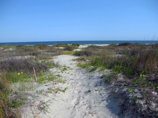
Park at Station 19 and walk out onto the beach.
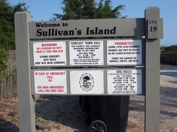
Foot traffic damages fragile dunes. Please proceed STRAIGHT onto the beach.
 Turn to your left (walk away from the lighthouse) and walk to a series of rocks in the sand. Try to find a rock at the high tide line at:
High tide line visible rock:
N 32 degrees, 45.401
W 079 degrees 50.388

View of high tide line rocks as of June 2011. Notice the difference in the look of these rocks now, as compared to the photo of the same area below.
Now walk North roughly 112 paces and find another rock. This rock provides the base for a series of (as of 2010) visible rocks leading inland,to the Post 6 beach trailhead of the Sullivan's Island Nature Trail.
(see Trailhead coordinates in waypoints feature. If you just walk inland, you will not be at the trailhead. Be sure you are walking North by using your compass!)
The rest of this log contains excerpts from the Nature Trail guide, of which a pdf may be viewed at:http://friendsofsies.org/archive_site/images/naturetrailbrochureFINAL_MAY_2010_small_file.pdf
It is also uploaded to google drive at: https://docs.google.com/open?id=0B56UGbpMk6tgQ3FyTTFiNGdTcnc
You may be thinking, "What are these rocks, and why are they here?"
These granite boulders were brought here by the Army Corps of Engineers in 1898. Why, you ask? Look out on the horizon, out in the ocean, can you see a row of rocks out there? Those rocks are part of two nearly six-mile long jetties built to prevent sand buildup in the shipping channel, to provide a definite channel for dredging and to provide a water break for ships entering and leaving Charleston Harbor. (The south jetty extends offshore from Morris Island.)
Although the jetties extend about five miles out into the sea, the first mile of rocks is submerged!
Where you are standing is where the northern Charleston Harbor jetty comes ashore! During times of extreme erosion, you can not only see the boulders extending into the water, sometimes you may see parts of the old World War II harbor submarine net, which is attached to this jetty, not far from shore! (do not swim within 100 yards of the rocks!)

SIES Students pose after a creative writing assignment in 2006 at the north jetty rocks.
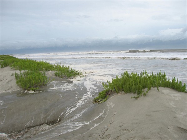
Locals speculate that some of our recent sand accretion is due to beach re-nourishment projects on Isle of Palms. Nearshore, southerly ocean currents and waves have moved this sand down the shoreline and deposited it here, completely covering these large boulders in just a few years.
What do you think our shoreline will look like in 20 years? In 50?
In addition to the sand re-nourishment projects to our North, there are a few sandbars offshore which appear to be gradually moving towards our island. Over a block of our town has accreted in the last 100 years, whereas Folly Beach, the island to the south of the harbor jetties, has seen two blocks of its town erode into the ocean.
The nearshore ocean currents along our shore tend to move sands north to south. Our island, just in the past 10 years, has seen dramatic changes in movements of sandbars off shore, large (almost lakes!) tidal pools, erosion during storms and rapid accretion in the central portions of the island.
As you continue up the beach, you will notice sand fencing which was placed in 2007. This fencing extended some 4 feet out of the sand at that time. Today, all but one foot is covered in sand in some areas.
As a side note, here are some interesting photos from this area during Hurricane Irene, August 26, 2011. The storm surge associated with this storm uncovered some of the rock jettys and cut through some of the seaward dunes. The force of the ocean currents is amazing! 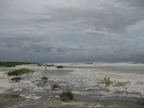

To get to the trailhead:
Walk North 65 paces to the Post 6 trailhead. DO NOT traverse the fragile dunes looking for the trailhead, follow the rocks until you see the post marker at:
Post 6 Trailhead:
N 32 degrees 45.465
W 079 degrees 50.403
Use your compass and walk 5 degrees to the North 17 paces to Post 7:
Post 7:
N 32 degrees 45.474
W 079 degrees 50.406
Hurricane Hugo washed out this gully area in 1989. In 2009, we added 7 sweetgrass plants, the same day we planted the ones at Post #1. On your way to Post #8, notice the potato-like gray bulbs on your left. What could these things be?
They are Earleaf or Dune Greenbrier (Smilax auriculata) bulbs. If you want to rid your yard--or this trail--of smilax, pulling on the vine or cutting it won’t get rid of the plant.
In order to get rid of this tenacious plant, you have to dig down and get not only the plant, but the root bulb as well.
Did You Know: Bulbs of greenbrier have been used to make smoking pipes?!
Follow the trail 52 degrees to the Northeast for 38 paces to Post 8:
N 32 degrees 45.482
W 079 degrees 50.396
You will notice abundant vines, plants and wildlife on our trail. It is good advice to avoid any plant with three leaves, just to be sure it is not Poison Ivy! One plant with three leaves that is OK to touch:
Beach Pea (Strophostyles helvola) Beach Pea spreads onto our trail and across the dunes, in the summer and fall as a crawling vine. The peas or seeds are eaten by birds and other wildlife. Another prolific vine on this part of the trail
is Virginia Creeper (Parthenocissus quinquefolia) which has five leaves, giving rise to another common name – Five Finger:“Leaves of five, let it thrive!” It is another prolific fruit-producer that is particularly valuable as a food resource for many migratory songbirds.
Follow the trail 70 degrees NE for 27 paces to
Post 9:
N 32 degrees 45.485
W 079 degrees 50.387
Look back at the Maritime Forest from this post. Notice the shrubs and trees are growing up and away from you at an angle! The plants around you are shorter than those just a bit inland.
Where are the plants and trees the tallest?
Close to the ocean or further away?
The plants and trees furthest from the ocean are the tallest. This is a fine example of the effects of salt spray or “salt pruning”.
Did You Know: In the 1980’s, our trail used to connect to the back of the PE field over to your left, but this part of the trail was abandoned due to the thick growth of poison ivy.
Please make sure you stay on the trail and do not venture off into areas where the surveyors have recently cut into this area!
Follow the trail 45 degrees NE for 28 paces to Post 10, one of our favorites:
N 32 degrees 45.491
W 079 degrees 50.381
As you walk down this dune, you will pass a large Wax Myrtle (Morella cerifera) on your left.
Did You Know: Wax Myrtle is also known as Southern bayberry
or candleberry because early American colonists used the fruit’s pale blue, waxy covering to make fragrant bayberry candles.
And: The tree’s distinctive, fragrant scent comes from oils contained in tiny glands on the leaves.
Next to the #10 post, you will find a cluster of Hercules’ Club, (Zanthoxylum clava-herculis). The natives of North America used the Hercules’Club, and the closely related Prickly Ash, to seek relief from toothaches, by chewing the bark. Hence, both the Hercules’ Club and the Prickly Ash are also known as “The Toothache Tree! Please remember Leave No Trace principles and do not try this! (Besides, our consultants tell us it tastes NASTY!) ”
Did You Know: This plant is also the native host, or food-plant, for caterpillars of Giant Swallowtail (Heraclides cresphontes), which is the largest butterfly in North America, having a wingspread of about 15 cm or 6 inches!
Between Posts 10 and 11 is a unique tree, a Tough Bully (Sideroxylon tenax), aka Tough Bumelia. Don’t worry, Tough Bully is not a mean kid on our nature trail, it is the name for a very local tree species that was discovered in South Carolina by Alexander Garden (a famous botanist for whom the gardenia flower is named, he lived from 1728-91). Mr. Garden sent a specimen of the plant to Linnaeus, (a famous naturalist who laid the foundation for the binomial nomenclature classifications), who named it in 1767. Both the common and scientific names of Tough Bully refer to the tough branches. It prefers dry sandy soil, found in common coastal plant communities, and is frequently associated with ancient shell-mounds or other shell deposits from native American Indians. Tough Bully is another prolific fruit-producer that supplies high-energy food for migratory songbirds.
Follow the trail for 21 paces 350 degrees NW to Post 11:
CAUTION: POISON IVY!!!
N 32 degrees 45.497
W 079 degrees 50.385
Stay on the trail! Poison Ivy is very close to our trail in a a few places and you can get a good, safe look at it here. Poison Ivy plants contain a chemical called Urushiol. It is this chemical that causes the typical allergic reaction and symptoms of Poison Ivy itching and rashes. Urushiol is found in the leaves, stems, and roots of Poison Ivy plants, which means that you can even get a rash in the winter, when a plant has lost all of its leaves! Be careful around, and do not touch poison ivy. If you, your clothing, or your pet come in contact with the plant, wash thoroughly with soapy water within 5 or 10 minutes of contact, before the chemicals have a chance to penetrate your skin.
Follow the trail NE for 96 paces to Post 12. STAY ON THE TRAIL. POISON IVY CLOSE in a few spots!
Post 12:
N 32 degrees 45.502
W 079 degrees 50.356
As you venture over the dune towards posts 13, 14 and 15, you will pass through an open grassland area. Different types of butterflies thrive in this area throughout the year.
Butterflies go through a process called metamorphosis. Adult butterflies mate and females deposit tiny pin-sized eggs on the appropriate host-plants, and the tiny caterpillar (larva, larvae) hatches from the egg after about 10 days. Caterpillars are eating machines, and they grow rapidly!
Insects and other invertebrates have no internal skeleton, but instead have a protective skin or exoskeleton on the outside. In order to grow, they must shed their skin, and in the case of caterpillars, they do so five times! After the fifth time,
they then change to the chrysalis, or pupa stage, which also lasts for about 10 days before the adult butterfly crawls out of the chrysalis skin and expands its wings. After an hour or so, it takes flight! Adult butterflies typically only live about two to three weeks, but during that time they find mates and begin another generation. Most butterflies and moths complete this “life cycle” (egg-caterpillar-pupa-adult) two or three times each growing season (April – September). Chrysalids or pupae that are formed in late summer or fall pass through winter (this is the most cold-tolerant stage), and the adults emerge the following spring.
The most abundant butterfly in our area is Cloudless Sulphur (Phoebis sennae eubule), so-named because it is most active on bright, sunny, “cloudless” days and its lemon-yellow, “sulphur” coloration. Cloudless Sulphur has up to four adult generations per year. Many thousands of these butterflies can occur regionally during the same time-period, causing their caterpillar food-plants in an area to become totally defoliated. Sometimes there will be so many butterflies by late summer, that they will venture out in search of food, with some traveling well out to sea. Some weaken and drown in the ocean, and beachcombers may see many of such dead butterflies that have been pushed ashore by wind and surf.
Giant Swallowtail adults emerge in April from chrysalids that passed through winter. They mate, and the females deposit eggs on Hercules’ Club or other citrus family plants.
Did You Know: The caterpillars are camouflaged to resemble bird droppings, an effective pattern to prevent them from being eaten by birds! Plus, the chrysalis is camouflaged to look like a broken twig!
Follow the trail 48 degrees NE 68 paces to Post 13:
N 32 degrees 45.517
W 79 degrees 50.340
Throughout the year this open grassland provides a resting station for migrating species, and a home to many others. One of the migrating species is the Monarch butterfly. Are there any butterflies in the area today? Can you identify them? Do you see any which have been caught, tagged and released to track their migration? (tags are placed on the side of the wing)
The Monarch Butterfly (Danaus plexippus) has one of the most miraculous mass migrations of any animal on Earth. Many millions of Monarchs migrate each fall from the northern United States and southern Canada through the Midwest to winter in high mountains of central Mexico--as far as 3000 miles southward to avoid winter cold! Fewer, but still likely millions of, Monarchs migrate south each fall along the Atlantic coast and some winter along the coast, here. Monarch caterpillars only feed on plants in the milkweed family. Milkweeds often attract female monarchs during the fall migration, and caterpillars are likely to be found on such plants from October through December, or until frost. Milkweeds contain chemicals that act as heart toxins in most vertebrates.
Have you heard the phrase:“You are what you eat”?
Monarch caterpillars, and chrysalids and adults, are chemically similar to milkweed, and the milkweed toxins protect the insects from most vertebrates. Another example of "you are what you eat" is the Gulf Fritillary (Agraulis vanillae nigrior), one of our most abundant butterflies, it is also bright orange, as are the caterpillars. The caterpillars only feed on passionflower– another plant that contains toxins.
Did You Know: Most vertebrates have color vision and have evolved to recognize bright colors, such as orange and red, as warning colors. Therefore, birds typically will not eat Monarchs or Gulf Fritillaries! However, the toxins do not affect many invertebrates, and both Monarch and Gulf Fritillary are eaten by spiders and praying mantids.
Walk NE for 15 paces to Post 14:
N 32 degrees 45.521
W 79 degrees 50.339
Facing inland, looking towards the school, you can view Trumpet Honeysuckle, (Lonicera sempervirens), our native honeysuckle. This plant is also called coral honeysuckle because of the coral-colored blooms. The trumpet-shaped flowers are not much used by insects but are very attractive as a nectar resource for Ruby-throated Hummingbird and Orchard Oriole. Facing the beach, you may see many stands of Bushy Bluestem, Andropogon tenuispatheus: This broom-sedge is widespread in our area, in and near damp depressions and wetlands. It is perhaps most often seen along highway shoulders on ditch banks and slopes.
Did You Know: Many “old timers” of the Lowcountry remember personally using, or their grandparents using, this plant to fashion brooms for their homes. (Perhaps they still do?--But please, don't you! Leave No Trace!)
Walk 60 degrees NW 11 paces to Post 15:
N 32 degrees 45.523
W 079 degrees 50.335
Just beyond post #15, on your way back to the primary beach path, you will pass Adam’s Needle, also called “Beargrass Yucca”. This interesting native yucca often forms colonies and specializes in sandy soils throughout much of the Southeast Coastal Plain. It is abundant in our Maritime Grassland. One way you can tell it apart from the other yucca species on the trail is by looking for the white “hairs” on each stem. It is also the primary caterpillar host plant for Yucca Giant Skipper (Megathymus yuccae), one of the largest skipper butterflies in North America. The caterpillar is parasitic as it bores into the growing point of the plant and feeds on the root, which kills the plant.
Now follow the trail 38 degrees NE 35 paces to the T-junction in the trail. Turn left and walk to the end of the trail, to the chain link fence, the actual trailhead and Post #1:
Gate/Post 1:
This post no longer exists as the post and signage area were cleaned out during the demolition of the old elementary school. Once a new school is constructed and this area-entry is reopened, we will update the listing. N 32 degrees 45.549
W 079 degrees 50.343
Sweetgrass Plants: This small colony of sweetgrass plants was added to the trail by the Pack 59 Cub Scouts in spring 2009 from seedlings provided by Billy McCord of the South Carolina Department of Natural Resources. Sweetgrass (a.k.a. gulf hairawn muhlygrass, Muhlenbergia sericea) is native to the coastal areas of the south Atlantic and the Gulf of Mexico. Sweetgrass is the foundation material for African-coiled basketry in the Southeast, especially in the Gullah/Geechee community.
Did you know:
“The art of basket-making was brought to South Carolina by slaves who came from West Africa more than 300 years ago. For generations the art has been passed down from mother to daughter to granddaughter. During the days of slavery in the Old South, women made functional baskets for the home using sweetgrass. Today’s baskets are made with sweetgrass, bulrush, and long leaf pine needles bound together by strips of the unopened center leaves of palmetto trees.”
In this sandy soil, sweetgrass must compete for nutrients with other species, such as the greenbriers and sand burs.
Now look to your right at the giant evergreen tree, a Southern Red Cedar, Juniperus virginiana variety silicicola, The scientific classification of this huge tree is:
Kingdom: Plantae – Plants
Subkingdom: Tracheobionta – Vascular plants
Superdivision: Spermatophyta – Seed plants
Division: Coniferophyta – Conifers
Class: Pinopsida
Order: Pinales
Family: Cupressaceae – Cypress family
Genus: Juniperus L. – juniper P
Species: Juniperus virginiana L.
Southern Red Cedar
Juniperus virginiana variety silicicola
Did you know: Pencils, cedar chests, closets, shingles and other products are made from cedar trees. The wood is extremely aromatic and repels insects.
Walk 160 degrees SE 20 paces to Post 2:
N 32 degrees 45.545
W 079 degrees 50.339
Look around you, what do you see?
If you did not know you were on a beach path, you may think you are standing in the Francis Marion Forest. In reality, you are standing on the edge of a unique, important habitat: a Maritime Forest. The Maritime Forest is a type of plant community that has evolved in tolerance to the harsh impacts of the land and salt water this near the ocean. These forests are shaped by wind and wind-blown sand and salt and evolved to prosper in sandy soils typical of barrier islands and the marine ecosystem. The Slash Pine (Pinus elliottii) was likely the most abundant pine of Maritime Forests when the first Europeans arrived in the Southeast. Slash Pine is more tolerant of salt than are other pines of the Southeast and is more resistant to wind than is Loblolly Pine (Pinus taeda), now the most common pine over most of the Southeast. Pines, and cedars, are in a plant group called conifers. The leaves of these trees are usually long and narrow, “needles”. Seeds of these trees develop in, and are protected by, cones.
How do we know what kind of pine tree this is? Needles of pines are arranged in groups or whorls, and the number of needles per whorl can be used to help identify a particular species.
Walk 19 paces, 148 degrees to the SE to Post 3:
N 32 degrees 45.541
W 079 degrees 50.335
Clearing of greenbrier has exposed a few specimens of Chickasaw Plum (Prunus angustifolia) in this thicket for you to see. Chickasaw Plum is a deciduous shrub that has clusters of fragrant white flowers in the early spring, followed by leaf growth and finally a yellow fruit which ripens to red in August or September. The flowers are much used by butterflies and other insects, including the Honey Bee (Apis melifera), and fruits are eaten by birds, raccoon and gray fox. Did You Know: The plums may be eaten fresh or made into jellies or preserves, and were cultivated by the Chickasaw Indians and other indigenous peoples before the arrival of Europeans.
Follow the trail 155 degrees to the SE for 34 paces to Post 4:
N 32 degrees 45.531
W 079 degrees 50.328
Notice that you have left the forest and have crossed one secondary dune. You are now standing in the swale, or low area, between the primary (beachfront or fore-dunes) and secondary dunes. As you continue toward the beach, you will cross over a series of dunes and swales as new dunes form with the aid of sand fencing, or simply by sand collecting in the wrack at the high tide line.
Shrubs and vines colonize in the swales or depressions between secondary dune ridges since these areas collect organic material as well as moisture from rain. The decomposition of organic material increases both soil nutrients and the ability of the soil to retain water.
Dune stabilization prevents erosion On accreting beaches, such as this one, these grasses colonize young dunes. Above-ground stems and leaves perform as natural sand fences by collecting sand. Broad, deep roots stabilize the dunes. This process promotes the growth of primary dunes. These plants are often planted on dunes to provide stabilization and potential dune growth. Sea Oats, Uniola paniculata, and other Maritime Grassland plants also stabilize secondary dunes by minimizing erosion until older secondary dunes are eventually colonized by shrubs and trees.
Many towns and other governments have ordinances, or rules, that attempt to confine humans to specific beach paths in order to prevent damage to dunes and dune plant communities.
Did You Know: Seed-heads of Sea Oats were once popular in dried flower arrangements, and some local governments have rules to prevent humans from picking these seed-heads.
Follow the trail 175 degrees South 45 paces to Post 5:
N 32 degrees 45.522
W 079 degrees 50.328
Before you reach the beach, notice the Maritime Grassland surrounding you
and the many types of plants growing in this sandy soil. This soil is nutrient-poor
and retains little moisture. Grasses and herbs are the main plant groups that have adapted to these harsh conditions.
Beach Morning Glory (Ipomoea imperati), also called Fiddleleaf Morning Glory, is a SC-listed rare plant that grows in Maritime Grasslands and on low dunes or beach flats very near the intertidal (flooded during typical high tides and dewatered during typical low tides) beach.
Dune Camphorweed, (Heterotheca subaxillaris) is a valuable nectar source for butterflies, including the migratory Monarch (Danaus plexippus), and other insects. Dune Camphorweed blooms during the summer and fall.
Why is it called camphorweed? Because if you crush the leaves, it smells like camphor! Phew!
Continue straight out to the beach to make your way back home.
Do note that if you wish to find this Post 5 entrance from the beach side, the trailhead is at:
N 32 degrees 45.508
W 079 degrees 50.323
Please walk STRAIGHT out to the beach and not across the fragile dune systems.
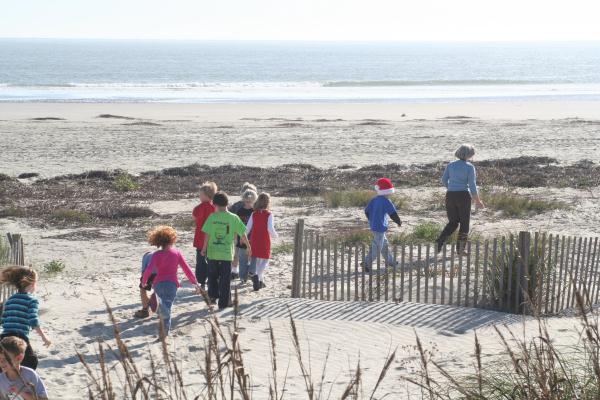
SIES Students walk out to the beach for a creative writing assignment in December 2007. Notice how much the dunes have accreted in this short span of time. The sand fencing had recently been installed before this picture was taken.
SIES The same area, Station 20 trailhead,in June of 2011.
Once you reach the beach flats, walk approximately 225 paces 250 degrees NW and you will be back at the rocks and jetty area where you started.
We hope you learned a bit about our island, the wonders of our powerful ocean and weather, which move sand around and constantly sculpt our beaches.
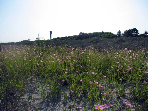
Wildflowers grow in a swale between two new dunes in front of the Station 20 trailhead in June, 2011.
If you are a scout, we hope you are now proficient in using your gps and compass!
Thank you for visiting our trail. Remember, Leave No Trace!