Deutsche
Beschreibung:
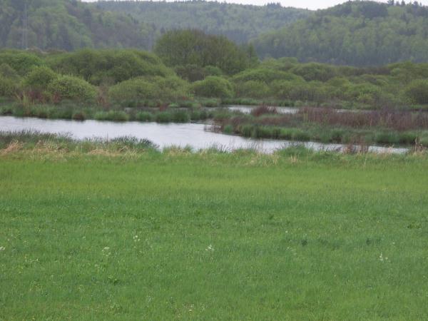
Der Schmiechener See liegt in einem Mäander des Urdonautals
(seit ca. 150000 Jahren fließt die Donau in ihrem heutigen Bett)
auf einer wasserundurchlässigen Tonschicht, die ca. 30-40m stark
ist. Das komplette Einzugsgebiet ist ca. 10,5m² km groß. Der See an
sich besitzt eine maximale Fläche von ca 51ha, die er jedoch nur im
Frühjahr zur Schneeschmelze erreicht. In regenarmen Jahren kann der
See fast vollständig austrocknen.
Im Schnitt ist der See ca. 0,5m tief, die tiefste Stelle kann ca.
2m erreichen.
Glaubt man Georg Wagner, dann handelt es sich bei dem
Schmiechener See um einen reinen Karstsee. Vorraussetzung hierfür
ist, dass eine abflusslose, nach unten abgedichtete Hohlform auf
den Karstwasserspiegel trifft.
Es gibt keinen überirdischen Abfluss, die Entwässerung erfolgt
ausschließlich durch verdunsten oder versickern.
Lillich und Kuhn jedoch stellen die These auf, dass der See
ausschließlich durch Oberflächenwasser gespeist wird. Den einzigen
Zufluss, den Siegenbach werdet ihr auf eurer Runde um den See
überschreiten.
Dass das Wasser nicht ausschließlich verdunstet kann durch den
nicht erhöhten Salzgehalt bewiesen werden. Im Osten des Sees wurde
eine poröse Tonschicht festgestellt, durch die das Wasser
insbesondere bei hohem Pegel versickern kann.
Bereits seit 1973 ist der Schmiechener See ein
Naturschutzgebiet, jedoch nicht wegen seiner geologischen Struktur,
sondern aufgrund seiner außergewöhnlichen Flora und Fauna. Da sich
der Wasserstand ständig ändert sind hier vor allem Amphibien
heimisch. Feuchtigkeitsliebende Pflanzen finden hier einen
Lebensraum, was auf der Schwäbischen Alb eher selten der Fall ist.
Welche Tier- und Pflanzenarten hier heimisch sind werdet ihr auf
Eurem ca. 5km langen Weg um den See erfahren...
English
description:
The Schmiechener See (Lake of Schmiechen) ist located at a
meander of the former Danube (since about 150000 years the Danube
has its new riverbed). The Ground consists of a impermeable clay
layer which ist 30-40m thick. The overall drainage area is about
10.5 km² but the lake itself has a maximum area of 126acre. This
area is only reached in spring during the snow melts. In years with
little rainfall the lake fell almost dry. The average of the depth
is about 0.5m the deepest spot is 2m.
If you follow the geologist Georg Wagner, the Schmiechener See
is a complete karst see. This means that there is a flat cavity
with an impermeable ground this cavity corresponds with the
waterlevel of the the surrounding karstic area (at high level the
water can flow in, if the level of the surrounding in lower the
water remains there)
There is no water outlet at the surface, the drainage can only
happen by percolation or evaporation.
Contrary to this assumption Lillich and Kuhn state that the lake
is solely filled by surface water. The only inflow is from the
creek called Siegensbach, you will cross during your walk.
The evidence that the water will not evaporate completely is the
concentration of salt in the lake. The salt level isn´t increased,
so a part of the water must drain away. At the east of the lake
there is a porous clay layer there the water can percolate
especially at high water levels.
Since 1973 the Schmiechener See is a nature protection area, not
because of its geologie but because of the extraordinary flora and
fauna. Due to the permanent changing water level a lot of
amphibians are domestic. There are also a lot of plants which need
wetness. Such areas are not common at the Swabian Alb. Which kind
of plants and animals are domestic in the area you can discover at
your 5km walk around the lake ...
Logbedingungen:
Beantworte die Fragen an den einzelnen Infotafeln und schicke
dann eine email mit Deinem Cachernamen und dem derzeitigen
Wasserstand an (A)(B)(C)@onlinehome.de
auf einer der Tafeln ist zu finden, dass der Untergrund durch
Schwemmmaterial abgedichtet wurde, dies ist Vorraussetzung für die
Seebildung. Die Schwäbische Alb an sich besteht im wesentlichen aus
wasserdurchlässigem Gestein. Aus welchem?
Lade ein Bild hoch, welches Dich und/oder Dein GPS an der
Plattform zeigt.
Log Terms:
answer the questions at the information charts and send an email
with your account name and the current water level at
(A)(B)(C)@onlinehome.de
at one of the information tables you will find that the
underground there first had been sealed bysettling sediment. This
was the pre-condition for the formation of the lake. The stones
which form the swabian alb are permeable to water. Which stones
form the swabian alb?
upload a picture which shows you and/or your GPS at the
platform