THE ATCHAFALAYA BASIN
This cache is at the Louisiana Weclome Center, just off of I10 next to the Atchafalaya swamp.
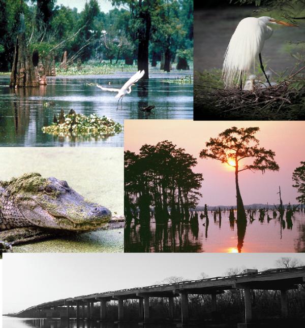
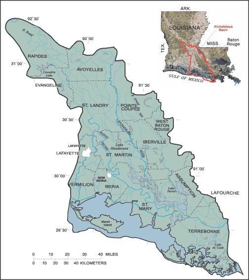
Louisiana’s Atchafalaya Basin is the nation’s largest swamp wilderness, containing nationally significant expanses of bottomland hardwoods, swamplands, bayous and back-water lakes. It includes the Atchafalaya River, one of five major distributaries of the Mississippi River, which discharges 30 percent of its flow into the Atchafalaya. Ecologically, the Atchafalaya basin has four sections. To the north are woodlands and farmlands. The middle section contains North America’s largest river basin swamp, a natural paradise of exotic plants and animals. The swamp attracts hunters, fishing, and boating enthusiasts, and nature photographers. Farther south is marshland. Finally, where the Atchafalaya River empties into Atchafalaya Bay, a new delta is being formed. The entire region supports half of America’s migratory waterfowl and yields 23 million pounds of crawfish annually. It is home to over 200 species of birds, including egrets, ibises, and anhingas. Endangered species include peregrine falcon, Bachman’s warbler, and the Louisiana Black Bear.
GEOLOGY
Geologically, the Atchafalaya river has served periodically as the main channel of the Mississippi River, which is the second longest river in the United States, with a length of from its source in Lake Itasca in Minnesota to its mouth in the Gulf of Mexico, through the process of delta switching. This process is now largely managed by the U.S. Corps of Engineers starting at the Old River Control Structure, which is an artifice built by the U.S. Army Corps of Engineers at the divergence of the Mississippi and Atchafalaya Rivers in order to maintain the water distribution between the two, at 70% and 30%, respectively. The control of the river's floods, along with those of the Mississippi, has become a controversial issue in recent decades. It is now widely suspected that the channeling of the river and subsequent lowering of siltation rates has resulted in severe degradation of the surrounding saltmarsh wetlands.
LOGGING REQUIREMENTS
We encourage you (not required) to take a picture of yourself and/or caching team and post it on this cache page. To log this earthcache as a find, you must email the answers to the following questions and email them to the cache owner:
1. How often does the Mississippi river channel change its direction to flow directly through the Atchafalaya basin? Currently, the Atchafalaya Basin covers approximately one million acres. How large was it in the past? The answers are on a display in the Atchafalaya Welcome Center.
2. At the listed coordinates (outside in the back of the Atchafalaya Welcome Center), there are numerous life sized bronze statues of animals found in the Atchafalya basin. How many of them are reptiles and how many different reptiles are there?
3. Keeping in mind that you are on the edge of a swamp, is the ground composed of sedimentary, igneous, or metamorphic soil?
 To learn more about earthcaches, including how to develop one of your own click here Earthcache.org. You can also obtain one or more of the following levels of the Earthcache MastersProgram:
BRONZE (log three or more earthcaches in at least two or more states/countries
SILVER (log six or more earthcaches in at least three or more states/countries and develop one earthcache),
GOLD (log twelve or more earthcaches in at least four or more states/countries and develop two earthcaches), or
PLATINUM (log twenty or more earthcaches in at least five or more states/countries and develop three earthcaches).