Der Rundweg durch den Muschelkalk EarthCache
Der Rundweg durch den Muschelkalk
-
Difficulty:
-

-
Terrain:
-
Size:  (other)
Please note Use of geocaching.com services is subject to the terms and conditions
in our disclaimer.

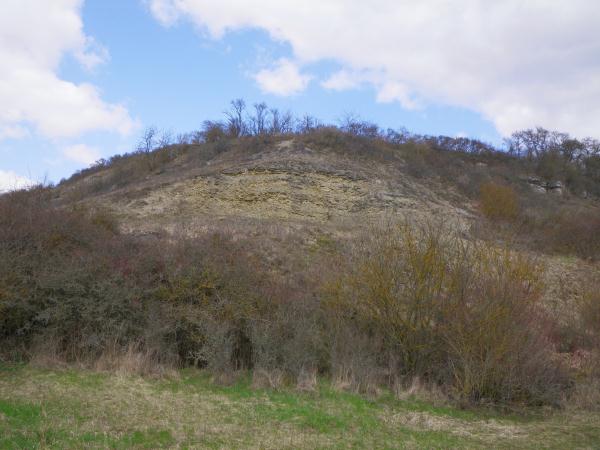
In diesen Geocache geht es um den Muschelkalk. Es ist eine
Rundwanderung durch das Gebiet Bad Neustadt - Löhrieth -
Strahlungen - Salz (Rund um den Grasberg). Die Gesamtstrecke
beträgt ca. 5 km und hat einen Höhenunterschied von ca. 90 m. Es
muss der ganze Rundweg gegangen werden. Zu jeder Tafel muss eine
Frage beantwortet werden.
Dies ist kein Drive-in Cache, deshalb auch die D3 und T3 Einstufung
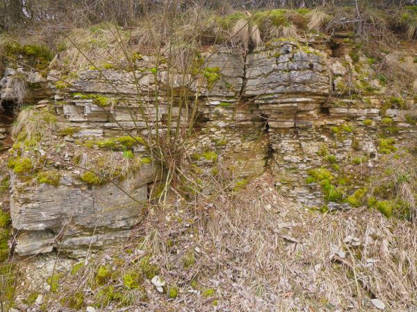
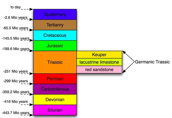
Über 8 Stationen wird der Muschelkalk anschaulich dargestellt und
somit die Erdzeitgeschichte vor 200 - 250 Millionen Jahren. Dies
ist der Zeitraum des Trias. Der Trias teilt sich in drei
Zeitabschnitte, aus denen folgende Gesteinsschichten entstanden
sind:

Buntsandstein
(Vorkommen westlich von Bad Neustadt)
Muschelkalk
(Vorkommen östlich des Saaletals, Salzburg und Grasberg)
Keuper
(Vorkommen östlich von Löhrrieth und in den Haßbergen)
Zuerst lagerten sich rote, braunrote und grünliche Sandsteine ab
und bildeten die Schichten des Buntsandsteines. In Laufe der Zeit
entstand das Muschelkalkmeer. Es lagerten sich Kalksteine und
Merkel ab und bildeten den unteren Muschelkalk. Später wurde das
Gebiet vom Urmeer Tethys teilweise abgetrennt, es entstanden die
Schichten des mittleren Muschelkalkes. Danach kam es zur erneuten
Überflutung und es entstand die Gesteinsschicht des Oberen
Muschelkalkes. Danach kam die Zeit der Austrocknung und Überflutung
im Wechsel, es entstand die Gesteinsschicht Keuper. Das Germanische
Becken wurde endgültig zum Festland.
Folgt dem Wegweiser:
Folgende Themen in Bezug auf dem Muschelkalk werden anschauliche
dargestellt
Tafel 1 - Die geologische
Geschichte
Tafel 2 - Die Auswirkung
auf Flora, Fauna und Geologie
Tafel 3 - Trinkwasser und
Trinkwasserschutz
Tafel 4 - Fossilien im
Muschelkalk
Tafel 5 - Die Auswirkungen
auf Landwirtschaft
Tafel 6 - Der Steinbruch
als Lebensraum
Tafel 7 -
Aussichtsplattform Steinbruch
Tafel 8 - Panorama
Beantworte zu jeder Tafel
eine Frage oder fotografiere bei Tafel 7:
Frage
1 Welcher Zeitabschnitt beginnt mit dem Auftreten der ersten
Säugetiere?
Frage
2 Was sieht man am brachliegenden Südhang?
Frage
3 Wie heißt die wasserundurchlässige Gesteinsschicht?
Frage
4 Wie dick ist die Muschelkalk-Schicht?
Frage
5 Welche Bodengüte gibt es hier auf dem Grasberg?
Frage
6 Welche Gesteinsschichten sind in der Karte eingezeichnet
(4 Stück)?
Frage
7 Mache ein Bild von der Aussichtsplattform aus.
(Am Schönsten wäre ein Bild von dir mit dem Steinbruch im
Hintergrund, aber das ist optional.)
Frage
8 Wie viele Jahre ist der Grasberg älter als die
Rhönkuppen?
--------------------------------------------------------------------------------------------------------------
This geocache deals with Lacustrine Limestone. It is a walking tour
in the area of Bad Neustadt, around a hill called Grasberg. You´ll
reach your start point at the end of the tour after 3 miles again.
The difference in height is only 100 yards. You have to walk the
whole tour and visit the eight information boards. You have to
answer a question for each board. This is not a drive-in cache,
therefore it is rated with D3 and T3.
The geological formation lacustrine limestone is explained simply
but precisely at eight places on the tour. The geological era
concerned is the Triassic period (200 - 250 millions of years
ago).
In the Triassic period three formations have been built which can
be seen in this area:
Red
Sandstone (to be found west of Bad Neustadt)
Lacustrine
Limestone (to be found east of the valley of the Saale, the
castle Salzburg and the hill Grasberg)
Keuper
(to be found east of Löhrieth and in the region Hassberge)
At first red and green Sandstone and Brownstone have been
deposited. These are the layers of the „Colored
Sandstone“. In the course of time the Lacustrine Limestone
sea has developed. Limestones and Marl have been deposited. Later
this area has been separated from Tethys Sea. The layers of the
middle Lacustrine Limestone came into being. Afterwards the area
has been flooded again and the layer of upper Lacustrine Limestone
has been built.
Then an era of changes between flooding and drying up has followed
in which the layer Keuper has been built. Afterwards the German
Basin finaly has become mainland.
Now follow the
sign:
The following issues are dealt with
Board 1 - Geological
History
Board 2 - How This History
Influenced Flora, Fauna And Geology
Board 3 - Drinking Water
And How It Is Saved
Board 4 - Fossiles In
Lacustrine Limestone
Board 5 - How Agriculture
Is Influenced
Board 6 - What Lives In The
Stone Pit
Board 7 - Viewing
Platform
Board 8 - Panorama
Answer a question at each
board or take a picture at board 7:
Question 1:
Which era has started when the mammals have come into being?
Question
2: What do you see at the slope facing south which lies
fallow?
Question
3: How is the water-impermeable layer called?
Question
4: How thick is the Lacustrine Limestone layer?
Question
5: Which is the quality of the soil here on the
Grasberg?
Question
6: Which layers are shown on the map? (List four
layers)
Question
7: Take a picture from the platform. We would prefer a
picture showing you in front of the stone pit, but this is
optional.
Question
8: How much older is the Grasberg compared with the hilltops
in the Rhoen?
Additional Hints
(No hints available.)