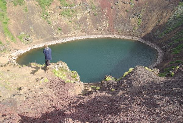
Kerið (occasionally Anglicized as Kerith or Kerid) is a volcanic crater lake located in the Grímsnes area in south Iceland, on the popular tourist route known as the Golden Circle. It is one of several crater lakes in the area, known as Iceland's Western Volcanic Zone, which includes the Reykjanes peninsula and the Langjökull Glacier, created as the land moved over a localized hotspot, but it is the one that has the most visually recognizable caldera still intact. The caldera, like the other volcanic rock in the area, is composed of a red (rather than black) volcanic rock. The caldera itself is approximately 55 m (180 ft) deep, 170 m (560 ft) wide, and 270 m (890 ft) across. Kerið’s caldera is one of the three most recognizable volcanic craters because at approximately 3,000 years old, it is only half the age of most of the surrounding volcanic features. The other two are Seyðishólar and Kerhóll.
While most of the crater is steep-walled with little vegetation, one wall is sloped more gently and blanketed with a deep moss, and can be descended fairly easily. The lake itself is fairly shallow (7-14 metres, depending on rainfall and other factors), but due to minerals from the soil, is an opaque and strikingly vivid aquamarine.
Formation
Although volcanologists originally believed Kerið was formed by a huge volcanic explosion, as is the accepted norm with volcanic craters, more thorough studies of the Grímsnes region failed to find any evidence of such an explosion in Kerið. It is now believed that Kerið was a cone volcano which erupted and emptied its magma reserve. Once the magma was depleted, the weight of the cone collapsed into the empty magma chamber. The current pool of water at the bottom of the crater is at the same level as the water table and is not caused by rainfall.
Source: Wikipedia
For the valid "cache found" log:
Feel free to upload a photo of you in front of the crater, it is not required but greatly appreciated!
1) And send to us via profile e-mail answers to these four questions:
¤The name of this Earthcache.
¤Mention three other Volcanic calderas of the world.
¤From who should you get permission to take commercial pictures of the crater?
¤Describe the color and texture of the scoria.