The 2,208 acres of Lost Maples lie in the northwestern corner of Bandera County and along the eastern edge of adjacent Real County. The park contains relict stands of bigtooth maple trees and was purchased from private landowners by the Texas Parks and Wildlife Department in 1973 and 1974 in order to preserve its unique biological and scenic resources. When purchased, it was designated a state natural area, and in 1980 the Heritage Conservation and Recreation Service made it a national natural landmark. The park, which is located along the steep, rugged upper portion of the Sabinal River watershed, is surrounded by high canyon walls that have made it a natural refuge for plants and animals for thousands of years. The most spectacular and popular scenic attraction is the autumn color of its isolated population of bigtooth maples (Acer grandidentatum). This vivid display of fall colors has drawn visitors from around the state for many years.
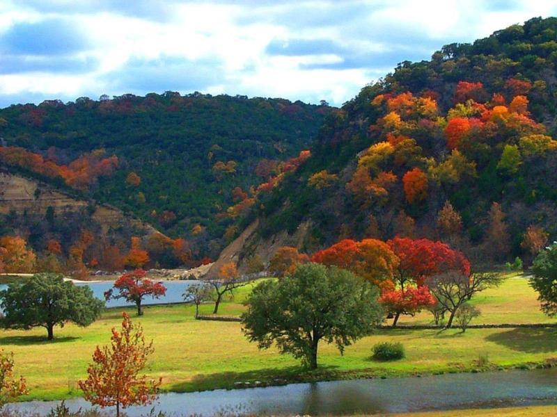
Most valley bottoms in the park have deep, dark brown silty clay (Krum series) or clay loam (Pratley series). Deposits of gravel, sand, and loam (Orif-Boerne association) lie within a few hundred feet of the Sabinal River. All of these soils are well drained, have free calcium carbonate throughout their profiles, and are moderately alkaline. Many diverse species of trees are found here, including the Bigtooth Maple, which was discovered far removed from any maple forest, and thus gave the area the name "lost maples").
GEOLOGIC HISTORY
100 Million Years Ago -- Mesozoic Era, Cretaceous Period:
During the long Cretaceous period, a shallow Mexican Sea washed across most of Texas At its peak, it extended northward all the way to the Arctic Ocean. The Central Texas Platform lay near the southwestern extremity of a vast northern continent called Laurasia. Consisting of North America, Europe and most of Asia, Laurasia was separated from the southern continents by the developing Mexican Sea and young North Atlantic. The climate here was tropical with massive coral reefs forming in Texas, Mexico and the Yucatan.
50 Million Years Ago -- Cenozoic Era, Tertiary Period, Eocene Epoch:
The Mesozoic era closed with the forming of the Rocky Mountains and the elevation of central North America. By the second epoch of the Tertiary period, the Eocene, central Texas was a broad, low-lying limestone plain. Sluggish rivers meandered across the flat terrain. forming broad floodplains with sandy or muddy deltas at their mouths. The coastline consisted of sandy barrier islands with protected lagoons, bays and marshes, much like the present coast but more inland.
20 Million Years Ago -- Cenozoic Era, Tertiary Period, Miocene Epoch:
The Miocene was again a period of mountain building. In central Texas, the rock strata rose, but the coastal deposits resisted the change. The strata cracked and broke along a narrow zone running from present-day Fort Worth to Waco, Austin, San Antonio and westward to Del Rio. Geologists have named it the Balcones Fault Zone and in places it forms a noticeable escarpment. This faulting did not happen overnight , but over thousands of years until the interior plateau stood 500 to 800 feet above the coastal plain. The once-sluggish rivers began stripping away looser deposits, cutting valleys and canyons headward into the plateau.
5 Million Years Ago -- Cenozoic Era, Tertiary Period, Pliocene Epoch:
During the Pliocene epoch, the last of the Tertiary period, North America experienced a gradual cooling trend. By two million years ago, the "Ice Ages" had begun, marking the start of the Pleistocene epoch and the Quaternary period. Vast sheets of ice advanced across the continent four different times. Texas was never buried by the ice, but its climate was distinctly cooler and wetter than now. During these times, both the eastern and western forests advanced until they intermingled.
Between the glacial ages, the climate was at least as warm and dry as the present. Whole forests were wiped out, victims of the heat and drought. Yet remnants could survive in sheltered spots such as here in Sabinal Canyon.
Before the Pleistocene Ice Ages, the ancestral stock had already appeared from which the sugar maples would evolve. It spread across the northern part of the continent with a western type in the mountains and an eastern type in the northeastern forests.
As the ice advanced, the North American forests migrated southward. The maples migrated also. The western type became the bigtooth maple. During one of the glacial advances, it reached Balcones Escarpment and the Sabinal Canyon.
Today -- Cenozoic Era, Quaternary Period, Recent Epoch:
Canyons are still being cut into the Edwards Plateau. Youthful, V-shaped valleys with steep, narrow walls characterize the headwaters of rivers and the smaller tributaries such as at Lost Maples State Natural Area. The Glen Rose Formation, made up of a collection of limestone, shale, marl and siltstone beds underlies a thicker layer of solid marine limestone known as the Edwards limestone. This sequence of strata, Glen Rose below, Edwards above, is found throughout this area. Further downstream occur broader, U-shaped valleys filled with alluvial sediment.
AREA BIOLOGY
As the ice retreated at the end of the last ice age and the climate warmed, trees such as the bigtooth maple retreated to more hospitable climes. A few populations of bigtooth maples, however, have survived in areas such as here in the Sabinal Canyon. The shade provided by steep canyon walls along with the rich soil and plentiful spring-fed water found in the canyon bottoms have provided an envionment where this typical "northern tree" can survive.
THE CACHE
To complete the earthcache, you will need to make two stops in the park to get information, collect data, and/or take photos (optional). Don't worry, the stops are close together and you can do the tasks in any order.
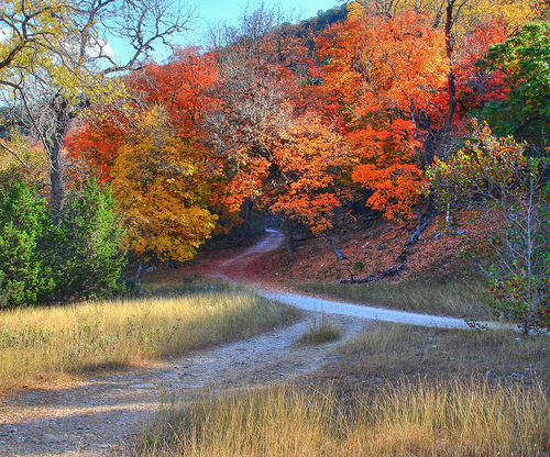
The stops are along the Maple Trail, a short walk from convenient parking. Drive straight back into the park to the trailhead at N29 49.000, W99 34.245. At the posted coordinates, along the Maple Trail (N29 49.135 W99 34.256), you will find some large boulders that have fallen from the canyon wall. Steep walls such as these provide the shade necessary for the maples to survive. How high do you estimate the cliff above you to be? What type of limestone do you think the boulders are composed of, Edwards or Glen Rose? If you like, take a selfie or picture with your GPS visible at this spot and post it in your log.
In the vicinity of N29° 49.117 W99° 34.265 (Waypoint V1), there's a plaque about the nearby Travertine Spring. What can destroy the work of centuries? My understanding is that this sign may have recently been moved, so if anyone has better coordinates please let me know or post them in your log.
Email the answers to me , but DO NOT post them in your log, even if encrypted. Alternatively, you may send your answers via the GC.com messaging system (you may also attach your verification photo to your message, if you'd rather not post it in your log). Finds that are claimed without the required info being sent may be deleted.
Take the time to enjoy the rest of the park. There are plenty of hiking trails to enjoy and traditional caches to find, including the oldest active puzzle/mystery cache in the state of Texas (GC2CE -- Where's that Maple?)!
This cache created by a Platinum Earthcache Master
See Earthcache.org for more info on how to become an Earthcache Master.
Other Educational Information:
References:
1. Educational displays, Lost Maples State Natural Area visitor's center.
2. Wikipedia
3. Handbook of Texas Online
4. Roadside Geology of Texas, page 179 (Darwin Spearing, 1991)
Congratulations to twobagels for being FTF!