Located at the heart of Five Corners intersection, which is itself the heart of Murrayville, the pumphouse is a physical reminder of the historic method of obtaining water in the community. While functioning as the only water source, the pumphouse was also a social meeting place where residents gathered to collect water from the overflow trough and to water their horses and cattle. Community folklore still claims that the water collected here makes the best pickles.
The pumphouse site has supplied water to the residents of Murrayville, one way or another, continuously since 1911. Community resident Rod Cummings first pumped water from his artesian well to Belmont School and the Municipal Hall using a hydraulic ram (1911) and then an electric pump (1928). Built in 1928, the purpose of the pumphouse was to shelter the electric pump. The pump was shut off in 1982, but the site remains for historical value, and water still flows freely from the spout. The pumphouse was designated an historic site by the Township of Langley in 2004.
The constant flow of water from the pipe is supplied by gravity, draining water from the Hopington Aquifer.
This is an example of a flowing Artesian Well. An artesian well allows water that has traveled through porous rock into a confined aquifer, to rise to the surface. This pumpless well seems to defy gravity because the pressure that builds up between layers of rock gets relieved when the water finds a path to the open air.
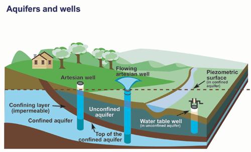
An aquifer is an underground layer of water-bearing permeable rock or unconsolidated materials (gravel, sand, silt, or clay) from which groundwater can be usefully extracted using a water well. If the aquifer is confined by an impermeable layer (an aquitard), a break in the aquitard can allow water to freely flow out due to internal pressure in the aquifer. The amount of flow from the well is proportional to the elevation change in the confined aquifer.
This earthcache is placed with permission from the Township Of Langley
In order to log this earthcache you must email me the answers to the following two questions:
1:) Using an appropriate measuring device (1 liter water bottle, etc.) estimate the amount of liters per minute of water flow from the pipe. How much water flows out of this pipe per year? (this number may surprise you!)
2:) Using your GPSr, find the elevation of the water trough and the elevation of the top of the hill to the east up 48th ave. What is the difference in meters?
Optional Task:) You are encouraged to post pictures of yourself (or your GPSr) at the well. Although this is no longer required by the earthcache guidelines, it would help confirm your "find" in the event that your answers are incorrect.
*Please note* This is untreated water, in an urban environment. Although I believe that the water is safe to drink, and has historically been used for drinking, cachers are urged to use their own judgement in whether to taste the water or not. I have been drinking untreated water from this same aquifer for over 30 years, without health issues.
* "Found it" logs without the required email answers will be removed, as per Earthcache guidelines.*