Topographical Basepoint of Hungary EarthCache
Topographical Basepoint of Hungary
-
Difficulty:
-

-
Terrain:
-

Size:  (not chosen)
Please note Use of geocaching.com services is subject to the terms and conditions
in our disclaimer.


Geodesy also called
geodetics, a branch of earth sciences, is the scientific discipline
that deals with the measurement and representation of the Earth,
including its gravitational field, in a three-dimensional
time-varying space. Geodesists also study geodynamical phenomena
such as crustal motion, tides, and polar motion. For this they
design global and national control networks, using space and
terrestrial techniques while relying on datums and coordinate
systems.
In geodesy, point or terrain heights are "above sea level",
an irregular, physically defined surface. Therefore a height should
ideally not be referred to as a coordinate. It is more like a
physical quantity, and though it can be tempting to treat height as
the vertical coordinate z, in addition to the horizontal
coordinates x and y, and though this actually is a good
approximation of physical reality in small areas, it quickly
becomes invalid for regional considerations.
Heights come in the following variants:
- Orthometric heights - The orthometric height is the
distance H along a line of force from a given point P at the
physical surface of an object to the geoid.
- Normal heights - Normal heights are heights above sea
level, one of several types of height which are all computed
slightly differently.
- Geopotential heights - is a vertical coordinate
referenced to Earth's mean sea level - an adjustment to geometric
height (elevation above mean sea level) using the variation of
gravity with latitude and elevation.
Each has its advantages and disadvantages. Both orthometric and
normal heights are heights in metres above sea level, whereas
geopotential numbers are measures of potential energy (unit:
m2s-2) and not metric. Orthometric and normal
heights differ in the precise way in which mean sea level is
conceptually continued under the continental masses. The reference
surface for orthometric heights is the geoid, an equipotential
surface approximating mean sea level.
 |
The term above mean sea level (AMSL) refers
to the elevation (on the ground) or altitude (in the air) of any
object, relative to the average sea level datum. AMSL is used
extensively in radio (both in broadcasting and other
telecommunications uses) by engineers to determine the coverage
area a station will be able to reach. It is also used in aviation,
where all heights are recorded and reported with respect to AMSL
(though also see flight level), and in the atmospheric
sciences.
The concept of a "mean sea level" is in itself rather artificial,
because it is not possible to determine a figure for mean sea level
for the entire planet, and it varies quite a lot even on a much
smaller scale. This is because the sea is in constant motion,
affected by the high and low pressure zones above it, the tides,
local gravitational differences, and so forth. The best one can do
is to pick a spot and calculate the mean sea level at that point
and use it as a datum. For example, the Ordnance Survey uses a
height datum based on the measurements of mean sea level at a
particular gauge at Newlyn, Cornwall from 1915 to 1921 for their
maps of Great Britain, and this datum is actually some 80 cm
different from the mean sea level reading obtained on the other
side of the country. An alternative is to base height measurements
on an ellipsoid of the entire earth, which is what systems such as
GPS do. In aviation, the ellipsoid known as World Geodetic System
84 is increasingly used to define mean sea level. Another
alternative is to use a geoid based datum such as NAVD88. |
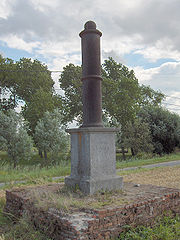
Nadap
The first levelling in Hungary has been carried out by the Military
Geography Institute of Vienna between 1873-1913. The average level
of the Adriatic Sea has been chosen for the base level and has been
measured on Molo Sartorio’s scale in Trieste, 1875. Years
later the level has been measured again with the result of an
alteration of 9 cms hence the Base Level of Nadap has been
initiated. That means the height level is based not on the sea
level but on a virtual level which is 173,8385 metres below the
Nadap Basepoint.
Later on, seved additional main basepoints hae been initiated to
help further levelling. Only the Nanap one can be found within the
current borders of Hungary which is the reason for the re-usage of
the Base Level of Nadap in the levelling process of 1921 and 1949.
The Nadap Basepoint’s height above sea level has been
determined as 173,8385 metres in 1888. The Nadap one is the most
stable point of Hungary in terms of geology.
It’s been ordained in the Eastern Bloc in 1960 to change from
the Adriatic base level to the Baltic one. That resulted the shift
to the Baltic (Kronstadter) base level which is 67,47 cms higher
than the Level of Nadap. The height of Nadap Basepoint is 173,1638
metres according to the Baltic base level.
To log your visit at this earthcache,
- please email the answers to the following
questions:
- How much is the difference between the average level of the
Baltic Sea and Adriatic Sea?
- What was the reason for choosing this site for the
fundamental bench mark?
- Measure the height of the basepoint -
(magasságszelvény)
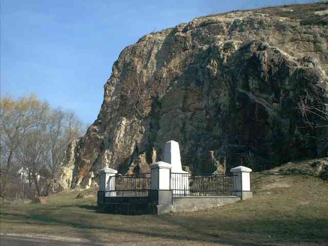
- Take a photo of yourself at the site, similar to the one
provided within the listing.
Happy caching!
vissza a lap tetejére
A geodézia vagy földméréstan, a Föld alakjának és méreteinek
meghatározásával, valamint a Föld felszínén levo természetes
alakzatok és mesterséges objektumok alakjelzo pontjainak
meghatározásával foglalkozó tudomány.
A geodézia az élet sok területén nélkülözhetetlen; a földbirtok- és
országhatárok, valamint az épületek alapjainak kituzése, a térképek
készítéséhez szükséges terepfelmérések elvégzése, de a földrajzi
helymeghatározás és a navigáció is a földméréstan feladata. A
geodézia és a térképészet rendkívül szorosan kapcsolódik egymáshoz,
mivel a térkép nem más, mint a földmérok által meghatározott pontok
helyzetének grafikus ábrázolása, esetenként kiegészítve a
rendeltetésének megfelelo tematikus információkkal (turista-,
autós-, topográfiai- stb. térképek).
Fontos és gyakori geodéziai munka a szintezés; ennek során a pontok
egymás közti magasságkülönbségét és/vagy a pontok alapfelület
(tengerszint) feletti magasságát mérik. Ezeket a munkákat az
Országos Szintezési Hálózat alappontjaira támaszkodva hajtják
végre. Építkezéseket minden alkalommal szintezés elozi meg, hogy
biztosítsák: vízszintes, sima felületre épül az építmény.
Földmérési munkák végzése során a felmérendo pontokat szükséges
megjelölni valamilyen módon, ez történhet ideiglenes módon, amikor
csak a munkálatok idejére jelöljük meg a pontokat, a fontosabb
pontjeleket azonban állandósítani kell.
A tengerszint feletti magasság vagy abszolút magasság a földrajzi
pontok magasságának méréséhez meghatározott mérték. Alapja
általában a legközelebbi tenger középvízszintje.
Nadap
 |
Az elso országos szintezést a bécsi Katonai
Földrajzi Intézet végezte 1873-1913 között. Alapszintnek az
Adriai-tenger középszintjét választották, amelyet a trieszti Molo
Sartorio mércéjén 1875-ben határoztak meg. Késobb újra megmérték a
középvízszintet, amely 9 cm-rel eltért az elozotol, ezért
bevezették a nadapi alapszintet. Ez azt jelenti, hogy a magasság
nem a tengerhez képest, hanem egy képzeletbeli felülethez képest
értendo, amely 173,8385 méterrel van a nadapi jel alatt. Késobb hét
foalappontot létesítettek a további mérések megsegítésére. Ezek
közül a mai Magyarország területére csak a nadapi esik, ezért mind
az 1921-es, mind pedig az újabb, 1949-ben kezdodött
országfelmérésnél ebbol kellett kiindulni. A Nadap foalappont
tengerszint feletti magasságát 1888-ban végzett mérés alapján |
| 173,8385 m-ben állapítottak meg. Ez a pont az
ország geológiai szempontból legállandóbb pontja. 1960-ban
rendelték el, hogy a kelet-európai szocialista országokban az
Adriai alapszintrol a Balti alapszintre kell áttérni. Ekkor a
nadapi alapszintrol áttértünk a kelet-európai alapszintre, az ún.
balti (kronstadti) alapszintre, amely 67,47 cm-rel feljebb van,
mint a nadapi alapszint (ez egyébként sok gondot okozott a vízügyi
létesítmények építésénél). A Nadap foalappont (nadapi osjegy)
magassága így 173,1638 m, a balti alapszinthez viszonyítva. |
A megtaláláshoz kérlek
- válaszolj e-mailben a következo kérdésekre:
- Mekkora a különbség az Adriai és a Balti tengerszint
között?
- Miért választották pont ezt a helyszínt az osjegy
elhelyezésére?
- Mérd meg a magasságszelvény földtol mért magasságát
- Tölts fel magadról egy GPS-sel egy képet a logod mellé,
melyet a helyszínen készítettél – lásd példafotó
Sikereks vadászatot!
vissza a lap tetejére
1.0.1 listing, is optimised for 16:9, wildscreen
monitors.

Additional Hints
(No hints available.)