|
Mit einer Fläche von 13,3km² ist der
Schwielochsee einer der bekanntesten Seen in Brandenburg. Zusammen
mit seiner Umgebung hat er traditionell eine große Bedeutung als
Urlaubs- und Naherholungsgebiet. Daneben kommt dem Schwielochsee
auch Bedeutung als Stauraum bei Hochwasser und zur Stützung des
Spreeabflusses bei Niedrigwasser zu. Allerdings ist über die
Entstehung des Schwielochsees relativ wenig bekannt. Dieser
Earthcache führt Euch zum Schwielochsee und erklärt Euch dessen
Entstehung.
Während der Weichseleiszeit, vor ca. 122.000 -
10.700 Jahren war Norddeutschland vollständig von Eis bedeckt.
Während der Abschmelzung der gewaltigen Mengen von Gletschereis
suchte sich das Schmelzwasser nicht nur einen Weg über die
Oberfläche des Eises sondern auch über Risse und Spalten im Eis. So
konnte das Schmelzwasser recht schnell an den Boden des Gletschers
vordringen. Dabei erreichte das Wasser hohe Geschwindigkeiten und
stand unter großem Druck. Traf es am Gletscherboden auf nicht
verfestigte Sedimente, wurden innerhalb kurzer Zeit erhebliche
Mengen Material abgetragen. Die so entstandenen Hohlformen können
zwischen einem und 50km lang und bis zu mehreren hundert Metern
breit sein. Die Tiefe beträgt überlicherweise zwischen wenigen
Metern und mehr als 50m. Heutzutage sind mittlerweile verschüttete
Rinnen von bis zu 500m Tiefe bekannt. Füllt sich so eine Rinne mit
Wasser, so spricht man von einem Rinnensee, zu denen auch der
Schwielochsee zählt.
Beim Abschmelzen des Gletschers entstanden Ansammlungen von
Schmelzwasser auf der Gletscheroberfläche.
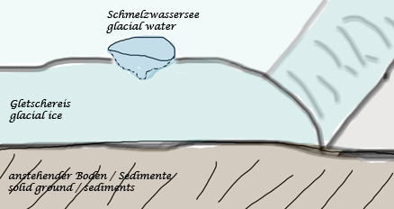
During melting of the glacier water comes to
seas on the glaciers surface.
Eine weitere Erhöhung der Temperatur führte zur Vergrößerung der
Schmelzwasserseen und deren Ausdehnungen in Breite und Tiefe. Durch
Risse und Spalten drang das Schmelzwasser bis an den Boden des
Gletschers.

Further temperature raise leads to largers seas
and larger measurements in width and depth. Due to cracks in ice
the surface water flows down to the ground of the
glacier.
Das durchströmende Wasser vergrößerte die Röhre bzw. den Riss im
Eis. Dadurch strömte noch mehr Schmelzwasser mit noch größerer
Geschwindigkeit zum Boden des Gletschers und lockerte das Sediment
am Gletscherboden.
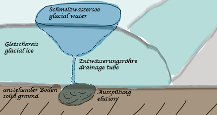
The flowing water increased size of the tube or
the crack in the glacier. Due to this the glacial water flows with
increased spead to the glaciers ground and limbers the sediments at
the ground.
Der Druck am Boden des Gletschers stieg durch nachströmendes
Schmelzwasser enorm an. Die ausgespülte Rinne wuchs solange an, bis
sie unter dem Gletschereis wieder an die Oberfläche trat. Dabei
wurden die gelösten Sedimente ausgespült und mit dem Schmelzwasser
abtransportiert.

The pressure at the ground increased due to more
glacial water flowing down. The flushed groove grows until it come
back to the surface at the end of the glacier.
Nach dem weiteren Abschmelzen des Gletschereises blieb die
ausgespülte Rinne als Rinnensee zurück. Die Rinne des
Schwielochsees ist ca. 11km lang, bis zu 2,5 km breit und im Mittel
9m tief. Einige Findlinge am Ufer des Schwielochsees zeugen noch
heute von seiner eiszeitlichen Entstehung.
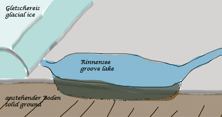
After further melting of the glacial ice the
groove stays as a lake. The groove of the Schwielochsee is approx.
11km in length, up to 2,5km wide and has an average depth of 9m. A
few erratic blocks at the banks are an evidence of its glacial
origin.
Um diesen Earthcache zu loggen, müsst Ihr folgende Aufgaben
erledigen:
- Stattet dem Schwielochsee an den oben genannten Koordinaten
einen Besuch ab.
- Untersucht das Wasser auf Schwebstoffe. Beschreibt uns deren
Aussehen und stellt eine Vermutung an, was es sein könnte.
- An den angegebenen Koordinaten findet Ihr eine Dreiergruppe
kleinerer Findlinge. Messt den Umfang jedes einzelnen Findlings
(10cm Genauigkeit!) und gebt die ungefähre Farbnuance dazu an.
Hinweis: Je nach Wasserstand können die Findlinge ganz oder
nur teilweise im Wasser liegen oder frei zugänglich sein. Stellt
sicher, dass Ihr die Findlingsgruppe an exakt den angegebenen
Koordinaten untersucht.
- Nennt uns mindestens zwei weitere bekannte Eiszeitseen in
Brandenburg.
- Freiwillige Aufgabe: Wenn möglich, macht vor Ort ein
spoilerfreies Foto von eurem Besuch. Wenn Geologen Gesteine, Felsen
oder andere Formationen fotografieren, befindet sich stets ein
Referenzobjekt zur Größenbestimmung mit auf dem Bild. Normalerweise
ist dies ein Hammer, ein Taschenmesser oder ein Zollstock, der die
Abschätzung der Größe ermöglicht. Es ist euch freigestellt, ob und
welches Objekt ihr benutzt, solange es bei der Größenbestimmung
hilft. Dieses Verfahren ist gängiger Standard. Qualitativ gute
Fotos zu machen ist Bestandteil der Außentätigkeit von Geologen und
außerdem würden wir gern die Fotos von eurem Besuch sehen.
- Mailt uns die Antworten und loggt den Cache (mit dem Foto). Ihr
braucht nicht auf eine Freigabe zu warten. Wir melden uns, falls
etwas nicht stimmt.
Nur die korrekten Antworten gelten als
Logberechtigung.
Wir wünschen Euch viel Spaß bei dieser
geologischen Entdeckungsreise.
Viele Grüße vom Team DerkleineHasi
The largest natural lake in brandenburg with glacial
origin
The lake Schwielochsee with an area of
13,3km² is one of the most well known lakes in the state of
Brandenburg. In common with its surrounding area it is important as
an area of vacation and recreation. Beside this it has importance
as a storing space during floods and supports the drain of the
spree-river at low water. However, not much is known about the
origin of the lake Schwielochsee. This earthcaches takes you to the
lake Schwielochsee and explains it's origin to you.
During the weichsel glacial, approx. 122.000 -
10.700 years ago, northern germany was covered completely by
glaciers. During the melting of the huge amount of glacial ice the
melted water flows not only on the surface but additionally through
cracks in ice. In this way it comes to the ground of the glacier
very quickly. The water flows with high speed and was under
pressure. If there were some not solidified sediments, a
considerable amount of material was degraded. The so created
concave figures can be up 50km long and a few hundred meters wide.
The depth is usually between a few and more than 50 meters. Today
some slopped grooves are known that are up to 500 meters in depth.
If such a groove is flooded with water, we call it a groove lake.
The lake Schwielochsee is such a lake. Have a look at the picture
story above for a more detailled explanation.
To log this earthcache you are required to
fulfill the following tasks:
- Visit the lake Schwielochsee at the mentioned coordinates.
- Look at the cloudiness of the water. Do you see a high level of
supended load? If so, describe it. What do you feel is the
load?
- At the upper coordinates you'll find three smaller erratic
blocks. Measure the perimeter of each of the three erratics
(accuracy: 4 inches) and tell us the color of the stones.
Hint: Depending on the level of water the erratics are
located partially or totally in the water. Make sure you find the
correct ones that are located exactly at the coordinates.
- Find out the names of two other well known lakes in state of
Brandenburg with glacial origin.
- Optional Task: If you are able, post a picture free of
spoilers of your visit at the site. When photographing rocks,
stones or other features, geologists usually include an object for
scale in the picture. It's usually a hammer, a pocket knife or a
ruler which can be used to estimate the size of the object. It's up
to you which object you use as long as it helps for estimating the
scale of the object in the picture. This procedure is common
standard. Taking good quality photographs is part of the field work
for geologists. Additionally we would really love to see pictures
from your visit.
- Mail us the answers of the questions and log the cache (with
the picture). You don't need to wait for approval. We'll contact
you if something is wrong with your answers.
Only the correct answers are a valid log authorization.
Have a nice geological expedition
Team DerkleineHasi
|