As an earthcache, there is no “box” or
“container” to discover. Rather, with this cache, you
discover something about the geology of the area. For more info,
consult www.earthcache.org
This earthcache is on the corner of SE Kelso Rd. and SE Richey
Rd. in rural Boring, OR. It is about a 15 minute trip from I-205
(Sunnyside exit).
Geology:
Mt. Hood, a volcanic mountain in the High Cascades chain is
visible over the nearby fields. The entire High Cascades province
is characterized by a north-trending belt of upper Miocene to
Quaternary volcanic rocks that were erupted on the east margin of
the upper Eocene to Miocene Western Cascades province. The late
Pleistocene record of this volcanic activity is well preserved on
the crest of the High Cascades. In other words, the rocks that form
the Cascades were placed there relatively recently, making these
mountains “young” in comparison to many other mountain
ranges. If you look at a map, you can see that there are a series
of mountains that are part of this High Cascades platform –
Mount Hood, Mount Jefferson, Three Sisters, and Mount Mazama
(Crater Lake) to name a few. These volcanic centers have been
responsible for major eruptions and flows of pyroclastic material.
The pyroclastic material has been a variety of rock types –
basalt, andesite, dacit, and rhyolite to name a few.
History:
Mount Hood can still be considered a potentially active volcano!
Mt. Hood has erupted at least twice in the past 1,500 years, the
most recent major eruption being sometime just prior to 1805-1806
when Lewis and Clark visited the region.
On October 29, 1792, British Lt. William Broughton, under the
command of George Vancouver, identified and named the peak after
Lord Samuel Hood a respected admiral of the British Royal Navy.
1805-1806 – Lewis and Clark – in their expeditions
of discovery into the west their journals and maps mention Mt. Hood
on several occasions between November of 1805 and April of 1806.
Overall, they appear fascinated by the snowy peaks of this volcanic
chain, though it is unclear whether they understand the magnitude
of what they have discovered.
There is a great map that highlights their volcanic mountain
discoveries:
http://vulcan.wr.usgs.gov/LivingWith/Historical/LewisClark/Maps/map_volcanoes_lewis_clark.html
1859, 1865 – minor eruptions lasting a few hours were
viewed by W.F. Courtney (1859) and a soldier posted at Fort
Vancouver (80 miles away) (1865).
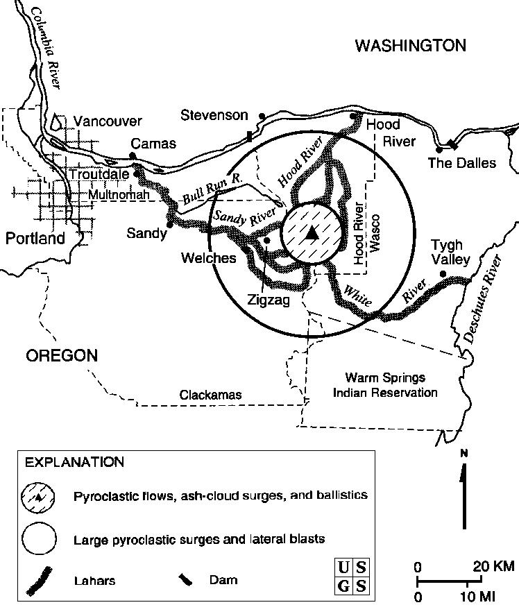
Volcanoes provide a variety of dangerous
conditions.
- Bombs – These are rocks that are expelled from the
volcano. They usually fall rather close to the volcano itself.
- Pyroclastic Flow – Fluidized
masses of rock fragments and gases that move rapidly in response to
gravity. Pyroclastic flows can form in several different ways. They
can form when an eruption column collapses, or as the result of
gravitational collapse or explosion on a lava dome or lava flow.
The flow is fluidized because it contains water and gas from the
eruption, water vapor from melted snow and ice, and air from the
flow overriding air as it moves downslope. They flow very quickly
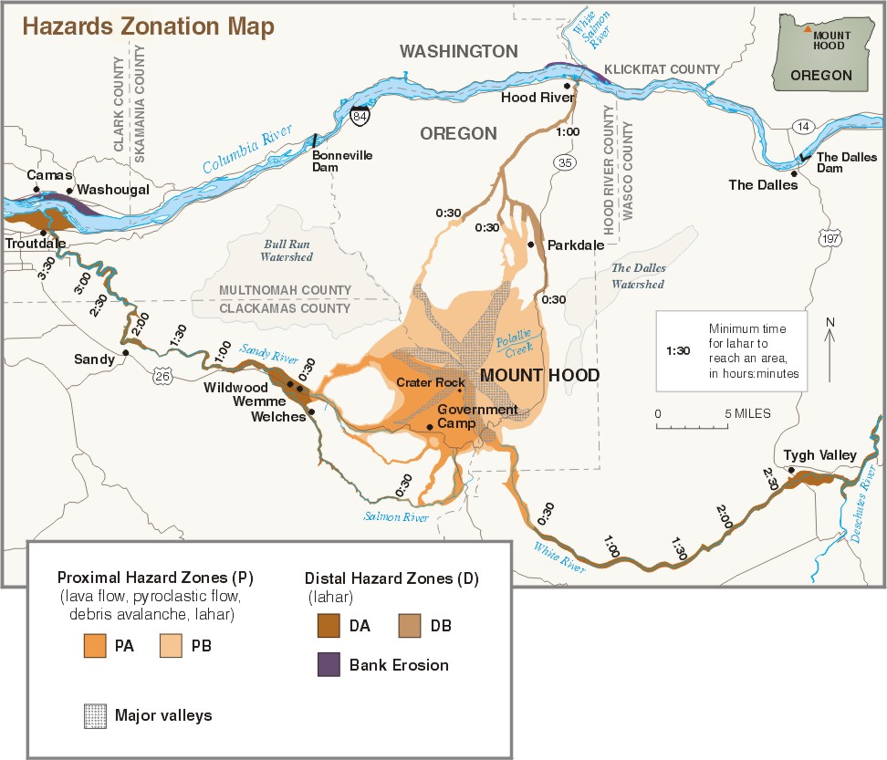
sometimes at a rate of over 100 mph. The Hazards Zonation map shows
the areas most likely to be affected by this type of flow.
- Lava Flow – these flows of molten rock are expelled from
a volcano by a non-explosive effusive eruption. A great example of
this is the Hawaii volcanoes. While destruction can be great, they
move slowly and systematically.
- Lahar – Volcanic mudflows that may be started by an
eruption event. They travel quickly (up to 60 mph) and have been
know to travel 190 miles from their source. They are the
consistency of concrete – fluid when moving, but solid when
they stop. The Hazards Zonation map shows shows times of estimate
arrival of this type of flow in surrounding towns. (this type is
the most likely to affect the greater Portland area).
- Tephra (Ash) Fall / Acid Rain – Technically, Tephra is
any of the rock material tossed into the air by an explosive
volcano. Tephra is not typically immediately dangerous but can lead
to climate cooling, additional snowfall, and acid rain.
Dangers to Portland:
The most likely widespread and hazardous consequence of a future
eruption would be for lahars (rapidly moving mudflows – mixed
with melted snow) to sweep down the Sandy/Zigzag and White River
valleys towards Portland. Lahars are typically caused by hot
volcanic flows that melt the snow and ice that then push sediment
and rock in the madly rushing liquid flow down the river valleys.
Lahars can also be caused by landslides that are loosened during
and eruption.
Lahars can be up to 100 vertical feet “deep” and
thus cause massive destruction to dams and the
residences/businesses along river banks.
According to the USGS, the probability of eruption- generated
lahars affecting the Sandy and White River valleys is 1-in-15 to
1-in-30 during the next 30 years, whereas the probability of
extensive areas in the Hood River Valley (Portland) being affected
by lahars is about ten times less. Pumice is the ash/rock that some
volcanos “throw” when they explode. Based on eruptions
of Mt. Hood in 1859 and 1865, rocks about 2-3 cm in size are
scattered within a 3 mile radius of the summit. Since Portland is
about 80 miles away, the chance of sizable pumice hitting the
ground is unlikely. However, experiences from the lateral blast of
Mt. St. Helens in 1981 show us that ash can travel hundreds of
miles. Residents of Portland had sizable quantities of the fine ash
deposited on their cars, lawns, and houses after that blast.
Future eruptions of Mount Hood could seriously disrupt
transportation (air, river, and highway), some municipal water
supplies, and hydroelectric power generation and transmission in
northwest Oregon and southwest Washington.
Congrads to PDXJim for FTF (First to Finish logging
requirements)
Logging Requirements:
Send the answers to #1-#4 to me through my geocaching
profile.
- List the name “GC239E9 Mt. Hood View Earthcache” in
the first line of your email. Also, list the number of people in
your group.
- (If you can see the mountain) Contrast the mountain peak shape
and size with surrounding hills. Describe two DIFFERENCES and one
SIMILARITY.
- Based on the information above, what might be the danger(s) to
Portland if Mt. Hood should explode?
- 11161' is Mt. Hood summit. Based on your altitude at this
location, how many vertical feet separate you from the summit?
- These are the cords to Mt. Hood’s summit: N45 22.412 W121
41.733. Enter them into your GPS unit. How far away is Mt. Hood
from this location? Based on historic effect patterns, what
type/size of rocks/flow might affect the spot you are standing on
now?
- (Per current gc.com guidelines, photos are no longer allowed to
be required. HOWEVER they are encouraged, since they can help
clarify that you have visited the location if your other logging
requirement answers are vague). Post a picture of yourself and/or
your GPS with your log that shows Mt. Hood in the background. DO
NOT show any of the pertinent information panels in your picture or
your log may be deleted.
I will only respond if you have incomplete
logging requirements. Go ahead and log your cache
Resources:
USGS –
http://vulcan.wr.usgs.gov/Volcanoes/Hood/