Earthcache Neubürg
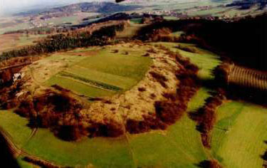
Die Neubürg ist ein 587m hoher Zeugenberg am Rand des Fränkischen Jura und ermöglicht einen einzigartigen Rundblick über das gesamte Umland vom Fichtelgebirge und Bayreuth über die Fränkische Schweiz bis in die Gegend von Bamberg.
Entstanden ist die Neubürg im Jura, genauer im weißen Jura oder Malm (vor ca. 160 Millionen Jahren, siehe Abb. unten). Die Juraformation ist in Deutschland besonders im Schwäbischen und Fränkischen Jura entwickelt. Vor Jahrmillionen wogte hier das Jurameer. Die abgestorbenen Kalkschalentiere versteinerten und wurden am Ende der Jurazeit um viele hundert Meter gehoben, wobei das Meer abfloss.
Die oberste Schicht oder Krone der Neubürg besteht aus Werk- und Schwammkalkfelsen. Vor allem am Südwestrand sind die riffartigen, langsamer verwitternden Schwammkalkfelsen zu bewundern. Diesen folgt eine wasserdurchlässige, trockene Steinbodenschicht des Ornatentons, auf dem sich Laubwälder befinden. Dazwischen gedeihen auf Trockenrasen kalkblühende Pflanzen (z.B. der gelbe Wundklee, der weiße Mauerpfeffer, die wilde Salbei, die Zypressenwolfsmilch,…). Aufgrund der erosionsbedingten Herausbildung wird die Neubürg auch als Insel- oder Zeugenberg bezeichnet, da sie die vormals ganz in der Umgebung überlagernden Gesteinsschichten „bezeugt“. Diese Randerhebung der Fränkischen Schweiz hat eine Fläche von 280m Länge und 160m Breite.

Die Neubürg soll bereits in der Altsteinzeit vor ca. 14.000 Jahren besiedelt gewesen sein. Funde belegen sogar eine keltische Besiedlung aus dem 7. und 6. Jahrhundert vor Christus. Anfang des 20. Jahrhunderts wurden Teile der Neubürg als Steinbruch zur Straßenbeschotterung genutzt.
Seit 2003 verbindet das ausgezeichnete Landschaftsschutzgebiet Natur und Kunst zum sog. NaturKunstRaum, in dem verschiedene regionale aber auch internationale Künstler ihre Skulpturen auf dem Berg verteilt, präsentieren.
Auch ranken sich zahlreiche Sagen um den markanten Berg. Sie handeln u.a. von Zwergen, die im Berg hausten und von einem Goldschatz der im Inneren des Berges versteckt sein soll.
Nun zu diesem Earthache:
Parken könnt ihr am besten bei: N49° 53.581 E011° 24.129;
dort findet ihr auch einige Informationstafeln, die ihr zum Lösen der folgenden Aufgaben benötigt:
-
Für einen solchen Zeugenberg, wie die Neubürg einer ist, gibt es noch eine weitere geologische/geomorphologische Bezeichnung. Wie kann diese Art von Berg noch genannt werden?
-
Wie wird die Neubürg im Volksmund noch bezeichnet?
-
Wann wurde der alte Eichenwald auf der Neubürg gerodet?
Geht nun bis zum Plateau der Neubürg. Auf dem Weg dorthin findet ihr bei N49° 53.517 E011° 24.203 eine Skulptur:
-
Wie heißt dieses Kunstwerk, bei dem ein typisches Leitfossil des Jurameeres dieser Region „verarbeitet“ wurde? Einen Extrapunkt gibt es für die Bezeichnung des Fossils ;-)
Bei N49° 53.464 E011° 24.128 habt ihr euer Ziel erreicht. Ihr seid beim „Richtungsweiser“ angelangt. Macht dort euer Bild von euch für den Logeintrag (in welche Richtung ist euch hier selbst überlassen; mittlerweile leider nur noch auf freiwilliger Basis, ich appelliere allerdings an eure Earthcacher-Ehre!).
Zur Logfreigabe:
Ihr dürft diesen Cache sofort loggen, hängt aber euer gemachtes Bild mit an und schickt mir zeitgleich die Lösungen über meinen Account! Solltet ihr nichts mehr von mir hören, war alles korrekt. Wenn nicht, werdet ihr von mir hören!!.
Da es leider nun schon häufiger vorgekommen ist: Ohne die Beantwortung der Fragen keine Logerlaubnis. Ich werde zwar jeden Cacher ohne Beantwortung der Fragen noch einmal anschreiben, sollte darauf aber keine Antwort folgen, sehe ich mich nach den EC-Richtlinien gezwungen den Logeintrag zu löschen!
Dieser Earthcache liegt im Geopark Bayern-Böhmen. Seit kurzem unterstützt dieser Geopark Earthcaches und wird in Zukunft auch eigene Earthcaches legen. Wer weitere Earthcaches im Geopark Bayern-Böhmen besuchen möchte, empfehle ich folgenden Link: http://www.geopark-bayern.de/Public/earthcaching/
PS: Ihr könnt diesen Earthcache noch mit zwei weiteren Tradis in unmittelbarer Nähe verbinden: <<"Cache dir einen" #3: Fratzenstein>> (GC1V8TF) und "NaturKunstRaum" (GCPGA8). Viel Erfolg bei der Suche!
...und nun viel Spaß bei meinem zweiten Earthcache wünscht euch cejn!
...achja, ich habe einige Earthcache-Geocoins zum discovern, wer die Voraussetzungen erfüllt, darf gerne bei mir nach der Trackingnummer fragen...
English Version:
Earthcache Neubürg
The Neubürg is a 587-m-high witness's mountain on the edge of the Franconian Jura and allows a unique panorama above the whole environs of the Fichtelgebirge and Bayreuth over Franconian Switzerland till the area of Bamberg.
The Neubürg has orginated in the Jura more exactly in the white Jura or Malm (before approx. 160 million years, see fig. below). The Jurassic is developed in Germany particularly in the Swabian and Franconian Jura. Millions of years ago there surged here the Jura-Sea. The dead lime shellfish fossilized and were lifted at the end of the Jura time about many hundred metres and the sea ran off.
The uppermost layer or crown of the Neubürg exists of work and fungous lime rock. Above all in the southwest edge the reef-like, more slowly weathering fungous lime rocks are to be admired. A water-permeable, dry stone soil layer of the Ornatentons on which deciduous forests are follows these. In between there prosper on dry grassland lime-blossoming plants (e.g., the yellow sore clover, the white wall pepper, the wild sage, the cypress spurge, …). On account of the erosion-conditioned formation it is called the Neubürg also island mountain or witness's mountain, because she "testifies" the rock strata formerly completely overlaying in the surroundings. This edge elevation of Franconian Switzerland has a surface of 280-m length and 160-m width.
The Neubürg should already have been settled in the Paleolithic age approx. 14,000 years ago. Findings book even a Celtic settlement from the 7th and 6th century B.C. At the beginning of the 20th century parts of the Neubürg were used as a stone quarry for the roads.
Since 2003 the excellent landscape protection area connects nature and art to the so-called "NaturKunstRaum". The physical art space in which different regional however also international artists their sculptures on the mountain distribute present arms.
Also numerous legends entwine themselves round the striking mountain. They act among other things from dwarfs who lived in the mountain and from a hoard of gold inside of the mountain should be hidden.
Now to this Earthache:
You can park best of all with: N49 ° 53.581 E011 ° 24.129;
there you also find some boards of information which you need for solving of the following duties:
1. For such a witness's mountain, as the Neubürg one are, there is still an other geomorphological name. How can this kind of mountain be still called?
2. How is still called the Neubürg in the vernacular?
3. When was the old oaken wood on the Neubürg cleared?
Now goes up to the plateau of the Neubürg. On the way there you find with N49 ° 53.517 E011 ° 24.203 a sculpture:
4. How is this piece of art with which a typical index fossil of the Jura-Sea of this region was "processed" called? There is an extra point for the name of the fossil;-)
With N49 ° 53.464 E011 ° 24.128 you have reached your aim. You have arrived with the "direction wise man". Power there your picture for the log entry (in which direction is to you here leave).
To the log release:
You are allowed to log this cache immediately, however, your made picture clings and sends me at the same time the solutions about my account! Should you hear nothing more from me, everything was correct. If not, you will hear from me!
A lot of fun with my second Earthcache wishes you cejn!
PS: You can connect this Earthcache still with two other tradis in immediate nearness: "Cache dir einen" #3: Fratzenstein (GC1V8TF) and NaturKunstRaum (GCPGA8). A lot of success with the search!
Quellen:
Pfaffenberger, H.: Die Neubürg (Teil I, II & III). In: HHB Nr. 49/2000, 50/2000 & 51/2000
Pfaffenberger, H.: Unser Hummelgau II - Landschaft und Geschichte(n). Mistelgau 1993
Geotopkataster Bayern: "Zeugenberg Neubürg" Geotop-Nummer: 472R046
Informationstafeln vor Ort